This item has been sold, but you can get on the Waitlist to be notified if another example becomes available, or purchase a digital scan.
1845 S.D.U.K Map of the City of Boston
Boston-sduk-1845$150.00

Title
Boston with Charlestown and Roxbury.
1845 (undated) 15 x 11.75 in (38.1 x 29.845 cm) 1 : 16500
1845 (undated) 15 x 11.75 in (38.1 x 29.845 cm) 1 : 16500
Description
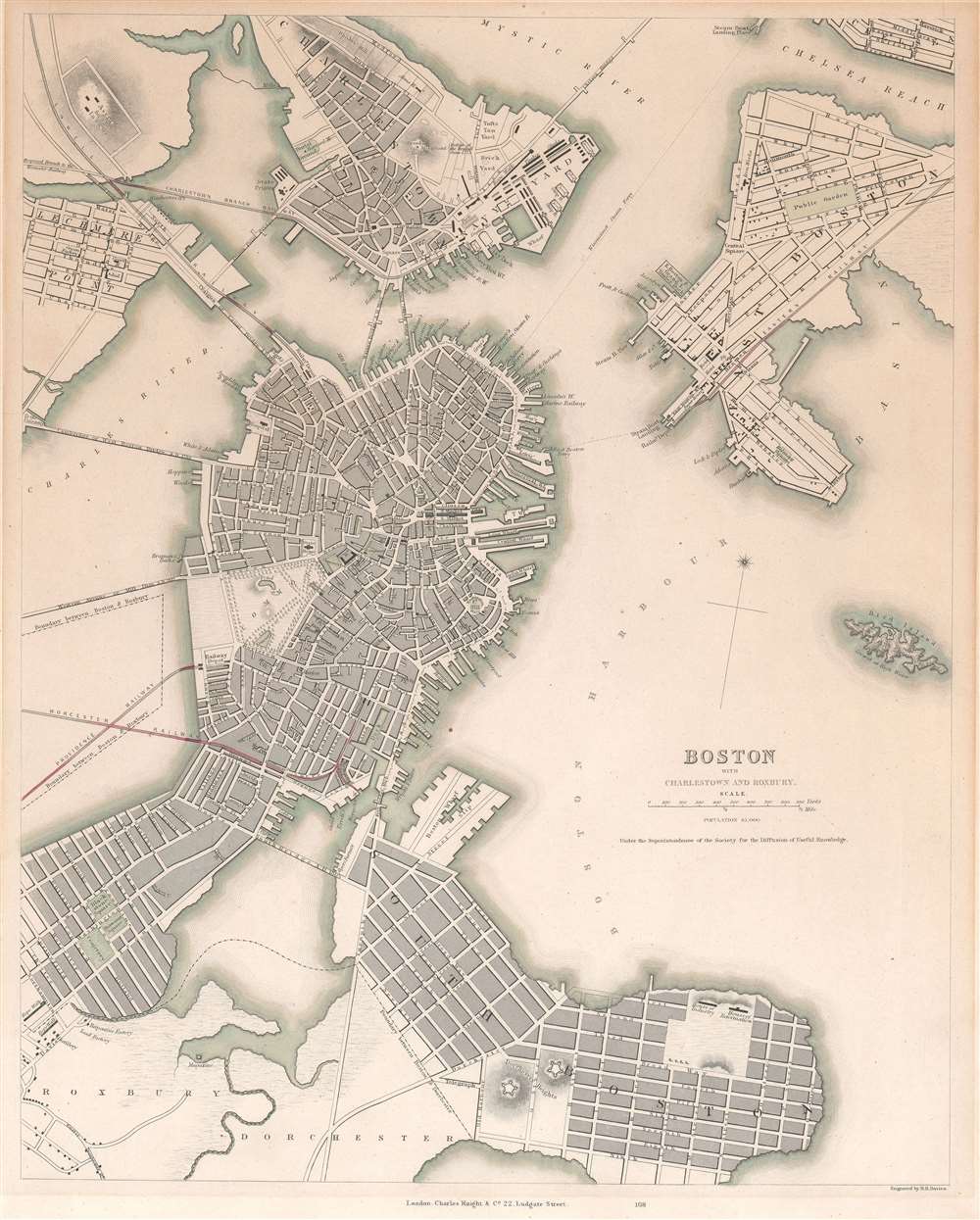
This is an 1845 Society for the Diffusion of Useful Knowledge (S.D.U.K.) map of Boston and its vicinity. The map shows the city from Charlestown and the Chelsea Reach in the north, down to Dorchester and South Boston; the map reaches as far west as Lechmere and part of Roxbury, and as far east as roughly the intersection of Chelsea and East Eagle streets. Bird island appears in the harbor with the notation indicating that it is underwater at high tide. Forts, municipal structures and factories are marked on the map, as are gardens and commons.
The Back Bay
The tracks of the Worcester and the Boston and Providence Railways are shown, running on causeways through the Back Bay, which was not yet filled and still in use as a mill pond. The Boston and Roxbury Mill Dam is shown: this had been intended to enclose the Back Bay and utilize the flowing tidal waters for industrial production. While it succeeded in the enclosure of the bay, doing so caused the body of water to become stagnant and foul. Moreover only a fraction of the factories the dam was intended to power came to be constructed. Thus failing on several fronts, the dam would persist until 1857 when the plan to fill in the Back Bay was commissioned.Publication History and Census
The map was engraved by B. R. Davies and added to S. D. U. K publications in 1842. This example, printed by the Charles Knight firm at their 22. Ludgate Street address, was published in 1845.CartographerS
The "Society for the Diffusion of Useful Knowledge" (1826 - 1848) was a Whiggish organization founded in 1828 at the instigation of idealistic British lord Henry Peter Brougham. The admirable goal of the Society was to distribute useful information via a series of publications to the English working and middle classes. It promoted self-education and the egalitarian sharing of all knowledge. While closely tied to the London University and publishing houses on the order of Baldwin and Cradock, Chapman and Hall, and Charles Knight, the Society failed to achieve its many lofty goals in finally closed its doors in 1848. Most likely the failure of the Society resulted from its publications being too expensive for its intended lower to middle class markets and yet not large and fine enough to appeal to the aristocratic market. Nonetheless, it did manage to publish several extraordinary atlases of impressive detail and sophistication. Their most prominent atlas consisted of some 200 separately issued maps initially published by Baldwin and Cradock and sold by subscription from 1829 to 1844. Afterwards, the Society combined the maps into a single world atlas published under the Chapman and Hall imprint. In its day, this atlas was unprecedented in its quality, scope, and cost effectiveness. Today Society, or S.D.U.K. as it is commonly known, maps are among the most impressive examples of mid-19th century English mass market cartographic publishing available. The S.D.U.K. is especially known for its beautiful and accurately detailed city plans. More by this mapmaker...
Benjamin Rees Davies (1789 - December 16, 1872) was an engraver, cartographer, painter, and map publisher active in the early to mid-19th century. Davies was born in Holborn, England, apprenticed as under John Lodge in 1803. He began publishing around 1811 and is known to have compiled many of own maps from original survey work. From approximately 1848 onward Davies published in conjunction with the Stanford Firm. He is also known to have engraved a number of maps for the Dispatch Atlas and the S.D.U.K. Davies was an early adopter of steel plate engraving and used the exceptional hardness of steel to create some of the most delicately engraved and beautifully produced maps of his era. He was quite famous in England for his detailed street plans of London, which he began publishing in 1848. Davies is known to have worked with numerous other cartographers of his period including French, Mexican, and American map makers. Many of his maps and plans continued to be published and updated posthumously well into the 1880s. Learn More...
Source
S. D. U. K 'Maps of the Society for the Diffusion of Useful Knowledge.' (Knight, London) 1845.
Condition
Very good condition. Some toning and mat burn, else excellent with original tinting.
References
Rumsey 0890.166. Leventhal 06_01_015240. OCLC 137224183.