This item has been sold, but you can get on the Waitlist to be notified if another example becomes available, or purchase a digital scan.
1895 Walker City Plan or Map of Boston, Massachusetts
Boston-walker-1895$100.00

Title
Official Map of Boston.
1895 (dated) 28 x 20.75 in (71.12 x 52.705 cm) 1 : 16000
1895 (dated) 28 x 20.75 in (71.12 x 52.705 cm) 1 : 16000
Description
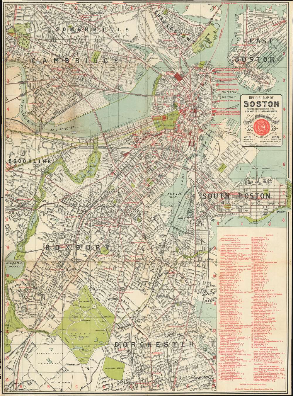
Published for the Fourteenth International Convention of the Young People's Society for the Christian Endeavor, this is an 1895 George H. Walker and Company city plan or map of Boston, Massachusetts. Red overprinting highlights over 100 different locations around the city, including hotels, churches, historic sites, and railroad stations. Seventy-nine of these are numerically labeled, while others are identified by name. Two massive tents erected on Boston Common, named Walliston and Endeavor, hosted many of the convention's events.
The Young People's Society of the Christian Endeavor
The Young People's Society for the Christian Endeavor, founded in 1881 in Portland, Maine, is a nondenominational Christian evangelical society. Begun by Francis Edward Clark, a reverend from Portland, the society's stated objective is 'to promote an earnest Christian life among its members, to increase their mutual acquaintanceship, and to make them more useful in the service of God.' The movement has since spread worldwide and held the 29th C.E. World Conference in Flensunger Hof, Germany in July 2019.Publication History and Census
This map was created and published by George H. Walker and Company in 1895 under the direction of the Committee of Arrangements of the Fourteenth International Christian Endeavor Convention. Five examples are cataloged in OCLC and are part of the collection at Harvard College, the Osher Map Library at the University of Southern Maine, Oberlin College, the Wisconsin Historical Society, and Stanford University.Cartographer
George Hiram Walker (January 4, 1852 - November 14, 1927) was a Boston based publisher of books, views, and maps active in the late 19th and early 20th centuries. Born in Springfield, Vermont, Walker started his life as a dry goods merchant but developed an active interest in publishing during the early 1870s. Walker began publishing in 1878 when he partnered with an unknown New York Firm. Two years later, Walker brought the operation in house by partnering with his brother, Oscar W. Walker, in the opening of a lithography studio at 81 Milk Street, Boston. Shortly thereafter the firm expanded to new offices at 160 Tremont Street, Boston. The Walker brothers produced a large corpus of works, most of which focused on travel and tourism in New England. Walker also established the Walker-Gordon Milk Laboratory with Dr. Thomas Morgan Rotch and Gustave Gordon. This interesting investment was based on the premise that infant deaths could be avoided by providing higher quality milk. The company eventually became a great success, producing a high-quality cow milk that closely resembled human breast milk. In the process the Walker-Gordon laboratory developed many of the dairy health standards that are still with us today. Walker married Irene L. Loud on March 25, 1885. More by this mapmaker...
Condition
Good. Map has been laid down on archival tissue. Exhibits several repaired splits and tears, mostly confined to upper left quadrant, near where originally attached to binder. Some soiling evident, particularly along original fold lines. Minor fill repairs at a couple fold intersections.
References
OCLC 55890357.