This item has been sold, but you can get on the Waitlist to be notified if another example becomes available, or purchase a digital scan.
1960 Winn Historical Pictorail Map of Boston
Boston2-winn-1960$62.50

Title
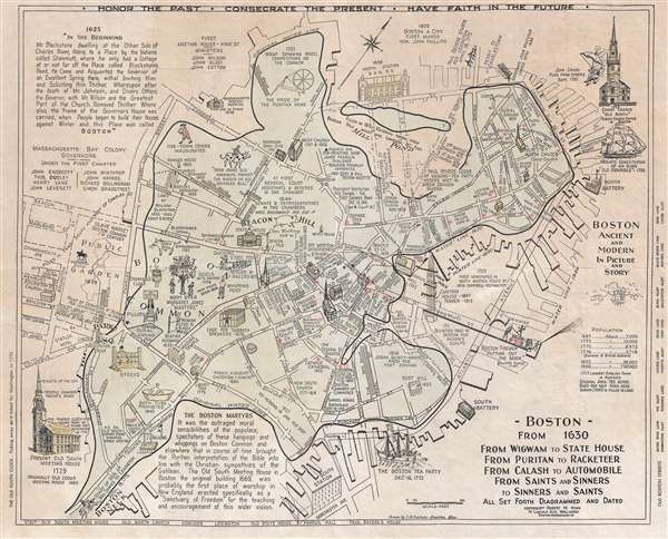
Boston from 1630 From Wigwam to State house From puritan to Racketeer From Calash to Automobile From Saints and Sinners to Sinners and Saints All Set Forth Diagramed and Dated.
1960 (undated) 16.5 x 21 in (41.91 x 53.34 cm) 1 : 6000
1960 (undated) 16.5 x 21 in (41.91 x 53.34 cm) 1 : 6000
Description
A delightful c. 1960 broadside historical pictorial map of Boston. Drawn by Ivan A. Chisholm, of Braintree Massachusetts, and published by Robert M. Winn, this pictorial map attempts to illustrate the history of Boston on a single sheet. While major streets and such are named, the real focus is the heavy annotation which describes historical events. Subjects covers range from the former 'Slave Market' in the Boston Common, the 'Cage for Sabbath Breakers' near St. Paul's Cathedral, to the Bath Tub prohibition of 1845.
Winn issued various historical map of Boston from his offices at 74 Lincoln Ave, Wollaston, Boston. On request, he would also antiquate maps to make them appear old.
Winn issued various historical map of Boston from his offices at 74 Lincoln Ave, Wollaston, Boston. On request, he would also antiquate maps to make them appear old.
Condition
Average. Backed on archival tissue.
References
OCLC 166645814, 244679030.