1881 Russell Cyanotype Route Map of the Boston and Albany Railroad
BostonAlbanyRR-russell-1881$1,500.00

Title
Road Department. Boston and Albany R.R. Sheet No. 1045.
1881 (dated) 28.25 x 27.5 in (71.755 x 69.85 cm) 1 : 422400
1881 (dated) 28.25 x 27.5 in (71.755 x 69.85 cm) 1 : 422400
Description
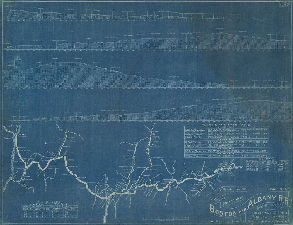
This is an 1881 cyanotype route map of the Boston and Albany Railroad created by William H. Russell, the railroad's Chief Engineer. The route map occupies the bottom quarter of the sheet and illustrates the Boston and Albany's Main Line along with numerous branch lines. Stops are identified along the lines with small lines illustrating and identifying connecting railroads. A table above the route map details the Boston and Albany's four divisions.
Route Profiles
Route profiles occupy the upper three-quarters of the sheet. Each profile marks milage and stops. Inclines and elevations are also noted.The Boston and Albany Railroad
The Boston and Albany Railroad was chartered on June 23, 1831 as the Boston and Worcester Railroad to compete with the recently completed Erie Canal (1825).Boston businessmen saw the Erie Canal as a threat to their regional trade hegemony. The Berkshires Mountains of western Massachusetts made constructing a competing canal impractical, thus a railroad was planned. Construction began in August 1832 and service to Worcester began on July 4, 1835. (Importantly, the Boston and Worcester introduced season passes to West Newton in 1843, effectively creating a commuter rail.) The Western Railroad, created to connect the Boston and Worcester with the Hudson and Berkshire Railroad, was incorporated on March 15, 1833, and full service began on October 4, 1841. A third railroad, the Castleton and West Stockbridge Railroad, began construction in New York in 1840 as the New York section of the Western Railroad. It reached Massachusetts in September 1842 and was leased for 50 years to the Western Railroad in November 1843. Two mergers, one on September 4, 1867, and another on December 28, 1870, combined the three companies as well as the Hudson and Boston Railroad, into the Boston and Albany Railroad. At the time, the Boston and Albany was the longest and most expensive point-to-point railroad constructed in the United States. The New York Central and Hudson River Railroad signed a ninety-nine year lease of the Boston and Albany beginning on July 1, 1900, which then transferred to the New York Central in 1914.Cyanotype: Why so Blue?
Cyanotype is a photo-reprographic technique developed in 1842 by the British astronomer John Herschel (1792 - 1871). Sometimes called a 'sunprint', the technique employs a solution of ferric ammonium citrate and potassium ferricyanide, which painted on white paper or cloth, reacts when exposed to sunlight to dye the object a brilliant blue. Areas blocked from ultraviolet exposure remain undyed and white. Herschel developed the technique to reproduce his astronomical notes, but others quickly realized that any object capable of blocking light could be used to quickly and easily create a cyanotype image. By the late 19th century, the process became popular with designers, military, architects, and engineers (blueprints), who used the cheap an effective technique to quickly and exactly reproduce images in the field. Cyanotyping is limited in that only a single copy can be made at one time, so it was only practical for short-term field work. It is also of note that cyanotypes remain extremely reactive to light and, over time, fade or degrade, making them extremely ephemeral. The process fell out of fashion in most places by the 1920s but remains in use in some parts of the world, such as India and Nepal, to this day.Publication History and Census
This map was created by William H. Russell for the Boston and Albany Railroad and published in Springfield as Sheet No. 1045 in 1881. This is the only known surviving example.Cartographer
William Henry Russell (October 25, 1818 - December 8, 1894) was an American railroad engineer. Russell started working on railroads at the age of eighteen in 1836, when he held chains for surveyors on the Western Railroad in the Berkshires. He worked for Western until 1842, when he moved to Ellington, Connecticut and tried his hand at farming. That lasted for three years, after which he worked as a surveyor for the New York, New Haven, and Hartford Railroad. At some point he moved to the Cheshire and New London Railroad, before ending up with the Boston and Albany as the Chief Engineer in 1858. He served as Chief Engineer until October 1894 (a tenure of thirty-six years), when he became the Consulting Engineer, a position created for him. During his time with the Boston and Albany, Russell worked on the 'snow-plow and wrecking train'. Near the end of his tenure as Chief Engineer, assistants took much of the work off his shoulders, but 'at a washout or serious accident, Engineer Russell is always on hand and is general in the field of action. […] But he knows just how to do things, and natural skill supplements his familiarity with engineering rules.' He died two months later, on December 8, 1894. More by this mapmaker...
Condition
Good. Backed on archival tissue for stability. Parts of top and bottom right corner reinstated. Closed tear extending one (1) inch into printed area from lower margin professionally repaired on verso.