1783 Lodge / Millar View Map of Boston, Charleston, and Battle of Bunker Hill
BostonBunkerHill-lodge-1783-2$800.00

Title
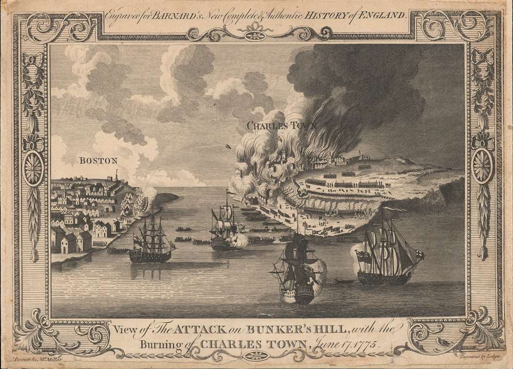
View of the Attack on Bunker's Hill, with the Burning of Charles Town, June 17, 1775.
1783 (undated) 8.5 x 11.5 in (21.59 x 29.21 cm)
1783 (undated) 8.5 x 11.5 in (21.59 x 29.21 cm)
Description
One of the earliest obtainable views of the 1775 American Revolutionary War (1775 - 1783) Battle of Bunker Hill. Published in 1783, this view illustrates the June 17, 1775, Battle of Bunker Hill, near Boston, one of the first and most significant battles of the war.
The overconfident British sailed across the Charles River in a direct assault on the well-fortified position. Although more numerous, better trained, and better equipped, the British forces were thrown back twice before ultimately taking the defensive fortifications on Breed's Hill. Although the Battle of Bunker Hill, as it came to be misnamed, was a loss for the Colonial army, it was a hard-won victory for the British, who suffered 1,054 casualties versus 450 Colonial casualties. Moreover, many of the British casualties were officers and command staff, a crippling setback that undermined British confidence.
A Closer Look
The view looks east from Boston Harbor. Boston is on the left and Charlestown and Breed's Hill are afire on the right. British naval vessels fill the harbor, while long range cannons bombard Charlestown from Boston. The view is reasonably accurate, suggesting that the artist, 'Mr. Millar,' probably George Henry Millar, may have witnessed it firsthand or drew upon the experience of one who had.Battle of Bunker Hill
The Battle of Bunker Hill was one of the earliest and most important battles of the American Revolutionary War. Although identified as 'Bunker Hill', the actual battle was on Breed's Hill. British forces quartered in Boston, then a peninsula, were easily contained by Colonial forces controlling few choke points and surrounding hills. One such, Breed's Hill, was fortified by Colonials when reconnaissance discovered British forces about launch an offensive against the surrounding hills - thus securing Boston.The overconfident British sailed across the Charles River in a direct assault on the well-fortified position. Although more numerous, better trained, and better equipped, the British forces were thrown back twice before ultimately taking the defensive fortifications on Breed's Hill. Although the Battle of Bunker Hill, as it came to be misnamed, was a loss for the Colonial army, it was a hard-won victory for the British, who suffered 1,054 casualties versus 450 Colonial casualties. Moreover, many of the British casualties were officers and command staff, a crippling setback that undermined British confidence.
Publication History and Census
This map was issued at the end of the American Revolutionary War to accompany Edward Bernard's 1783 New, Comprehensive and Complete History of England. It was engraved by John Lodge after a drawing prepared by George Henry Millar and published by Alexander Hogg. This view appears in several institutional collections but is scarce to the market.CartographerS
John Lodge (1735-1796) was a British engraver, map seller, draughtsman and stationer active in London from roughly 1755 to the late 18th century. Lodge, born in London, was apprenticed to Thomas Jefferys, one of the most prominent and prolific map publishers and engravers of his day. He produced several maps for The Gentleman's Magazine and The Political Magazine and other publications. He also engraved book-illustrations, portraits and botanical plates and taught etching and engraving. Around the 1780's, he is believed to have lived to Dublin, where he did a significant amount of engraving work for Dublin booksellers. Lodge was survived by his wife Ann, to whom he left his entire estate, and his son John Lodge, who was also an engraver. More by this mapmaker...
Alexander Hogg (fl. c. 1778-1824) was a London based book, map, and print publisher. Hogg is best known for his publication of the journals of James Cook, but he also published a number of local plans focusing on the British Isles. His offices were based at no. 16 Paternoster Row, London, England. Learn More...
Condition
Good. Remargined on all sides.
References
OCLC 60453662, 1002179710, 549421960.