This item has been sold, but you can get on the Waitlist to be notified if another example becomes available, or purchase a digital scan.
1872 Walling and Williams Map of Boston, Massachusetts, and Adjacent Counties
BostonCounties-wallingwilliams-1872$325.00

Title
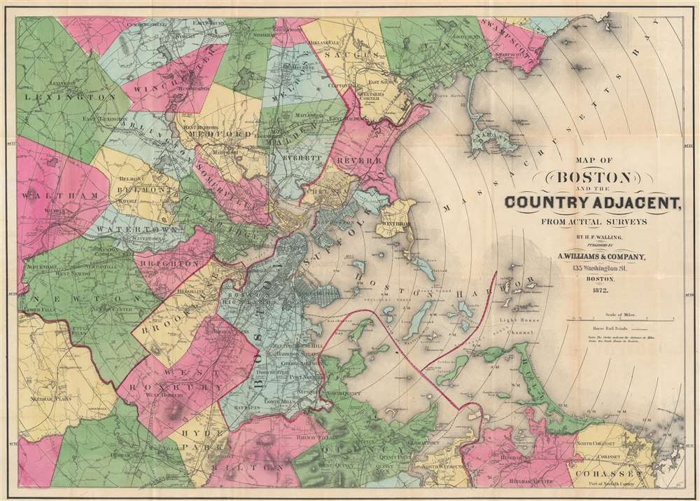
Map of Boston and the County Adjacent, From Actual Surveys.
1872 (dated) 18.25 x 25.75 in (46.355 x 65.405 cm) 1 : 63360
1872 (dated) 18.25 x 25.75 in (46.355 x 65.405 cm) 1 : 63360
Description
This is an 1872 Henry Walling map of Boston, Massachusetts, and the surrounding region. Railroads run in and out of the city, including the Boston and Providence Railroad, the Boston and Worcester Railroad, and the Old Colony and Trail River Railroad. Several horse-drawn streetcar lines are illustrated as well. Boston Common, the hospital, state house, jail, and customs house are labeled within the city. Individual buildings appear, with some identified, such as factories, churches, and train stations. Concentric circles illustrating mile increments emanate from the State House in Boston.
Publication History and Census
This map was created by Henry F. Walling and published by Alexander Walling. At least two maps were published with this title around the same time, and few are digitized, making a confirmed census difficult. We can confirm an 1871 example at the Norman B. Leventhal Map and Education Center, Boston Public Library.CartographerS
Henry Francis Walling (June 11, 1825 - April 8, 1889) was an American civil engineer, cartographer, surveyor, and map publisher active from the middle to late 19th century. Walling was born in Providence, Rhode Island. He studied/worked at the Providence Athenaeum before discovering a talent for mathematics and surveying. Walling took a position with Samuel Barrett Cushing (1846 - 1888), a Providence-based civil engineer with whom he issued in 1846 a revision of James Steven's Topographical Map of the State of Rhode-Island. Walling established himself independently around 1850 and immediately began preparing a series of town plans focusing on Bristol County, near Providence. Buoyed by widespread interest in his plans, Walling expanded his operations to Massachusetts, where, by 1857, he had produced no less than 50 town plans. Apparently, Walling's business model involved a contract with town officials to produce a certain number of maps, after which he acquired the right to print and sell additional copies on his own account. This work eventually led to Walling's appointment as Massachusetts "Superintendent of the State Map", a designation that began appearing on his maps around 1855. While Walling's work focused heavily on city and county maps, he successfully published three scarce state maps: Maine, Vermont, and Rhode Island. In 1856, Walling relocated his headquarters to New York City, where he had better access to quality lithographers. The Civil War (1861 - 1865) proved difficult for Walling, and diminished sales may have forced him into a partnership with Ormando W. Gray, with whom he published numerous state, county, and national atlases in the 1860s and 1870s. Around 1880, Walling took a post with the U.S. Coast Survey, with whom he worked on various charts until requesting a transfer in 1883 to the newly formed U.S. Geological Survey. Walling remained with the Geological Survey until his untimely death of a heart attack in April 1889. More by this mapmaker...
Alexander Williams (August 24, 1818 – January 11, 1900) was a Boston based bookseller and publisher active in the middle to late 19th century. Williams was born near Fort Hill, Roxbury, Boston in 1818, the son of an Episcopalian bookseller, and grandson of Captain Robert Williams. As a young man he was indoctrinated into the book trade by his father and uncle, then the largest booksellers in Boston, who operated under R. P. and C. Williams on Cornhill Square at 209 Washington Street. It is said that the Cornhill bookstore was a popular hangout for luminaries of the period, including Emmerson, Longfellow, Willis, Sargent, Holmes, and others. In 1832 Williams moved to New York in order to expand his knowledge of the book trade under Elam Bliss, a New York bookseller and publisher. In New York, Williams befriended Aaron Burr, J. Fennimore Cooper, Fitz Green Halleck, and Washington Irving, among others. Williams returned to Boston in 1840 to take a position with George W. Redding in the publishing and magazine distribution department of Redding and Company. By 1841, he had become a silent partner in the Redding firm setting up a magazine delivery service throughout New England. By 1855 the newspaper and magazine delivery service became so prosperous that the partners determined to split it off as the New England News Company, with Williams as the head and primary shareholder. Shortly thereafter, Williams left the New England News Company to work again with his father and uncle on Washington Street. In 1869, one of the most iconic bookstores in Boston, the Old Corner Book Shop (27-29 Bromfield Street) became vacant. Williams took it over, operating it until his retirement in 1869. In 1883, he dissolved the old Cornhill Shop, which was at the time a partnership consisting of Williams, C. L. Damrell, H. M Upham, and J. G. Cuppers. Williams lived at 139 Newbury Street, Boston. He died in 1900 of complications relating to pneumonia and advanced age. He was survived by two sons, Alexander Williams J. and Charles C. Williams, and one daughter. Learn More...
Condition
Very good. Light wear along original fold lines. Verso repairs at fold intersections.
References
Boston Public Library Norman B. Leventhal Map Center G3764.B6 1871 .W3.