This item has been sold, but you can get on the Waitlist to be notified if another example becomes available, or purchase a digital scan.
1930 Lufkin Pictorial City Plan or Map of Boston, Massachusetts
BostonElevatedRailway-lufkin-1930$187.50

Title
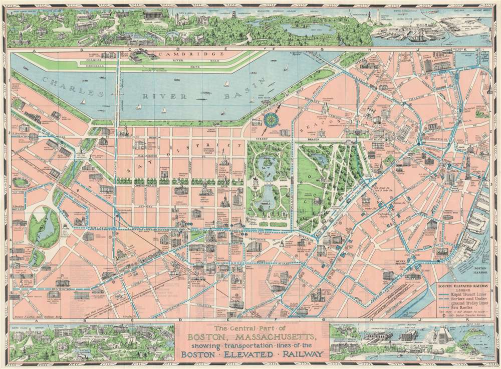
The Central Part of Boston, Massachusetts, showing transportation lines of the Boston Elevated Railway.
1930 (undated) 22.25 x 30.25 in (56.515 x 76.835 cm)
1930 (undated) 22.25 x 30.25 in (56.515 x 76.835 cm)
Description
This is a 1930 Richard F. Lufkin pictorial city plan or map of Boston, Massachusetts. Focused on the central part of the city, blue lines trace Boston's elevated railway ('El'), subway, bus, and trolley lines. The solid blue lines, long-dashed lines, and short-dashed lines all mark different types of rapid transit. Unfortunately, between the key in the lower-left corner and the map itself, it is unclear exactly which type of mass transit is represented. It appears that the solid line and the long-dashed line mark the subway, elevated railway, and the trolley lines interchangeably. The only truly clear annotation concerns the bus lines, which are traced by the short-dashed lines. Stations are labeled, including the Park Street Stations on Lafayette Mall, which are illustrated in profile. Boston's many landmarks are depicted in profile, including Fenway Park, Trinity Church, the State House, Massachusetts General Hospital, and the Massachusetts Institute of Technology across the Charles River in Cambridge. Boston Common and the Public Garden appear as a green island in the middle of the city. Small bird's-eye views act as the top and bottom borders. They include views of Harvard University's campus, Middlesex Fells Reservation, the U.S. Navy Yard, the municipal airport, and South Boston, with numerous buildings illustrated in profile in each place.
The Boston Elevated Railway
The Boston Elevated Railway was founded in 1894 to get traffic off of Boston's streets to ease congestion. Construction began in January 1899 and started operations on June 10, 1901. The subway, which was operated by the same company, opened in September 1897, the first subway in the United States. The 'El' was popular through the 1940s and carried 325,000 people a day in 1943. However, after World War II, public opinion began to turn against the 'El.' It was overcrowded, caused a lot of noise, and came to be viewed as an eyesore. These opinions also coincided with increased enthusiasm for underground mass transit. By the mid-1960s, city officials decided it was time for the 'El' to go and slowly began phasing it out. The last elevated train ran in Boston on June 25, 2004.Publication History and Census
This map was drawn by Richard F. Lufkin, printed by the Walker Lithograph and Publishing Company, and published by the Boston Elevated Railway Company in 1930. The OCLC catalogs eight examples, which are part of the institutional collections at Yale University, Harvard University, the Boston Athenaeum, the Osher Map Library at the University of Southern Maine, the University of Illinois at Urbana Champaign, the University of Victoria, Stanford University, and the University of California Berkeley. An example is part of the David Rumsey Map Collection as well.CartographerS
Richard Friend Lufkin (1895-1963) was a professional civil engineer and head of the Richard Lufkin Company (engineers, draftsmen, artists, and cartographers). He was an Abraham Lincoln scholar and published a number of writings and illustrated maps revolving around Lincoln and his time spent in New England. His company produced a number of pictorial maps focused on Massachusetts, as well as for a number of years printing the map of Boston's MTA. More by this mapmaker...
George Hiram Walker (January 4, 1852 - November 14, 1927) was a Boston based publisher of books, views, and maps active in the late 19th and early 20th centuries. Born in Springfield, Vermont, Walker started his life as a dry goods merchant but developed an active interest in publishing during the early 1870s. Walker began publishing in 1878 when he partnered with an unknown New York Firm. Two years later, Walker brought the operation in house by partnering with his brother, Oscar W. Walker, in the opening of a lithography studio at 81 Milk Street, Boston. Shortly thereafter the firm expanded to new offices at 160 Tremont Street, Boston. The Walker brothers produced a large corpus of works, most of which focused on travel and tourism in New England. Walker also established the Walker-Gordon Milk Laboratory with Dr. Thomas Morgan Rotch and Gustave Gordon. This interesting investment was based on the premise that infant deaths could be avoided by providing higher quality milk. The company eventually became a great success, producing a high-quality cow milk that closely resembled human breast milk. In the process the Walker-Gordon laboratory developed many of the dairy health standards that are still with us today. Walker married Irene L. Loud on March 25, 1885. Learn More...
Condition
Very good. Exhibits light wear along original fold lines. Verso repairs to a margin fold separation. A closed margin tear professionally repaired on verso. Short printed index on verso.
References
Rumsey 8300.001. OCLC 1037481695.