This item has been sold, but you can get on the Waitlist to be notified if another example becomes available, or purchase a digital scan.
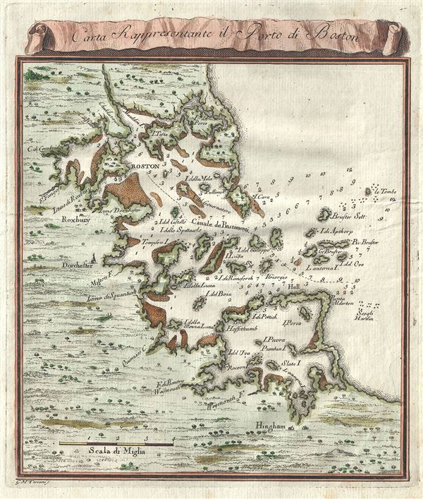
1763 Terreni Map of Boston, Massachusetts and its Vicinity
BostonHarbor-terreni-1763$250.00

Title
Carta Rappresentante il Porto di Boston.
1763 (undated) 9 x 7.5 in (22.86 x 19.05 cm) 1 : 120000
1763 (undated) 9 x 7.5 in (22.86 x 19.05 cm) 1 : 120000
Description
Issued between the French and Indian War and the American Revolutionary War, this is a fascinating 1763 map of Boston, Massachusetts, and its vicinity by G. M. Terreni. Centered on Boston Harbor, this map covers the Boston area from Hingham to Charlestown. Terreni offers extensive detail both inland as well as along the coast, noting several islands, capes, shoals, reefs and depth soundings. Relief is beautifully rendered in profile. This map was issued by G. M. Terreni in 1763 and published in the Masi's Atlante dell'America.
Cartographer
Giuseppe Maria Terreni (1739 - 1811) was an Italian engraver, merchant, artist, and painter active in the middle to latter part of the 19th century. Terreni was born in Livorno, Italy, where he completed most of his artistic works. Between 1783 and 1785 Terreni executed a series of 18 engraved city views of Livorno in the style of Giuseppe Zocchi and Jakob Philipp Hackert. He also published several engraved maps and views in partnership with Lodovico Coltellini for issue in various Italian atlases. He was also, apparently, involved somewhat loosely with the antiquities trade. More by this mapmaker...
Source
Masi, Tomasso, Atlante dell’America (Livorno), 1777.
Condition
Very good. Original platemark visible. Blank on verso.
References
Boston Public Library, G3762.B6 1763. Phillips 1167.