This item has been sold, but you can get on the Waitlist to be notified if another example becomes available, or purchase a digital scan.
1857 U.S. Coast Survey Chart or Map of Boston Harbor, Massachusetts
BostonHarbor2-uscs-1857$300.00

Title
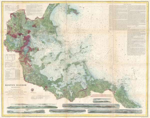
Boston Harbor Massachusetts.
1857 (dated) 29 x 37 in (73.66 x 93.98 cm) 1 : 40000
1857 (dated) 29 x 37 in (73.66 x 93.98 cm) 1 : 40000
Description
This is a hand colored 1857 U.S. Coast Survey chart of Boston Harbor. The chart depicts from Massachusetts Bay through Boston Bay and into Boston Harbor and Boston itself. The detail of the chart is incredible. The bay is shown in precise detail; all the islands are labeled and the coastline of these islands and of Massachusetts are rendered with an intense attention to detail. Inlets, coves and bays abound, as well as river mouths. Boston is not the only city which is labeled, Cambridge, Charleston, Winnissimmet, Quincy Village, Newcomb's Landing and several others are depicted on the chart. The wharves of Boston Harbor are easily distinguished.
More information is included on this chart than simply the depiction of the bay and harbor. Depth soundings are given throughout the bay and harbor. A large paragraph of sailing instructions dominates the upper right corner, followed by a long list of ranges and dangers. 'Remarks on the set of the Tidal Currents' sit above Centre Village and several other urban areas along the upper border. Along the left side, near Roxbury, is a table of abbreviations used on the chart, as well as a table of tides and tidal currents. Along the bottom margin is a table of lighthouses and light vessels, as well as six different coastal views to aid mariners in navigation of the bay and harbor.
This chart was prepared under the direction of A.D. Bache, Superintendent of the U.S. Coast Survey for his Report of the Superintendent of the United States Coast Survey in 1857.
Cartographer
The Office of the Coast Survey (1807 - present) founded in 1807 by President Thomas Jefferson and Secretary of Commerce Albert Gallatin, is the oldest scientific organization in the U.S. Federal Government. Jefferson created the "Survey of the Coast," as it was then called, in response to a need for accurate navigational charts of the new nation's coasts and harbors. The spirit of the Coast Survey was defined by its first two superintendents. The first superintendent of the Coast Survey was Swiss immigrant and West Point mathematics professor Ferdinand Hassler. Under the direction of Hassler, from 1816 to 1843, the ideological and scientific foundations for the Coast Survey were established. These included using the most advanced techniques and most sophisticated equipment as well as an unstinting attention to detail. Hassler devised a labor intensive triangulation system whereby the entire coast was divided into a series of enormous triangles. These were in turn subdivided into smaller triangulation units that were then individually surveyed. Employing this exacting technique on such a massive scale had never before been attempted. Consequently, Hassler and the Coast Survey under him developed a reputation for uncompromising dedication to the principles of accuracy and excellence. Unfortunately, despite being a masterful surveyor, Hassler was abrasive and politically unpopular, twice losing congressional funding for the Coast Survey. Nonetheless, Hassler led the Coast Survey until his death in 1843, at which time Alexander Dallas Bache, a great-grandson of Benjamin Franklin, took the helm. Bache was fully dedicated to the principles established by Hassler, but proved more politically astute and successfully lobbied Congress to liberally fund the endeavor. Under the leadership of A. D. Bache, the Coast Survey completed its most important work. Moreover, during his long tenure with the Coast Survey, from 1843 to 1865, Bache was a steadfast advocate of American science and navigation and in fact founded the American Academy of Sciences. Bache was succeeded by Benjamin Pierce who ran the Survey from 1867 to 1874. Pierce was in turn succeeded by Carlile Pollock Patterson who was Superintendent from 1874 to 1881. In 1878, under Patterson's superintendence, the U.S. Coast Survey was reorganized as the U.S. Coast and Geodetic Survey (C & GS) to accommodate topographic as well as nautical surveys. Today the Coast Survey is part of the National Oceanic and Atmospheric Administration or NOAA as the National Geodetic Survey. More by this mapmaker...
Source
Bache, A. D., Report of the Superintendent of the United States Coast Survey, (Washington) 1857.
Condition
Very good. Wear along original fold lines. Backed on archival tissue for stability.