This item has been sold, but you can get on the Waitlist to be notified if another example becomes available, or purchase a digital scan.
1905 Murphy View Map of Boston Harbor: Boston to Cape Cod
BostonHarborSouthShore-murphy-1905-2$150.00


Title
Bird's Eye View of Boston Harbor and South Shore to Provincetown Showing Steamboat Routes.
1905 (dated) 21.25 x 18 in (53.975 x 45.72 cm)
1905 (dated) 21.25 x 18 in (53.975 x 45.72 cm)
Description
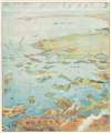
A remarkable chromolithograph map and view of Boston Harbor from Boston to Provincetown - issued for sale on steamships and passenger terminals on the Boston-Provincetown line. The view includes all of Cape Cod Bay, Quincy Bay, and Dorchester Bay, with the communities of Boston, East Boston, South Boston, Dorchester, Quincy, Hough's Neck, Mingham, Nantucket, Duxbury, Plymouth, Cohasset, Scituate, and Provincetown noted. Also notes many of the islands in Boston Harbor including Moon Island, Spectacle Island, Thomson's Island, Long Island, Governor's Island, and many others. Ferry and steamboat routes are noted. Smoke rises from Boston's many manufactories. Today such might be construed as symbol of pollution and urban defilement, but when this view was printed, busy smokestacks were symbols of commercial prosperity and industrial optimism.
Chromolithography
Chromolithography is a color lithographic technique developed in the mid-19th century. The process involved using multiple lithographic stones, one for each color, to yield a rich composite effect. Oftentimes, the process would start with a black basecoat upon which subsequent colors were layered. Some chromolithographs used 30 or more separate lithographic stones to achieve the desired product. Chromolithograph color could also be effectively blended for even more dramatic results. The process became extremely popular in the late 19th and early 20th centuries, when it emerged as the dominate method of color printing. The vivid color chromolithography produced made it exceptionally effective for advertising and propaganda imagery.Publication History
Published by John F. Murphy of South Station, Boston. Dated and copyrighted 1905 by the Federal Engraving and Publishing Co., Boston, Massachusetts.Cartographer
John F. Murphy (fl. c. 1880 - 1920) was a news agent and businessman active in the Boston area during the late 19th century and early 20th century. Murphy managed numerous successful businesses in Boston and the surrounding area, including a number of news stands in railroad stations across the state. He is best known for his publication "Birds Eye Views of Boston Harbor", a tourist oriented map series focusing on Boston Harbor, Cape Cod, the South Shore and Provincetown. More by this mapmaker...
Condition
Very good. Exhibits light wear along original fold lines.
References
Library of Congress, Map Division, G3762.B65A35 1905 .F4.