This item has been sold, but you can get on the Waitlist to be notified if another example becomes available, or purchase a digital scan.
1828 Hayward Map of the Boston-Providence Railroad - First Amercian Railroad Map
BostonProvidence-hayward-1828$475.00

Title
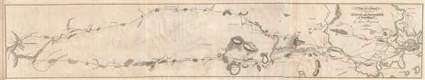
Map of a Survey of the proposed Boston and Providence Rail-Way
1828 (dated) 7.5 x 41.5 in (19.05 x 105.41 cm) 1 : 64000
1828 (dated) 7.5 x 41.5 in (19.05 x 105.41 cm) 1 : 64000
Description
A rare and important discovery, this is the one of the first railroad maps printed in the United States. Issued in 1828 by James Hayward, this is a topographic strip map illustrating two alternate routes for a horse powered rail line between Boston, Massachusetts and Providence, Rhode Island. The map is oriented with west at the top, Boston appears at the far right, and Providence at the far left.
The map illustrates two proposed routes. The easternmost route, at the bottom of the map, begins in South Boston and, passes through Milton, Sharon, and Attleborough, to end at Providence's India Bridge. The western route starts near Madam Swan's Roxbury home and heads south through Purgatory Meadows, Walpole, and Pawtucket to the Blackstone Canal in Providence. The South Boston – India Bridge route was ultimately selected and became today's New Haven Railroad.
This map is the first entry in Andrew M. Modelski's Railroad Maps of North America, a survey of the railroad maps housed in the Library of Congress. Because of this, it has often been considered the first railroad survey map published in the United States. This is probably not the case. There is a similar map that was published about 1 year earlier charting a proposed rail route between Boston and Albany. Nonetheless, it is definitely one of the 2 or 3 earliest railroad maps issued in the United States.
Hayward issued in 1828 report prepared for the Massachusetts Board of Commissioners entitled, Report in Relation to the Examination of Sundry Routes for a Railway from Boston to Providence, with a Memoir of the Survey. Only 1500 were issued, and being ephemeral by nature, few have survived. It was one of the first maps lithographed and published by the Senefelder Lithography Company of George G. Smith and William B. Annin, which later was absorbed into Pendleton.
CartographerS
John Hayward (fl. c. 1840 - 1860) was a publisher of Gazetteers based in Hartford Connecticut. His work included by national and state Gazetteers, though most of his work focused on New England. Little is known of Hayward's life, but he seems to have been successful and may have attended Yale. Upon his death he was survived by his wife. More by this mapmaker...
Senefelder Lithography (1828 – 1830) was a Boston based lithography firm founded in 1828 by George G. Smith and William B. Annin. They were one of the earliest lithographic firms in the United States. Smith and Annin were originally copper plate engravers who were quick to embrace the new technology of lithography. The company was named after Johann Alois Senefelder, the German playwright who invented lithography. The firm was absorbed into Pendleton Lithography in 1831. Learn More...
Source
Hayward, J., Report in Relation to the Examination of Sundry Routes for a Railway from Boston to Providence, with a Memoir of the Survey (Boston: Massachusetts Board of Commissioners) 1828.
Condition
Very good. Slight offsetting. Some toning, left margin. Multiple panels joined by publisher.
References
OCLC 5493553, 13634034.