This item has been sold, but you can get on the Waitlist to be notified if another example becomes available, or purchase a digital scan.
1890 View Map of Boston Harbor from Boston to Cape Cod and Provincetown
BostonProvincetownView-murphy-1890$212.50

Title
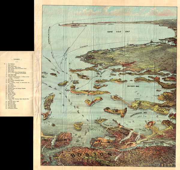
Bird's Eye View of Boston Harbor and South Shore to Provincetown Showing Steamboat Routes.
c. 1890 (undated) 20 x 17 in (50.8 x 43.18 cm)
c. 1890 (undated) 20 x 17 in (50.8 x 43.18 cm)
Description
A remarkable chromolithograph map and view of Boston Harbor from Boston to Provincetown. Includes all of Cape Cod Bay, Quincy Bay and Dorchester Bay with the communities of Boston, East Boston, South Boston, Dorchester, Quincy, Hough's Neck, Mingham, Nantasket, Duxbury, Plymouth, Cohasset, Scituate, and Provincetown noted. Also notes many of the Islands in Boston Harbor including Moon Island, Spectacle Island, Thomson's Island, Long Island, Governor's Island, and many others. Ferry and steamboat routes are noted. Though undated the style is clearly that of the 1890s. Published by John F. Murphy of South Station, Boston.
Cartographer
John F. Murphy (fl. c. 1880 - 1920) was a news agent and businessman active in the Boston area during the late 19th century and early 20th century. Murphy managed numerous successful businesses in Boston and the surrounding area, including a number of news stands in railroad stations across the state. He is best known for his publication "Birds Eye Views of Boston Harbor", a tourist oriented map series focusing on Boston Harbor, Cape Cod, the South Shore and Provincetown. More by this mapmaker...
Condition
Very good condition. Folds into original binder but flattens nicely. Blank on verso.
References
Library of Congress, Map Division, G3762.B65A35 1905 .F4.