1708 De Fer Map of Burgundy and Franche Comte, France (Burgundy Wine)
Bourgogne-defer-1708$500.00
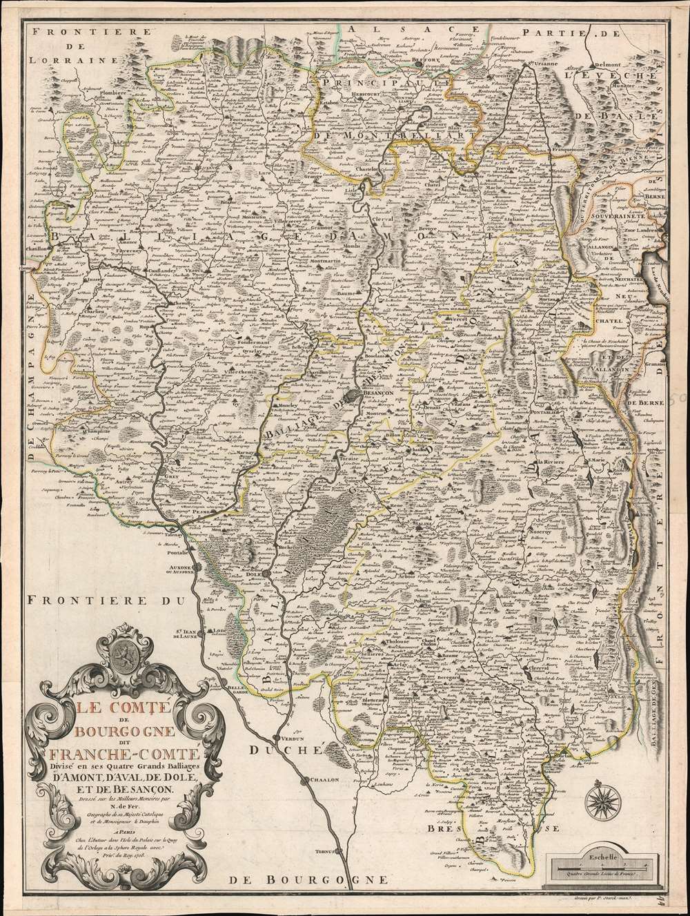

Title
Le Comté de Bourgogne dit France-Comté Divisé en ses Quatres Grands Balliages d'Amont, d'Aval, de Dole, et de Besançon.
1708 (dated) 26.75 x 20.25 in (67.945 x 51.435 cm) 1 : 330000
1708 (dated) 26.75 x 20.25 in (67.945 x 51.435 cm) 1 : 330000
Description
This is a 1708 Nicholas de Fer map of Burgundy and Franche-Comté, France. Beautifully engraved, myriad cities, towns, and villages are labeled throughout the region, including Besançon, Dole, Vesoul, and Belfort. Mountains reference the region's incredible Jura Mountains and forests make clear the region's wooded nature. The Doubs, Saone, and Lougnon Rivers are illustrated and labeled as well.
Wine and Cheese
Two of Franche-Comté's most well-known products are yellow wine (vin jaune) and comté cheese. Vin jaune is a specialty of the Jura region and is a special type of white wine. It resembles a dry Sherry, and even has some similar characteristics, including its aroma, but vin jaune is not a fortified wine. A festival called La Percée du Vin Jaune takes place annually during the last week of January or the first week of February and celebrates the release of the most recent vintage (which would have been harvested seven years earlier). The festival is held in a different village every year, and in recent years it has attracted over 30,000 visitors. Comté is also a specialty of Franche-Comté and is made from unpasteurized cow's milk.Burgundy or Franche-Comté
Historically, Franche-Comté was part of Burgundy, and over the centuries has either been part of Burgundy or has been its own independent province. Today, the region is known as Bourgogne-Franche-Comté after Burgundy and Franche-Comté were merged on January 1, 2016.Publication History and Census
This map was created by Nicolas de Fer and published in 1708. Eight examples are cataloged in OCLC and are part of the institutional collections at the Bibliothèque nationale de France, the Bibliothèque de Genève, the Newberry Library, the Bayerische Staatsbibliothek in Munich, the Deutches Museum Bibliothek in Munich, the Biblioteca Nacional de España, the University of North Carolina Wilmington, and the Landesbibliothek Coburg.Cartographer
Nicholas de Fer (1646 - October 25, 1720) was a French cartographer and publisher, the son of cartographer Antoine de Fer. He apprenticed with the Paris engraver Louis Spirinx, producing his first map, of the Canal du Midi, at 23. When his father died in June of 1673 he took over the family engraving business and established himself on Quai de L'Horloge, Paris, as an engraver, cartographer, and map publisher. De Fer was a prolific cartographer with over 600 maps and atlases to his credit. De Fer's work, though replete with geographical errors, earned a large following because of its considerable decorative appeal. In the late 17th century, De Fer's fame culminated in his appointment as Geographe de le Dauphin, a position that offered him unprecedented access to the most up to date cartographic information. This was a partner position to another simultaneously held by the more scientific geographer Guillaume De L'Isle, Premier Geograph de Roi. Despite very different cartographic approaches, De L'Isle and De Fer seem to have stepped carefully around one another and were rarely publicly at odds. Upon his death of old age in 1720, Nicolas was succeeded by two of his sons-in-law, who also happened to be brothers, Guillaume Danet (who had married his daughter Marguerite-Geneviève De Fer), and Jacques-François Bénard (Besnard) Danet (husband of Marie-Anne De Fer), and their heirs, who continued to publish under the De Fer imprint until about 1760. It is of note that part of the De Fer legacy also passed to the engraver Remi Rircher, who married De Fer's third daughter, but Richer had little interest in the business and sold his share to the Danet brothers in 1721. More by this mapmaker...
Condition
Very good. Even overall toning. Exhibits light wear along original centerfold. Blank on verso.
References
OCLC 165876270.