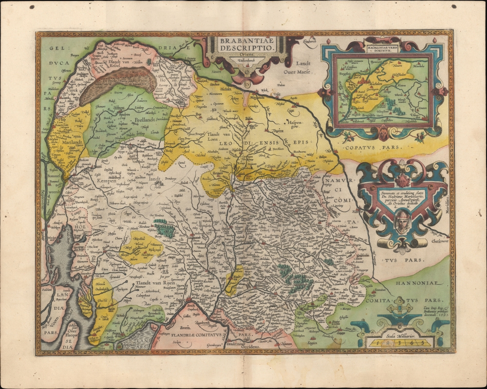
1595 Ortelius Map of Brabant, the Netherlands and Belgium
Brabant-ortelius-1595$800.00

Title
Brabantiae Descriptio.
1595 (undated) 14.75 x 19.75 in (37.465 x 50.165 cm) 1 : 400000
1595 (undated) 14.75 x 19.75 in (37.465 x 50.165 cm) 1 : 400000
Description
A beautiful original color example of Abraham Ortelius' 1595 map of Brabant, his home region, which contains the cities of Brussels and Antwerp. It appeared in his magisterial Theatrum Orbis Terrarum, the first modern atlas, first printed in Antwerp 1570.
Regions are labelled and in many cases color shaded for easy distinction. An inset at top-right displays the area around Machelen, seen on the main map shaded in yellow roughly halfway between Antwerp and Brussels. The region's intricate network of rivers, streams, and other waterways are cataloged, including the swampland of De Peel at top-left.
Four cartouches surround the title, inset map, publication information at right, and scale at bottom-right, while an intricate border surrounds the map. Text on the verso provides a historical and geographical description of Brabant.
Brabant as a whole was on the front lines of the conflict and was consequently divided in the eventual treaties which ended the war. North Brabant (Noord-Brabant) eventually became a province of the Dutch Republic while the remainder of the region remained part of the Habsburg Empire and later formed the northern portion of Belgium. The jagged and complex border between the two polities, which does not follow natural features between the Meuse and the North Sea, is best exemplified by the Dutch municipality of Baarle-Nassau, which includes 22 exclaves within the borders of the Belgian town of Baarle-Hertog, with some of those exclaves containing 'counter-enclaves' belonging to Belgium. The smallest of these is a mere 2,469 square meters or 26,580 sq. ft. and its boundary runs through the middle of a building, resulting in it having two addresses, one Dutch and one Belgian.
As with all Ortelius maps from the Theatrum, there can be considerable inconsistency and confusion in catalog listings. The OCLC independently catalogs one example of the map dated 1595 held by the Klassik Stiftung Weimar, though others may exist in institutional collections cataloged as 1591.
A Closer Look
This map oriented towards the east, with Antwerp towards bottom-left and Brussels to its right. The Meuse River runs in an arc along the top of the map, providing some helpful guidance to the modern viewer. Cities and towns are indicated throughout, with larger towns and cities represented by illustrations of buildings. Forests are likewise illustrated and shaded green.Regions are labelled and in many cases color shaded for easy distinction. An inset at top-right displays the area around Machelen, seen on the main map shaded in yellow roughly halfway between Antwerp and Brussels. The region's intricate network of rivers, streams, and other waterways are cataloged, including the swampland of De Peel at top-left.
Four cartouches surround the title, inset map, publication information at right, and scale at bottom-right, while an intricate border surrounds the map. Text on the verso provides a historical and geographical description of Brabant.
Historical Context
This map was published during the long struggle for Dutch independence from the Spanish empire known to history as the Eighty Years’ War (1568 - 1648). The opening phase of the conflict had been particularly unkind to the Brabant region, with its main urban center and capital of the Union of Utrecht (forerunner to the United Provinces and, eventually, the Dutch Republic), Antwerp, being sacked and terrorized by mutinying Spanish troops in 1576. The death and destruction were so severe the Antwerp's economic and cultural influence permanently declined relative to Amsterdam. A decade later, the city suffered a year-long siege that saw Spanish troops successfully capture Antwerp and expel Protestants over the next several years; many relocated to Amsterdam, again to the benefit of the latter. Even after the United Provinces were granted independence in 1648, the Scheldt River would remain closed for nearly two centuries afterwards, effectively precluding Antwerp from engaging in long distance trade.Brabant as a whole was on the front lines of the conflict and was consequently divided in the eventual treaties which ended the war. North Brabant (Noord-Brabant) eventually became a province of the Dutch Republic while the remainder of the region remained part of the Habsburg Empire and later formed the northern portion of Belgium. The jagged and complex border between the two polities, which does not follow natural features between the Meuse and the North Sea, is best exemplified by the Dutch municipality of Baarle-Nassau, which includes 22 exclaves within the borders of the Belgian town of Baarle-Hertog, with some of those exclaves containing 'counter-enclaves' belonging to Belgium. The smallest of these is a mere 2,469 square meters or 26,580 sq. ft. and its boundary runs through the middle of a building, resulting in it having two addresses, one Dutch and one Belgian.
Publication History and Census
Though dated 1591 at bottom-right, the present example conforms typographically to the 1595 Latin edition of the work. While the first edition of the Theatrum was released in 1570, Ortelius continually improved the work - both by adding new maps, and by refining the production of the book. Maps appearing in editions of the Theatrum in the 1580s and 1590s generally display, as here, a finer quality of color than those in the earlier issues of the work. The present map first appeared in the 1592 edition of the Theatrum.As with all Ortelius maps from the Theatrum, there can be considerable inconsistency and confusion in catalog listings. The OCLC independently catalogs one example of the map dated 1595 held by the Klassik Stiftung Weimar, though others may exist in institutional collections cataloged as 1591.
Cartographer
Abraham Ortelius (April 14, 1527 - June 28, 1598) also known as Ortels, was a cartographer, geographer, and cosmographer of Brabant, active in Antwerp. He was the creator of the first modern atlas, Theatrum Orbis Terrarum and is a seminal figure in the history of cartography. Along with Gerard Mercator and Gemma Frisius, he was a founder of the Netherlandish school of cartography. His connections with Spain - culminating in his 1575 appointment as Royal Cartographer to King Phillip II of Spain - gave him unmatched access to Spanish geographical knowledge during a crucial period of the Age of Discovery. Ortelius was born in 1527 in Antwerp. In 1547 he entered the Antwerp Guild of Saint Luke as an illuminator of maps. He began trading in books, prints, and maps, traveling regularly to the Frankfurt book and print fair, where in 1554 he met Mercator. He accompanied Mercator on journeys throughout France in 1560 and it was at this time, under Mercator's influence, that he appears to have chosen his career as a scientific geographer. His first published geographic work appeared in 1564, an eight-sheet cordiform world map. A handful of other maps preceded the 1570 publication of the first edition of the Theatrum Orbis Terrarum, which would prove to be his life work. Appearing with but 53 maps in its first edition, Ortelius' work expanded with new maps added regularly. By 1592, it had 134 maps. Many of Ortelius' maps remained the standard for nearly a century. He traveled extensively, but his genius was as a compiler, locating the best informed maps on which to base his own. His contacts throughout Europe and extending even (via the Portuguese) to the Far East were formidable. Moreover, many of his maps were based on his own scholarship, particularly his historical works. His theories of geography were particularly ahead of his time with respect to the notion of continental drift, the possibility of which he mused on as early as 1596, and which would be proven correct centuries later.
In a sense his greatest achievement was his successful navigation of the religious and political violence endemic to his city throughout his adult life: The Dutch Revolt, or Eighty Years' War (1568 - 1648), fully embroiled Antwerp. Although outwardly and officially recognized as Catholic (Arias Montanus vouched for Ortelius' Catholic orthodoxy prior to his appointment as Royal Geographer), Ortelius was able to separate himself from the religious furor which characterized the war in the low countries. Ortelius showed a glimpse of himself in a letter to a friend, regarding humanist Justus Lipsius: 'I do not know whether he is an adherent of the Pope or a Calvinist, but if he has ears to hear, he will neither be one nor the other, for sins are committed on both sides'. Ortelius' own explorations of Biblical history in his maps, and the Christogram contained in his own motto, suggest him to be a religious man, but his abjuration of political religious authorities mark him as an individualist. His tombstone at St Michael's Præmonstratensian Abbey in Antwerp bears the inscription, Quietis cultor sine lite, uxore, prole. ('served quietly, without accusation, wife, and offspring.') More by this mapmaker...
Source
Ortelius, A., Theatrum Orbis Terrarum, (Antwerp: Plantin) 1595.
Abraham Ortelius' magnum opus, Theatrum Orbis Terrarum, was the world's first regularly produced atlas, which 'set the standards for later atlases . . . It was the first undertaking of its kind to reduce the best available maps to an uniform format.' (Koeman) A modestly-sized work of fifty-three maps in its first edition of May 1570, it was an immediate success: there were three further editions that year, and the work remained in print for a total of 32 editions, the last of which was 1641, well after its author's 1598 death. Ortelius added to his atlas constantly, and by 1595 the Theatrum contained 147 maps. Ortelius is renowned generally as an editor, and indeed much of the Theatrum is compiled from a variety of sources: in such cases, Ortelius was scrupulous in naming his sources. But Ortelius was also a mapmaker in his own right: many of his maps are a distillation of various sources into his own work, and there were many maps - particularly in his atlas of Biblical and ancient history Parergon - which were entirely Ortelius' work. In his role as an editor, Ortelius followed in the footsteps of Munster, whose Cosmographia was, until Ortelius, the best window on the world for the curious European reader. In terms of the artistry of his maps, Ortelius oversaw the first great flourishing of copperplate engraving in the service of cartography to occur in Northern Europe. Ortelius' work provided the model for the atlases of Mercator, Hondius, Blaeu and all their progeny in the 17th century - many of whom were to produce faithful editions of Ortelius' maps in their own productions.
Condition
Very good. Generous margins. Superb original color. Slight foxing.
References
OCLC 551923506.