1774 Bonne Map of Southern Brazil, Northern Argentina, Uruguay and Paraguay
Brazil-bonne-1774$175.00
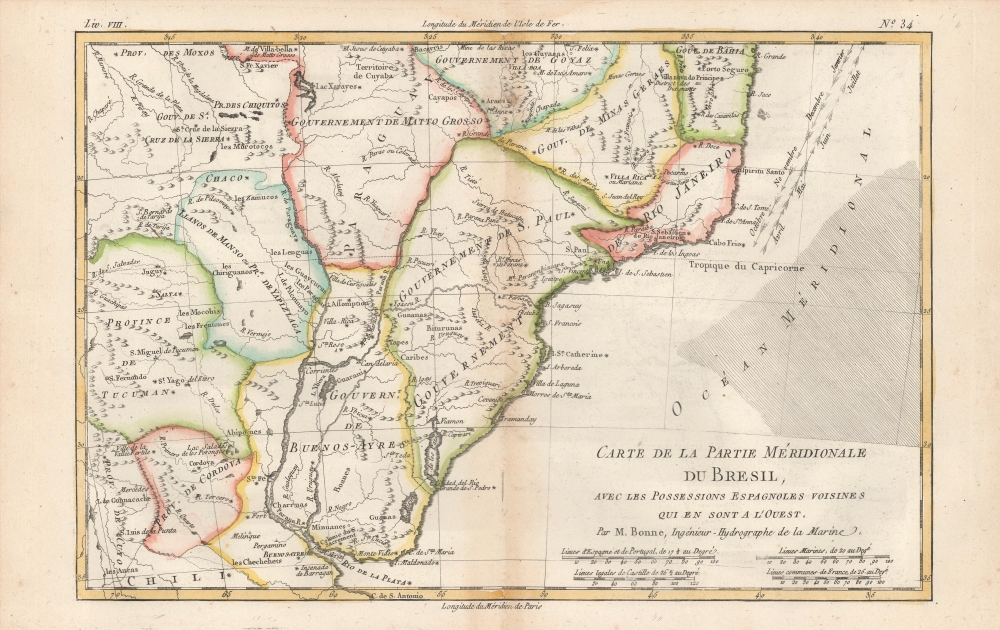

Title
Carte De La Partie Meridionale De Bresil, Avec Les Possessions Espagnoles Voisines que en sont a l'Ouest. Par M. Bonne, Ingénieur-Hydrographe de la Marine.
1774 (undated) 8.5 x 12.5 in (21.59 x 31.75 cm) 1 : 11500000
1774 (undated) 8.5 x 12.5 in (21.59 x 31.75 cm) 1 : 11500000
Description
An attractive example of Rigobert Bonne's 1774 map of southern Brazil, Uruguay, and northern Argentina, including Rio de Janeiro, Montevideo, and Buenos Aires. This map generally corresponds to modern day Minas Gerais, Sao Paulo, Parana, Santa Catarina, Rio Grande du Sol, Uruguay, Buenos Aires, Motto Grosso, and Paraguay. Offers speculative detail of the largely unexplored interior, including the Laguna de Xarayes, a mythical lake at the northern terminus of the Paraguay River associated with the Earthly Paradise.
Laguna de Xarayes
The mythical Laguna de Xarayes is illustrated here as the northern terminus, or source, of the Paraguay River. The Xarayes, a corruption of 'Xaraies' meaning 'Masters of the River', were an indigenous people occupying what are today parts of Brazil's Matte Grosso and the Pantanal. When Spanish and Portuguese explorers first navigated up the Paraguay River, as always in search of El Dorado, they encountered the vast Pantanal flood plain at the height of its annual inundation. Understandably misinterpreting the flood plain as a gigantic inland sea, they named it after the local inhabitants, the Xaraies. The Laguna de los Xarayes almost immediately began to appear on early maps of the region and, at the same time, to take on a legendary quality. Later missionaries and chroniclers, particularly Díaz de Guzman (1559 - 1629), imagined an island in this lake and curiously identified it as 'Island of Paradise,'...an island [of the Paraguay River] more than ten leagues [56 km] long, two or three [11-16 km] wide. A very mild land rich in a thousand types of wild fruit, among them grapes, pears and olives: the Indians created plantations throughout, and throughout the year sow and reap with no difference in winter or summer, ... the Indians of that island are of good will and are friends to the Spaniards; Orejón they call them, and they have their ears pierced with wheels of wood ... which occupy the entire hole. They live in round houses, not as a village, but each apart though keep up with each other in much peace and friendship. They called of old this island Land of Paradise for its abundance and wonderful qualities.
Publication History and Census
Drawn by R. Bonne for his Atlas De Toutes Les Parties Connues Du Globe Terrestre. The map appears on the market from time to time, but more frequently in later editions lacking Bonne's title as Ingénieur-Hydrographe de la Marine.Cartographer
Rigobert Bonne (October 6, 1727 - September 2, 1794) was one of the most important French cartographers of the late 18th century. Bonne was born in Ardennes à Raucourt, France. He taught himself mathematics and by eighteen was a working engineer. During the War of the Austrian Succession (1740 - 1748) he served as a military engineer at Berg-op-Zoom. It the subsequent years Bonne became one of the most respected masters of mathematics, physics, and geography in Paris. In 1773, Bonne succeeded Jacques-Nicolas Bellin as Royal Cartographer to France in the office of the Hydrographer at the Depôt de la Marine. Working in his official capacity, Bonne compiled some of the most detailed and accurate maps of the period - most on an equal-area projection known erroneously as the 'Bonne Projection.' Bonne's work represents an important step in the evolution of the cartographic ideology away from the decorative work of the 17th and early 18th century towards a more scientific and practical aesthetic. While mostly focusing on coastal regions, the work of Bonne is highly regarded for its detail, historical importance, and overall aesthetic appeal. Bonne died of edema in 1794, but his son Charles-Marie Rigobert Bonne continued to publish his work well after his death. More by this mapmaker...
Source
Bonne, R., Atlas De Toutes Les Parties Connues Du Globe Terrestre, (Paris) 1774.
Condition
Very good. Small mends at centerfold not impacting printed matter. Else excellent with full margins.