
This item below is out of stock, but another example (left) is available. To view the available item, click "Details."
Details
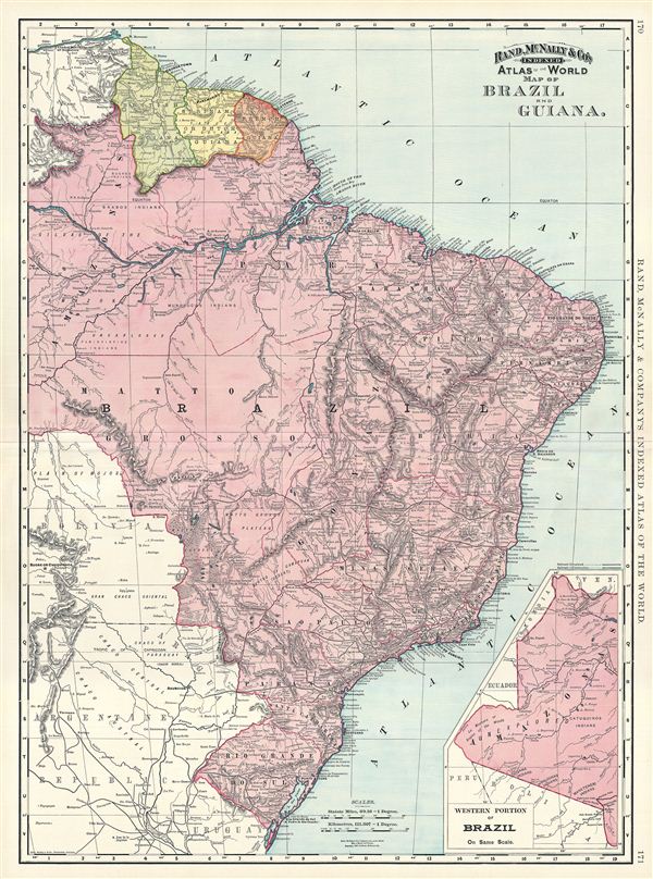
1892 Rand McNally Map of Brazil and Guiana
1892 (dated) $100.00
1892 Rand McNally Map of Brazil and Guiana
Brazil-randmcnally-1895$37.50

Title
Map of Brazil and Guiana.
1892 (dated) 27 x 20 in (68.58 x 50.8 cm) 1 : 7400000
1892 (dated) 27 x 20 in (68.58 x 50.8 cm) 1 : 7400000
Description
This is a beautiful example of Rand McNally and Company's 1892 map of Brazil and Guiana. It covers from the Orinoco River in Venezuela to Do Sul, including British, Dutch and French Guiana. In inset in the lower right quadrant details the western portion of Brazil. Part of neighboring Bolivia Paraguay, Argentina and Uruguay are also featured. This map was printed shortly after Brazil was declared a Republic following the abdication of Emperor Pedro II. Several Indian tribes are identified throughout. The Marshes of Xarayes are also identified. Color coded according to countries, the map notes several towns, cities, rivers, mountains, and various other topographical details with relief shown by hachure. This map was issued as plate nos. 170 and 171 in the 1895 issue of Rand McNally and Company's Indexed Atlas of the World - possibly the finest atlas Rand McNally ever issued.
Cartographer
Rand, McNally and Co. (fl. 1856 - present) is an American publisher of maps, atlases and globes. The company was founded in 1856 when William H. Rand, a native of Quincy, Massachusetts, opened a print shop in Chicago. Rand hired the recent Irish immigrant Andrew McNally to assist in the shop giving him a wage of 9 USD per week. The duo landed several important contracts, including the Tribune's (later renamed the Chicago Tribune) printing operation. In 1872, Rand McNally produced its first map, a railroad guide, using a new cost effective printing technique known as wax process engraving. As Chicago developed as a railway hub, the Rand firm, now incorporated as Rand McNally, began producing a wide array of railroad maps and guides. Over time, the firm expanded into atlases, globes, educational material, and general literature. By embracing the wax engraving process, Rand McNally was able to dominate the map and atlas market, pushing more traditional American lithographic publishers like Colton, Johnson, and Mitchell out of business. Eventually Rand McNally opened an annex office in New York City headed by Caleb S. Hammond, whose name is today synonymous with maps and atlases, and who later started his own map company, C. S. Hammond & Co. Both firms remain in business. More by this mapmaker...
Source
Rand McNally & Co., Foreign Countries. Rand, McNally & Co's Indexed Atlas of the World (Complete in Two Volumes)…, (Chicago) 1895.
Condition
Very good. Minor wear along original centerfold. Text on verso.
References
Rumsey 3565.046 (1897 edition). Philip (atlases) 1026 (1898 edition).