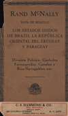
1924 Rand McNally Spanish-language Map of Brazil, Paraguay, Uruguay
Brazil-randmcnally-1924$450.00


Title
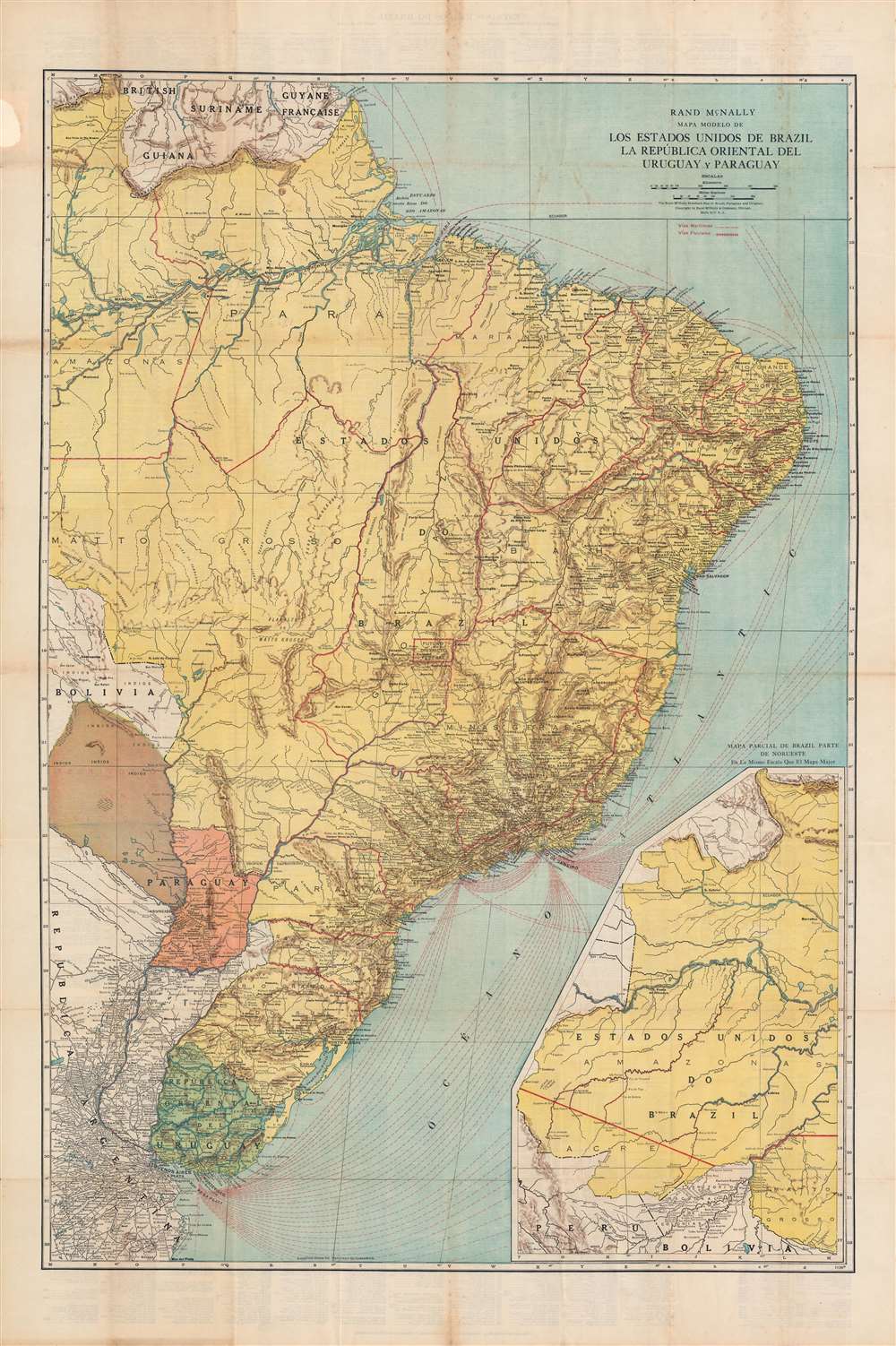
Mapa modelo de los Estados Unidos de Brazil, La República Oriental del Uruguay y Paraguay.
1924 (undated) 42 x 28 in (106.68 x 71.12 cm) 1 : 5020000
1924 (undated) 42 x 28 in (106.68 x 71.12 cm) 1 : 5020000
Description
This is a very rare Spanish-language c. 1924 Rand McNally map of Brazil, Paraguay, and Uruguay. It depicts the countries as they emerged from the wars and revolutions of the 19th century when they were contending with remnant territorial disputes and new revolutionary political forces.
The land to the left of the Paraguay River at bottom-left marked as 'territory in litigation' is the northern part of the Gran Chaco region, now the western half of Paraguay. The area had been disputed for years between Bolivia and Paraguay, a conflict that was only (partially) settled in the Chaco War of 1932 - 1935. Paraguay effectively won the war, but it was very costly to both countries, becoming the bloodiest conflict in 20th century South America. The war had been sparked by the belief that Gran Chaco was sitting on top of immense oil reserves. After the war, no such reserves were found, making the entire episode that much more unfortunate, although both countries have discovered and exploited oil reserves in the region in the past decade.
Near the center of the map, and of Brazil, is an area designated as 'Future Federal District.' As the country's wealth and political power was concentrated in the southeast (Sao Paolo and Rio de Janeiro), proposals had long been made for building a capital near the geographic center of the country, and this measure had even been written into the country's first republican constitution in 1891. Finally, in the late 1950s, Brasilia was constructed under the presidency of Juscelino Kubitschek. As an entirely planned city, it is a fascinating case study of urban design and architecture. Since its founding, Brasilia has developed rapidly and become the wealthiest city in Brazil and in Latin America more broadly on a per capita basis.
These elements added up to a volatile situation, and unrest, even uprisings, were common during the First Republic. When the election of 1930 divided the elite, conflict broke out and the military seized power, installing as President Getúlio Vargas, one of the key figures of 20th century Latin American populism. His Estado Novo system was influenced by European fascism, combining corporatism, nationalism, dictatorship, and suppression of political opposition, especially from the left-wing (though Brazil did eventually join the Allied side in the Second World War).
Uruguay and Paraguay were also riven by similar political forces, with contention between entrenched wealthy landowners, reformist liberals, would-be dictators in the military, and radical revolutionaries. In Uruguay, the result was the long dominance of politics by José Batlle y Ordóñez and his allies. Championing the rights of commoners over wealthy landed interests, Batlle pursued a range of progressive policies that made Uruguay a model for the development of education, health, social welfare, and workers' rights. However, this system ran into serious problems with the Great Depression, resulting in a military coup and nearly ten years of dictatorship.
Landlocked Paraguay was in a more difficult situation, suffering from poverty, political instability, and the effects of the aforementioned Chaco War. In the aftermath of the war, the military overthrew the government in February 1936, briefly bringing to power Rafael Franco, a populist dictator, who was himself overthrown the following year by a right-wing faction in the military.
A Closer Look
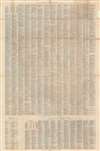
The map illustrates administrative divisions, geographical features, and transportation lines for Brazil, Uruguay, and Paraguay. A grid system of letters and numbers corresponds to an extremely detailed index of states, cities, and towns on the back (verso), noting the presence of post offices, train stations, and the population where known. A large inset at bottom-right displays the northwestern territories of Brazil, deep in the Amazon rainforest.The land to the left of the Paraguay River at bottom-left marked as 'territory in litigation' is the northern part of the Gran Chaco region, now the western half of Paraguay. The area had been disputed for years between Bolivia and Paraguay, a conflict that was only (partially) settled in the Chaco War of 1932 - 1935. Paraguay effectively won the war, but it was very costly to both countries, becoming the bloodiest conflict in 20th century South America. The war had been sparked by the belief that Gran Chaco was sitting on top of immense oil reserves. After the war, no such reserves were found, making the entire episode that much more unfortunate, although both countries have discovered and exploited oil reserves in the region in the past decade.
Near the center of the map, and of Brazil, is an area designated as 'Future Federal District.' As the country's wealth and political power was concentrated in the southeast (Sao Paolo and Rio de Janeiro), proposals had long been made for building a capital near the geographic center of the country, and this measure had even been written into the country's first republican constitution in 1891. Finally, in the late 1950s, Brasilia was constructed under the presidency of Juscelino Kubitschek. As an entirely planned city, it is a fascinating case study of urban design and architecture. Since its founding, Brasilia has developed rapidly and become the wealthiest city in Brazil and in Latin America more broadly on a per capita basis.
From Monarchy to Republic to Populism
This map was made during the latter part of the First Brazilian Republic, also known as the 'Old Republic,' which overthrew the elderly Emperor Pedro II in 1889. In this period, Brazilian politics was effectively an oligarchy dominated by large landholding interests, particularly the coffee and dairy industries, based in São Paulo and Minas Gerais, respectively (leading to the phrase 'coffee with milk politics'). Most of the population was poor and illiterate, working on plantations or ranches producing goods (coffee, sugar, cotton) for export, and society was highly stratified (slavery was only abolished in 1888). As is suggested by the shipping lines illustrated here, Brazil's economy consisted of several distinct regional economies that were more integrated with foreign markets than with each other. Meanwhile, radical socialist, communist, and anarchist movements from Europe spread to Brazil, promising the toiling masses a better future.These elements added up to a volatile situation, and unrest, even uprisings, were common during the First Republic. When the election of 1930 divided the elite, conflict broke out and the military seized power, installing as President Getúlio Vargas, one of the key figures of 20th century Latin American populism. His Estado Novo system was influenced by European fascism, combining corporatism, nationalism, dictatorship, and suppression of political opposition, especially from the left-wing (though Brazil did eventually join the Allied side in the Second World War).
Uruguay and Paraguay were also riven by similar political forces, with contention between entrenched wealthy landowners, reformist liberals, would-be dictators in the military, and radical revolutionaries. In Uruguay, the result was the long dominance of politics by José Batlle y Ordóñez and his allies. Championing the rights of commoners over wealthy landed interests, Batlle pursued a range of progressive policies that made Uruguay a model for the development of education, health, social welfare, and workers' rights. However, this system ran into serious problems with the Great Depression, resulting in a military coup and nearly ten years of dictatorship.
Landlocked Paraguay was in a more difficult situation, suffering from poverty, political instability, and the effects of the aforementioned Chaco War. In the aftermath of the war, the military overthrew the government in February 1936, briefly bringing to power Rafael Franco, a populist dictator, who was himself overthrown the following year by a right-wing faction in the military.
Publication History and Census
This map was published by Rand McNally in Chicago, based on their English-language 'Rand McNally standard map of Brazil, Paraguay, and Uruguay.' Though the map is undated, contextual evidence suggests that it dates from the mid-1920s, and the English-language edition appeared in the 1924 edition of Rand McNally's Commercial Atlas of America. The Spanish edition is especially rare, with only one example in the OCLC and no known history on the market.Cartographer
Rand, McNally and Co. (fl. 1856 - present) is an American publisher of maps, atlases and globes. The company was founded in 1856 when William H. Rand, a native of Quincy, Massachusetts, opened a print shop in Chicago. Rand hired the recent Irish immigrant Andrew McNally to assist in the shop giving him a wage of 9 USD per week. The duo landed several important contracts, including the Tribune's (later renamed the Chicago Tribune) printing operation. In 1872, Rand McNally produced its first map, a railroad guide, using a new cost effective printing technique known as wax process engraving. As Chicago developed as a railway hub, the Rand firm, now incorporated as Rand McNally, began producing a wide array of railroad maps and guides. Over time, the firm expanded into atlases, globes, educational material, and general literature. By embracing the wax engraving process, Rand McNally was able to dominate the map and atlas market, pushing more traditional American lithographic publishers like Colton, Johnson, and Mitchell out of business. Eventually Rand McNally opened an annex office in New York City headed by Caleb S. Hammond, whose name is today synonymous with maps and atlases, and who later started his own map company, C. S. Hammond & Co. Both firms remain in business. More by this mapmaker...
Condition
Very good. Slight discoloration along fold lines and in upper-left margin.
References
OCLC 227493096.