This item has been sold, but you can get on the Waitlist to be notified if another example becomes available, or purchase a digital scan.
1889 Rand McNally Map of Brevard County, Florida
BrevardCountyFL-randmcnally-1889$50.00

Title
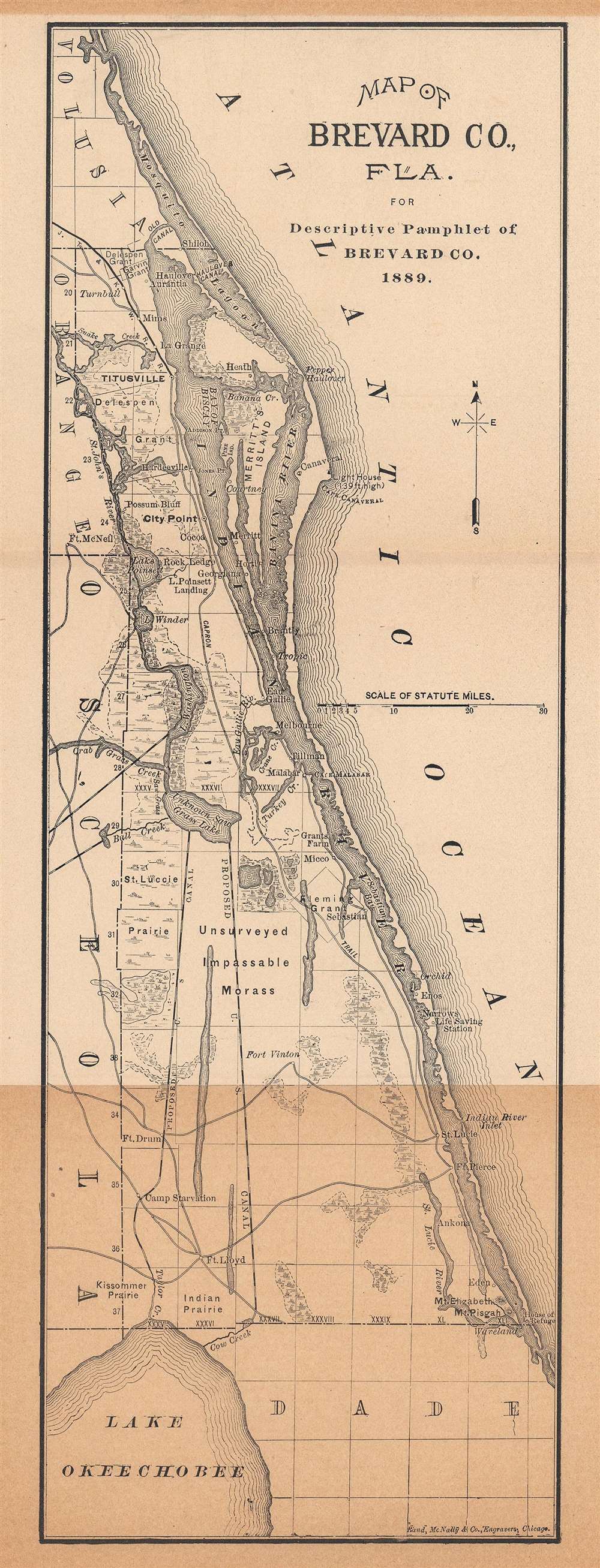
Map of Brevard Co., Fla. for Descriptive Pamphlet of Brevard Co.
1889 (dated) 14 x 5 in (35.56 x 12.7 cm) 1 : 950400
1889 (dated) 14 x 5 in (35.56 x 12.7 cm) 1 : 950400
Description
This is an 1889 Rand McNally and Company map of Brevard County, Florida. Coverage extends from Mosquito Lagoon south along the Florida Atlantic coast to Dade County and Lake Okeechobee (further inland). Titusville, the terminus of the Jacksonville, Tampa, and Key West Railroad, appears in bold print with the railroad heading to the northwest. Cape Canaveral is labeled. Two proposed canal routes from Unknown Saw Grass Lake and Lake Okeechobee are illustrated by black and white dashed lines. Several forts are identified in the southwest corner of Brevard County. An 'unsurveyed impassable morass' occupies part of the central portion of the county next to the Fleming Grant. The Capron Trail appears near the bank of the Indian River and traverses almost the entirety of Brevard County.
The Fleming Grant
This large grant on both sides of the St. Sebastian River was awarded to George Fleming, an Irishman who served in the Spanish Army, in 1816. The entire grant was purchased in 1892 by James W. Todd, a member of the Board of Directors at Bissell's Bank. Todd broke up the Fleming Grant and appears to have sold the last of it in 1910.Publication History and Census
This map was created by Rand McNally and Company and published in A Brief Description of Brevard County, Florida, or the Indian River Country; its Climate, Health, Products, Etc. in 1889. The present example was published in the third edition of the pamphlet in 1890. We note a single example of the separate map in OCLC, located at the Jacksonville Public Library. Perhaps a dozen examples of the 1889 and 1890 editions of the pamphlet are cataloged in institutional collections.Cartographer
Rand, McNally and Co. (fl. 1856 - present) is an American publisher of maps, atlases and globes. The company was founded in 1856 when William H. Rand, a native of Quincy, Massachusetts, opened a print shop in Chicago. Rand hired the recent Irish immigrant Andrew McNally to assist in the shop giving him a wage of 9 USD per week. The duo landed several important contracts, including the Tribune's (later renamed the Chicago Tribune) printing operation. In 1872, Rand McNally produced its first map, a railroad guide, using a new cost effective printing technique known as wax process engraving. As Chicago developed as a railway hub, the Rand firm, now incorporated as Rand McNally, began producing a wide array of railroad maps and guides. Over time, the firm expanded into atlases, globes, educational material, and general literature. By embracing the wax engraving process, Rand McNally was able to dominate the map and atlas market, pushing more traditional American lithographic publishers like Colton, Johnson, and Mitchell out of business. Eventually Rand McNally opened an annex office in New York City headed by Caleb S. Hammond, whose name is today synonymous with maps and atlases, and who later started his own map company, C. S. Hammond & Co. Both firms remain in business. More by this mapmaker...
Source
Brevard County Commissioners, A Brief Description of Brevard County, Florida, or the Indian River Country; its Climate, Health, Products, Etc., 3rd Edition., (Jacksonville: Times-Union Publishing House) 1890.
Condition
Good. Light wear along original fold lines. Unusual fold metric has led to additional toning in lower third of map.
References
OCLC 946614437.