
1940 Los Angeles Examiner Pictorial Map of a Possible Nazi Attack on Britain

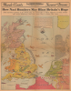
How Nazi Bombers May Blast Britain's Hope.
A possible Nazi bombardment of England - before the May 1940 invasion of Western Europe.
- Digital Map Information
- Suitable for large format printing
- Full resolution TIFF file
- ICC color profile embedded
- Delivered instantly via download link
A possible Nazi bombardment of England - before the May 1940 invasion of Western Europe.
This is a 1940 Los Angeles Examiner pictorial map of England, Scotland, Wales, and the northern coast of Europe. Published on March 31, 1940, over a month before the Nazi invasion of Western Europe, the map speculates on a possible Nazi offensive against Britain and what the targets might be.A Closer Look
The map depicts the region from Belfast, Ireland, to Norway and from the Orkney Islands to France, Belgium, the Netherlands, and Germany. Published before the Nazi invasion in May 1940, everything illustrated here reflected assumptions about Hitler's next move. The distances provided clearly indicate that targets throughout England and Scotland fell well within the range of German bombers based in Germany, creating 'a ready target for German bombs.' Some of the presumed targets are labeled as having been bombed in the 'World War', meaning the Great War, which ended less than two decades prior.Highly detailed and extremely graphic, the focal point is an English civil defenseman manning an anti-aircraft gun against the coming onslaught. Numerous cities in England, Scotland, and Wales are labeled, including London (with a nice profile illustration of St. Paul's Cathedral), Birmingham, Liverpool, Edinburgh, Glasgow, and Cardiff. Natural resources found on the British Isles, such as wheat, barley, iron, and coal, are also labeled. Mine fields are illustrated along the eastern coast of England and between Dover and Calais, France.
Publication History and Census
This map was copyrighted by the Los Angeles Examiner and published on March 31, 1940. Papers across the country subsequently published this map in their editions. We know of only a handful of surviving examples.Cartographer
Herbert Edward Floercky (fl. c. 1929 - 1933) was a California-based geographer, cartographer, and illustrator. An engineer by training, he turned to maps after the stock market crash of 1929. He is best known for this 1929 'Amusement Map of Los Angeles County' and his popular, richly-illustrated 1933 book A Visual Geography of California, originally drawn and written for his own children, which became a textbook in the state's schools. Further Details...
Condition
Good. Wear and toning along original fold lines. Verso repairs to fold separations and at fold intersection. Closed tear extending 1.5 inches within printed area professionally repaired on verso. Closed edge tears professionally repaired on verso. Text and printed images on verso.