
This item below is out of stock, but another example (left) is available. To view the available item, click "Details."
Details
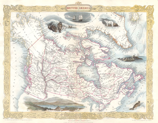
1851 Tallis Map of Canada or British America
1851 (undated) $275.00
1849 Tallis Map of Canada or British America w/ Oregon
BritishAmerica-tlls-1849$125.00

Title
British America.
1849 (undated) 10 x 13 in (25.4 x 33.02 cm)
1849 (undated) 10 x 13 in (25.4 x 33.02 cm)
Description
This is a rare and curious first state first edition of Tallis's 1849 map of British America or what is today Canada. Extends from Russian America ( Alaska ) east as far as Greenland and Iceland. Inexplicably, this map recognizes the British claim to Oregon as far south as the Columbia River. This dispute was supposedly resolved three years previously in 1846 by the 'Oregon Treaty' which officially set the U.S – British America border at the 49th parallel. Features numerous decorative vignettes typical of Rapkin / Tallis work including a seal, whale fishing, the exploring ships Fury and Recla, a polar bear, some Esquimaux (Eskimos) and a view of Boston. Later versions of this map would replace the Boston view and update the political geography of the Oregon region (called New Georgia here). This particular version never made it into the Tallis's important 1850 atlas, instead it was issued exclusively for the 1849 edition of Hinton's History and Topography of the United States. The illustrations are by H. Warren and engraved by R. Wallis; the map is drawn and engraved by J. Rapkin. Published by the John Tallis & Company, London & New York in 1850-1852.
Cartographer
John Tallis and Company (1838 - 1851) published views, maps, and atlases in London from roughly 1838 to 1851. Their principal works, expanding upon the earlier maps of John Cary and Aaron Arrowsmith, include an 1838 collection of London Street Views and the 1849 Illustrated Atlas of the World. The firm’s primary engraver was John Rapkin, whose name and decorative vignettes appear on most Tallis maps. Due to the embellishments typical of Rapkin's work, many regard Tallis maps as the last bastion of English decorative cartography in the 19th century. Although most Tallis maps were originally issued uncolored, it was not uncommon for 19th century libraries to commission colorists to "complete" the atlas. The London Printing and Publishing Company of London and New York bought the rights for many Tallis maps in 1850 and continued issuing his Illustrated Atlas of the World until the mid-1850s. Specific Tallis maps later appeared in innumerable mid to late-19th century publications as illustrations and appendices. More by this mapmaker...
Source
Hinton’s History and Topography of the United States., (1849 edition).
Condition
Fine or perfect condition. Blank on verso.
References
Rumsey 0466.067. Phillips 804-6. Hinton, John Howard, The History and Topography of The United States of North America From The Earliest Period To The Present Time, 1849.