This item has been sold, but you can get on the Waitlist to be notified if another example becomes available, or purchase a digital scan.
1755 Le Rouge Map of the English Colonies in North America (Eastern Seaboard)
BritishColoniesAmerica-lerouge-1755$1,375.00

Title
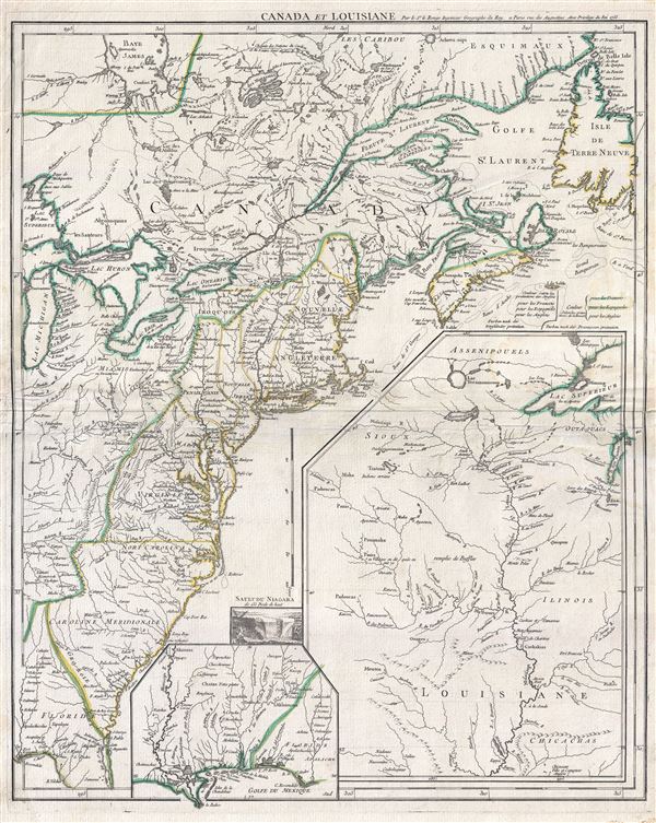
Canada et Louisiane.
1755 (dated) 25 x 20 in (63.5 x 50.8 cm) 1 : 4400000
1755 (dated) 25 x 20 in (63.5 x 50.8 cm) 1 : 4400000
Description
A scarce 1755 map of the eastern part of North America by Georges-Louis Le Rouge. This important map was issued in the second year of the French and Indian War. Centered on the British colonies in North America, the main map covers from Lake Michigan (Chicago) to the eastern seaboard and from James Bay (Hudson Bay) to the Gulf of Mexico. Large insets further extend the map westward to cover the Upper Mississippi River Valley, the Lower Mississippi Valley, and the Gulf Coast in the vicinity of New Orleans. Spanish territory is identified in green, French in blue, and English in yellow.
Le Rouge issued this influential and popular map in the early days of the French and Indian War when the French, having won every major battle, seemed assured of victory. The map reflects an idealized and Franco-centric perspective on the region, with the British colonies restricted to the eastern flanks of Appalachian Mountains, and the southern parts of Nova Scotia and Newfoundland. All five of the Great Lakes as well as the important St. Lawrence and Lake Champlain arteries fall well into French territory. The site of the Braddock's disastrous attack on Fort Duquesne is identified as is the site of George Washington's primitive construction of Fort Necessity. Curiously the cartographer seems unsure of the location of Fort Duquesne and places it twice: a northerly site following the French cartographer J. B. B. D'Anville, and a more southerly site referencing the British cartographer Thomas Jefferys. On Lake George, the cartographer notes the 1755 Battle of Crown Point, a failed attempt by British officer William Johnson to seize Fort. St. Frederic and thus set the stage to undermine French control of Canada.
The maps' two insets focus on French territory in Louisiana from New Orleans to the Upper Mississippi Valley. Numerous French fortifications are identified throughout and though most of these were little more than fur trading outposts, their presence on the map is intended to reinforce the impression of French control and occupation. So too is the liberal identification of various indigenous American Indian groups and mineral deposits throughout, a clear indicator in the eyes of the European citizenry of national hegemony throughout a territory. A vignette set just off the Carolina Outer Banks illustrates Niagara Falls, then a remote wonder popular with European mapmakers and a curiosity for the general public. Also of note is the uncommon vertically oriented mileage scale presented just above the Niagara vignette.
The present example represents this map in its first edition, 1755. In 1777 it was subsequently reworked to accommodate the nascent United States and retitled it Theatre de la guerre en Amerique. It was revised again in 1787 shortly after the finish of the American Revolutionary War.
Cartographer
Georges-Louis Le Rouge (c. 1707 - c. 1790) was a Paris based map publisher operating in the middle part of the 18th century. Le Rouge was born in Hanover Germany as Georg Ludwig, where he was educated and employed as a military engineer and surveyor. His father may have been the French architect Louis Remy de la Fosse (1659 - 1726), which would explain his early education in both engineering and draftsmanship. He assisted his father on a large-scale plan of Darmstadt, which he completed following his father's death in 1726. He may have remained in Darmstadt, but little is known of his life from 1726 - 1736, when he appears in Paris. Le Rouge acquired a position as military and civil engineer for King Louis XV and Louis XVI. Around this time, he Francophied his name to 'Le Rouge'. In 1840, he set up shop on the Rue Des Grands Augustins as an engraver, book publisher, and map publisher. He partnered with the English cartographer and engineer John Rocque (1709 - 1762), who became an important source for English maps, which Le Rouge re-engraved for French use. Despite being born German and adopting Paris as his home, Le Rouge was an ardent Anglophile and spent much of his time translating English books and maps into French. During his active period of roughly forty years Le Rouge produced thousands of maps and diagrams ranging from city and town plans, to atlases, plans of military campaigns and sea charts. He was a friend and correspondent of Benjamin Franklin (1706 - 1790), with whom he produced the important 1769 Franklin/Folger Map of the Gulf Stream. Franklin, who met Le Rouge in Paris, writes that 'He [Le Rouge] is, I believe, a proper person.' He was awarded for his diligence with the impressive but unstipended honorific 'Geographe du Roi'. They may not have served him swell during the French Revolution (1789 - 1799), as his last known work was published in 1789, just before the storming of the Bastille. The exact date of Le Rouge's death remains a mystery. By most estimates, he is believed to have been alive in 1790, but may have lived as long as 1794. More by this mapmaker...
Condition
Good. Minor wear along original fold line. Extremely minor water satin, almost invisible.
References
OCLC 165868938.