This item has been sold, but you can get on the Waitlist to be notified if another example becomes available, or purchase a digital scan.
1817 Thomson Map of India with Nepal (set of 2 maps)
BritishIndia-thomson-1817$200.00

Title
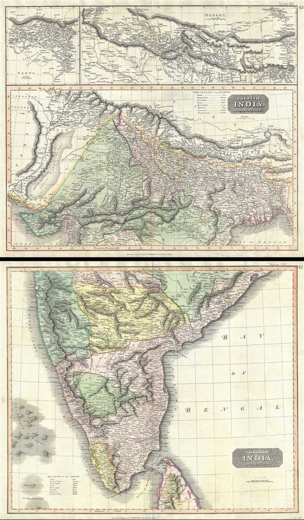
British India, Northern Part. British India, Southern Part.
1817 (undated) 41 x 25 in (104.14 x 63.5 cm) 1 : 4400000
1817 (undated) 41 x 25 in (104.14 x 63.5 cm) 1 : 4400000
Description
This is a fascinating hand colored set of the 1817 maps by Edinburgh cartographer John Thomson depicting India and Nepal. Essentially two separate maps, the first map (image top) depicts northern India and Nepal bounded on the east by Persia and the Indus valley, on the North by Tibet, on the south by Berar, and on the east by Assam and Bhutan. Much of the upper portion of this map includes a detailed inset of the Kingdom of Nepal or Nepaul. This area is depicted in impressive detail considering that, when this map was printed very few western travelers had ever been to Nepal. Includes roads, mountain passes and the residences of important Lamas. Extends fully into the Tibetan plateau as far as Te Shoo Loomboo and the Road to Lhasa (Lassa). The top left quadrant of this map contains an inset of Kabul or Cabul.
The second map (image bottom) covers southern India from Bombay in the North to the northern part of Ceylon or Sir Lanka. On both maps, British controlled areas are red, the territory of Nabob of Oude is orange, the Berar Rajah is green, the regions controlled by the King of Candy are brown, etc. Overall a set spectacularly highly detailed maps of this fascinating region and one of the finest maps of India to appear in the 19th century. Prepared by John Thomson for inclusion in the 1817 edition of Thomson's New General Atlas. Note; The image above represents two separate sheets.
The second map (image bottom) covers southern India from Bombay in the North to the northern part of Ceylon or Sir Lanka. On both maps, British controlled areas are red, the territory of Nabob of Oude is orange, the Berar Rajah is green, the regions controlled by the King of Candy are brown, etc. Overall a set spectacularly highly detailed maps of this fascinating region and one of the finest maps of India to appear in the 19th century. Prepared by John Thomson for inclusion in the 1817 edition of Thomson's New General Atlas. Note; The image above represents two separate sheets.
Cartographer
John Thomson (1777 - c. 1841) was a Scottish cartographer, publisher, and bookbinder active in Edinburgh during the early part of the 19th century. Thomson apprenticed under Edinburgh bookbinder Robert Alison. After his apprenticeship, he briefly went into business with Abraham Thomson. Later, the two parted ways, John Thomson segueing into maps and Abraham Thomson taking over the bookbinding portion of the business. Thomson is generally one of the leading publishers in the Edinburgh school of cartography, which flourished from roughly 1800 to 1830. Thomson and his contemporaries (Pinkerton and Cary) redefined European cartography by abandoning typical 18th-century decorative elements such as elaborate title cartouches and fantastic beasts in favor of detail and accuracy. Thomson's principle works include Thomson's New General Atlas, published from 1814 to 1821, the New Classical and Historical Atlas of 1829, and his 1830 Atlas of Scotland. The Atlas of Scotland, a work of groundbreaking detail and dedication, would eventually bankrupt the Thomson firm in 1830, at which time their plates were sequestered by the court. The firm partially recovered in the subsequent year, allowing Thomson to reclaim his printing plates in 1831, but filed again for bankruptcy in 1835, at which time most of his printing plates were sold to A. K. Johnston and Company. There is some suggestion that he continued to work as a bookbinder until 1841. Today, Thomson maps are becoming increasingly rare as they are highly admired for their impressive size, vivid hand coloration, and superb detail. More by this mapmaker...
Source
Thomson, J., A New General Atlas, (Edinburgh) 1817.
Thomson's New General Atlas was first published in 1817 and continued to be published until about 1821. This is the first of Thomson's major cartographic works and the atlas for which is most celebrated. The New General Atlas follows in the Edinburgh School, which eschews excessive decoration in favor of a more minimalistic fact-based cartographic vision, as established by John Pinkerton, Laurie and Whittle, John Cary, and others in the previous decades. The maps are notable for their massive scale, heavy stock, elegant color work, and easy-to-read typefaces. Although the atlas stopped being published after 1821, Thomson continued to offer 'supplementary' maps that could be tipped into the atlas as late as 1830, when he declared bankruptcy. The maps in the Thomson Atlas were engraved by Thomas Clerk, William Dassauville, Nathaniel Rogers Hewitt, James Kirkwood, Robert Kirkwood, John Menzies, George Menzies, Edward Mitchell, John Moffatt, Samuel John Neele, Robert Scott, and James Wyld.
Condition
Very good. Set of two maps. Minor wear and verso repair along original centerfolds. Original platemarks visible. Foxing and toning at places.
References
Rumsey 1007.045, 1007.046.