This item has been sold, but you can get on the Waitlist to be notified if another example becomes available, or purchase a digital scan.
1690 De Wit Map of the British Isles: England, Scotland, Ireland
BritishIsles-dewit-1690$325.00

Title
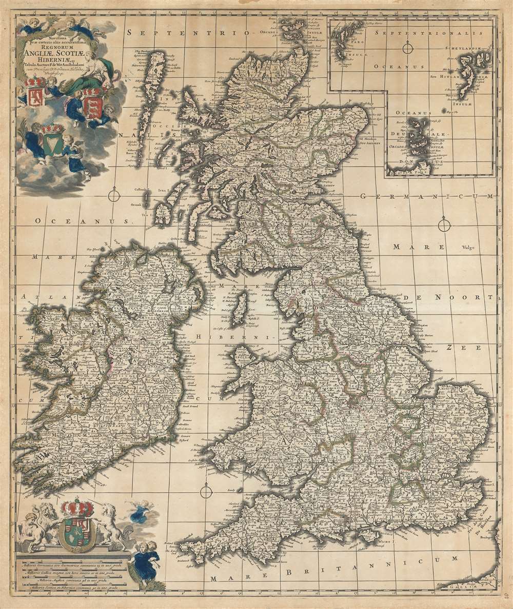
Novissima prae caeteris aliis accuratissima regnorum Angliae, Scotiae, Hiberniae.
1690 (undated) 24 x 20.25 in (60.96 x 51.435 cm) 1 : 800000
1690 (undated) 24 x 20.25 in (60.96 x 51.435 cm) 1 : 800000
Description
An impressive c. 1690 Dutch Golden Age map of the British Isles by Frederick de Wit. The map including England, Scotland, Wales, and Ireland, as well as an inset of the Faro, Shetland and Orkney Islands. The title cartouche, appearing in the upper left, is surrounded by clouds in which putti display the coats of arms of England, Scotland and Ireland. The scale of miles, appearing in the lower left, is further embellished with the royal joint-sovereignty coat of arms of William and Mary (1689-94).
Publication History and Census
This map was engraved and drafted by Frederick de Wit in Amsterdam. It was subsequently copied with slight variations by other cartographers of the period, including Nicolaes Visscher, Petrus Schenck, Matthaeus Seutter, J. B. Homann, and others. There were at least two states that appeared in various composite atlases of the late 17th century. The map appears relatively rarely on the market.Cartographer
Frederik de Wit (1629 - 1706) was a Dutch Golden Age cartographer active in the second half of the 17th and the early 18th centuries. De Wit was born of middle class Protestant stock in the western Netherlandish town of Gouda. He relocated to Amsterdam sometime before 1648, where he worked under Willem Blaeu. His first attributed engraved map, a plan of Haarlem for Antonius Sanderus' Flandria Illustrata, was issued around this time. He struck out on his own in 1654. The first chart that De Wit personally both drew and engraved was most likely his 1659 map of Denmark, REGNI DANIÆ Accuratissima delineatio Perfeckte Kaerte van ‘t CONJNCKRYCK DENEMARCKEN. His great wall map of the world and most famous work, Nova Totius Terrarum Orbis Tabula appeared one year later. Following the publication of his wall map De Wit quickly rose in prominence as a both cartographer and engraver. He married Maria van der Way in 1661 and through her became a citizen of Amsterdam in 1662. Around this time he also published his first major atlas, a composite production ranging in size from 17 to over 150 maps and charts. Other atlases and individual maps followed. In 1689 De Wit was granted a 15 year Privilege by the Dutch States General. (An early copyright that protected the recipient's rights to print and publish.) He was recognized with the honorific 'Good Citizen' in 1694. De Wit died in 1706 after which his wife Maria continued publishing his maps until about 1710. De Wit's son, Franciscus, had no interest in the map trade, instead choosing to prosper as a stockfish merchant. On her own retirement, Maria sold most De Wit maps and plates at a public auction. Most were acquired by Pieter Mortier and laid the groundwork for the 1721 rise of Covens and Mortier, the largest Dutch cartographic publishing house of the 18th century. More by this mapmaker...
Condition
Good. Overall toning. Old color. Blank on verso.
References
OCLC 71416504.