1639 Van Lochom Map of the British Isles - rare!
BritishIsles-vanlochom-1639-2$3,500.00

Title
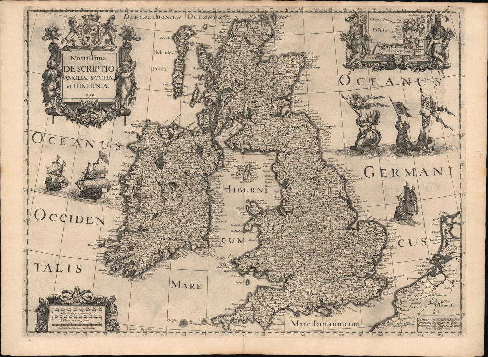
Novissima descriptio Angliae Scotiae et Hiberniae.
1639 (dated) 14.5 x 19.75 in (36.83 x 50.165 cm) 1 : 2344320
1639 (dated) 14.5 x 19.75 in (36.83 x 50.165 cm) 1 : 2344320
Description
This is a rare, separately-issued map of the British Isles, engraved in 1639 by Michel van Lochom. It is a French engraved-and-printed iteration of the finest Dutch map of the Isles of that era, Henry Hondius' Magnae Britanniae et Hibernieae Tabula. The superb work of van Lochom's engraver Henry le Roy shows the rapid development of French map engraving in its cradle period.
A Closer Look
Centered on the Irish Sea, the map extends to cover all of the British Isles, including England, Scotland, Wales, and Ireland. There is an inset map of the Orkney Islands in the upper right. The Wall of Hadrian, fortifications built by the Roman Empire to defend against the unruly tribes of the north, separates England and Scotland. While similar geographically to Blaeu's contemporaneous map, itself engraved by Jodocus Hondius, the lavish decoration of the map identifies its source as the map of Henry Hondius. Van Lochom reprises Hondius' sailing ships, as well as the trio of mermaids displaying the British and Irish coats of arms. The putti-flanked Orkney inset and cartouche, as well as the map's scales, are all beautifully framed.Publication History and Census
Van Lochom's map was engraved by Henry le Roy; van Lochom did not have a dedicated atlas, and his maps were sold as separate issues or destined for composite atlases; hence their rarity. We see this map in only three institutional collections: the Bibliothèque Nationale de France, the British Library, and the National Library of Scotland. It is scarce on the market.CartographerS
Michel van Lochom (April 28, 1601 - January 23, 1647) was a Calvinist Flemish engraver active in Antwerp and Paris during the first half of the 17th century. Van Lochom was born in Antwerp, the son of Hans van Lochom, also an engraver, and Clara Janssens. He mastered engraving under the tutelage of his father and in 1613 joined the Antwerp branch of the Guild of St. Luke (a artist and printers guild). As part of the guild he trained under Abraham van Merlen (1579-1660), a Flemish painter and engraver. Van Lochom became a master in the guild in 1621. Four years later, in 1625 he relocated to Paris where is established himself as a painter and engraver. He may have relocated to Paris in order to marry Marguerite Lenoir, the daughter of the prominent Paris bookseller Guillaume Lenoir, and sister-in-law to Pierre Mariette via her sister Geneviève Lenoir. Attaining some prominence engraving religious portraits, Van Lochom was awarded the title of Graveur et Imprimeur du Roy. His address, in 1836, was St Jacques à la Rose Blanche Couronnée, Paris. He remained in Paris until his death in 1647. After his death, his widow sold some 3000 pounds of printing plates to Balthasar Moncornet. His remaining stock went to Pierre Mariette who may have owned part of Lochom's business. Lochom is alternatively known as Lochum or Lochem. More by this mapmaker...
Henry Le Roy (1579 - November 20, 1651) was a Dutch goldsmith, engraver, and printer active in Paris during the first half of the 17th century. Le Roy was born in Rotterdam and moved to Paris in around the turn of the century. He is best known for his avian and botanical imagery, which is reminiscent of Hollar, but did engrave a few maps with Michel van Lochom, and others. He is interred at the Protestant cemetery of the Faubourg Saint-Marcel, Paris. Learn More...
Condition
Excellent, with a bold strike and complete margins.
References
OCLC 316392937, 751468274. Shirley, R.W., Early Printed Maps of the British Isles, 1477-1650, 493.