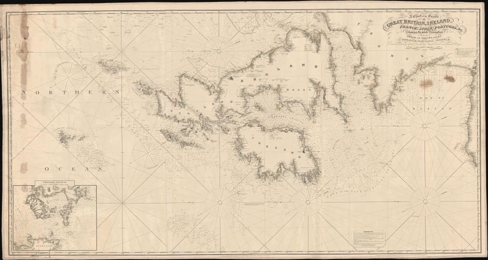
1858 Hobbs Blueback Nautical Map of the British Isles and North Sea
BritishIslesNorthSea-hobbs-1858$1,650.00


Title
A Chart of the Coasts of Great Britain, Ireland, Frace, Spain, Portugal, and c. Showing the whole Navigation from Feroe and Orkney Isles to Gibraltar, Barcelona, Algeries, etc.
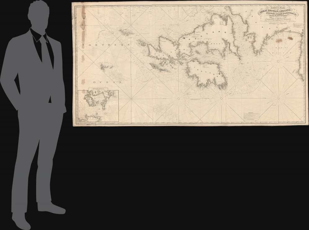
1858 (dated) 39.25 x 53.25 in (99.695 x 135.255 cm)
1858 (dated) 39.25 x 53.25 in (99.695 x 135.255 cm)
Description
This is an expansive west-oriented 1858 J. H. Hobbs nautical map of the North Sea, covering England, Ireland, Scotland, the Faroe Islands, the English Channel, and the Bay of Biscay. The chart was likely intended to service the booming British commercial fishing industry, as the coverage embraces the regions primary fisheries.
A Closer Look
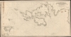
Oriented to the east and centered on the British Isles, coverage embraces a vast swath of the North Sea from north of the Faroe Islands to northern Spain. Countless depth soundings appear throughout, as well as annotations regarding shoals and other undersea dangers. Some nonspecific manuscript annotations here and there reference use at sea. There is a large inset in the lower right detailing the Pentland Firth.Inset of Pentland Frith
During the 19th century, the Pentland Firth, a strait located between the northeastern tip of mainland Scotland and the Orkney Islands, was renowned for its treacherous waters and powerful tidal currents. It presented challenges to navigation, especially for the expanding fleets of herring boats capitalizing on the 19th century British Herring Boom. The Firth was a critical passage for vessels moving between the Atlantic Ocean and the North Sea, making it strategically vital. Furthermore, its surrounding areas, influenced by the sea's bounty, saw communities grow and thrive on fishing, while tales of shipwrecks and sea lore became woven into the local cultural tapestry.Blueback Charts
Blueback nautical charts began appearing in London in the late 18th century. Bluebacks, as they came to be called, were privately published large format nautical charts known for their distinctive blue paper backing. The backing, a commonly available blue manila paper traditionally used by publishers to wrap unbound pamphlets, was adopted as a practical way to reinforce the low-quality paper used by private chart publishers in an effort to cut costs. That being said, not all blueback charts are literally backed with blue paper, some are unbacked or backed with linen. Moreover, as blueback charts which were typically composed of multiple sheets, they were designed in a modular fashion, so that multiple charts could be joined to created truely massive custom maps suited for specific voyages. The earliest known blueback charts include a 1760 chart issued by Mount and Page, and a 1787 chart issued by Robert Sayer. The tradition took off in the early 19th century, when British publishers like John Hamilton Moore, Robert Blachford, James Imray, William Heather, John William Norie, Charles Wilson, David Steel, R. H. Laurie, and John Hobbs, among others, rose to dominate the chart trade. Bluebacks became so popular that the convention was embraced by chartmakers outside of England, including Americans Edmund March Blunt and George Eldridge, as well as Scandinavian, French, German, Russian, and Spanish chartmakers. Blueback charts remained popular until the late 19th century, when government subsidized organizations like the British Admiralty Hydrographic Office and the United States Coast Survey, began issuing their own superior charts on high quality paper that did not require reinforcement.Publication History and Census
This chart was drafted and engraved by John Stratton Hobbs for the firm of Charles Wilson (operating as Norie and Wilson). It is on three sheets, joined by the publisher, all of which bear an 1851 copyright. The title of the map contained updates dating to 1858. It also suggests a possible fourth sheet may exist, extending the coverage to include Spain, Gibraltar, and North Africa, but no such sheet is known. Moreover, this is the only known example of the present map in any edition.CartographerS
John Stratton Hobbs (January 1, 1813 - December 19, 1874) was a British engraver, hydrographer, chart maker, and blueback publisher active in England in the mid-19th century. Hobbs was born in London, the son of William Henry Hobbs, a ship broker of Globe Street, St. George in the East. Much of his work is associated with the firms of John William Norie (1774 - 1843) and Charles Wilson (1807 - 1882). Hobbs compiled charts and engraved for Norie until his death in 1843, when he became head of the hydrographic department of the successor firm, Noire and Wilson. He was elected to the Royal Geographical Society 9 November 1846. More by this mapmaker...
Charles Wilson (1807 - May 16, 1882) was a British-Indian publisher of nautical charts and maps based in London, England. Born in Lucknow, India, Wilson was the son Lieutenant-Colonel William Wilson and his wife Hoosainee Begum, an Indian princess, who was the daughter of the Nizam of Ashrafabad. Wilson was educated in England and worked in the wine trade before joining the Norie firm in 1838. Norie had already partnered with another Wilson, George, who was a nephew to Charles. When Norie retired in 1840, Charles Wilson took over the firm publishing as 'Charles Wilson (Late J.W. Noire and Wilson)'. He married Jane Arabella Bingle on July 1, 1846. Wilson died in 1882 passing the firm on to his sons, George and William Wilson. The brothers merged the firm with that of J. Imray and Sons in 1899 and, as Imray, Laurie, Norie and Wilson Ltd., they continue to publish to the present day. Learn More...
John William Norie (June 3, 1772 - December 24, 1843) was a British teacher of navigation, hydrographer, chart maker, and publisher of maritime manuals active in London, England in the late 18th and early 19th centuries. Norie was born in Wapping, London, an area long associated with the maritime sciences. Norie's career as a chart maker commenced under the tutelage of William Heather, a prominent purveyor and publisher of nautical charts, pilot books, and navigational tools who took over the firm of Mount and Page in 1765. Heather and Norie were likely acquainted through John Hamilton Moore, another important chart maker with whom both seem to have been associated early in their careers. Heather hired Norie to teach basic navigation at his shop at 157 Leadenhall Street. Under Heather Norie also distinguished himself as a draftsman, completing many of the early charts associated with the Heather firm. When Heather died in 1812 John Norie partnered with George Wilson, a moneyed 'man about town' with little experience in the maritime trades, to acquire the map and chart business at 9500 British Pounds. It proved a good deal for Norie, who retained all copyright privileges and drew 1/4 quarter share of business profits, as well an impressive quarterly salary and, for doing all of the work, 1/3rd of Wilson's share. The firm, referred to as the 'Naval Warehouse' quickly acquired a reputation for quality navigational materials and became a favorite of merchant seamen. It was even referenced in Charles Dickens' classic novel Dombey and Son. In 1819, Norie and Wilson acquired the failing chart business of David Steel, which significantly increased the size, though not quality, of their chart catalogue. With the rise of the British Admiralty and its own maritime chart productions, the business of "Chart Purveyor" in London dramatically changed. Admiralty charts and pilot books, designed for military use, were offered through established intermediaries, like Norie, at bargain prices. Most chart makers of the period found it profitable to use the highly technical Admiralty charts to update their own more decorative vernacular charts. For a brief time this practice proved exceptionally profitable but eventually began to draw criticism. Nonetheless, Norie retired to Edinburgh in 1840 and died a wealthy man in 1843. In 1840 the business passed to a nephew of George Wilson, Charles Wilson, who renamed the firm "Norie & Wilson". William Heather Norie, J. W. Norie's own son, produced few charts, instead pursuing a career in the legal field. Norie & Wilson merged with James Imray's prosperous chart business in 1899, becoming Imray, Laurie, Norie & Wilson, a profitable concern that remains active in the maritime charting industry. Learn More...
Condition
Good. Some 19th century repairs on verso, including stitched sailor repair in the lower left. Some soiling and tallow stains, upper left and below title. Working nautical chart. Pencil annotations here and there.