1953 Hagstrom City Plan of Brooklyn, New York
Brooklyn-hagstrom-1953$300.00

Title
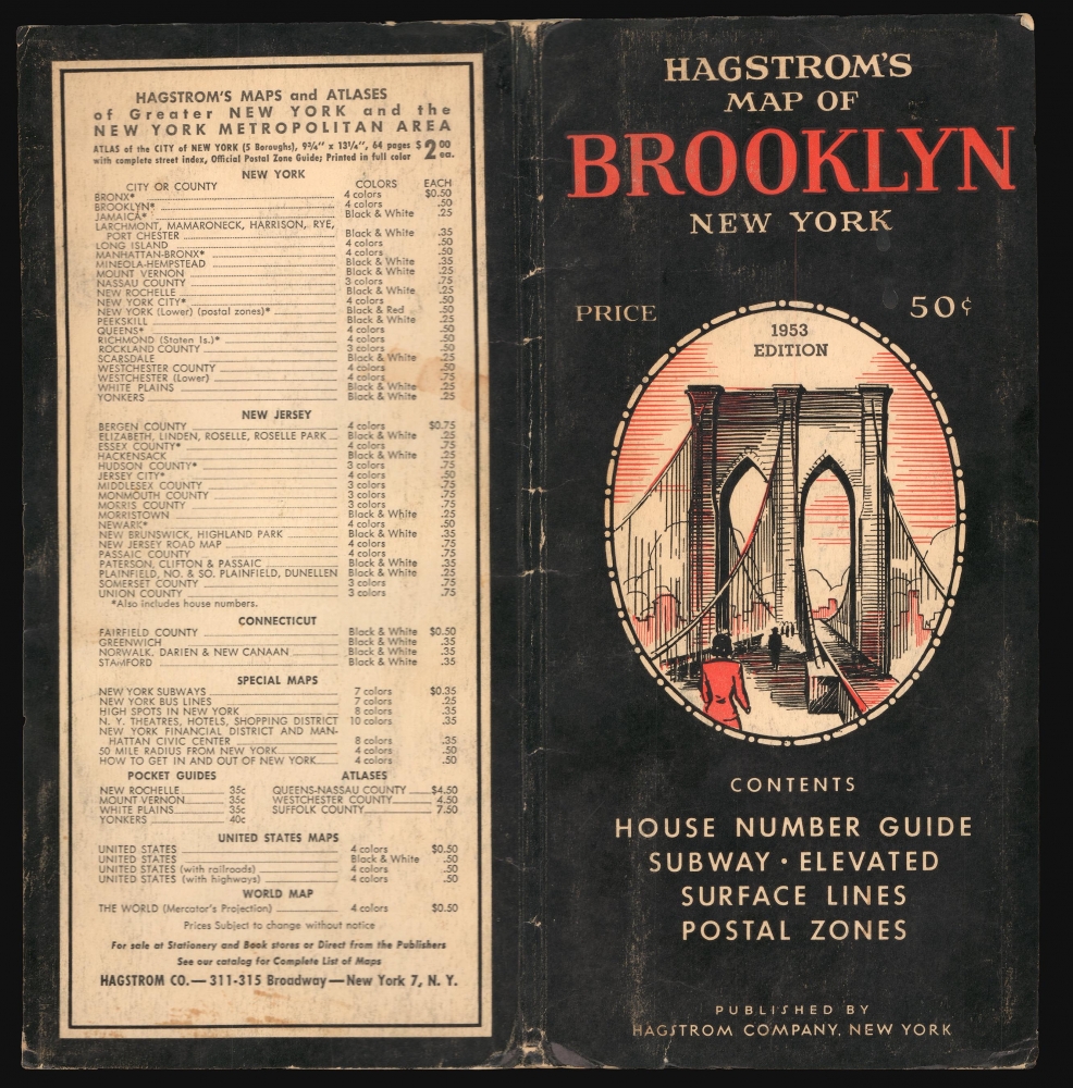
Hagstrom's Map of Brooklyn New York City House Number and Transit Guide. / Hagstrom's Map of Brooklyn New York.
1953 (dated) 29.5 x 24.75 in (74.93 x 62.865 cm) 1 : 25000
1953 (dated) 29.5 x 24.75 in (74.93 x 62.865 cm) 1 : 25000
Description
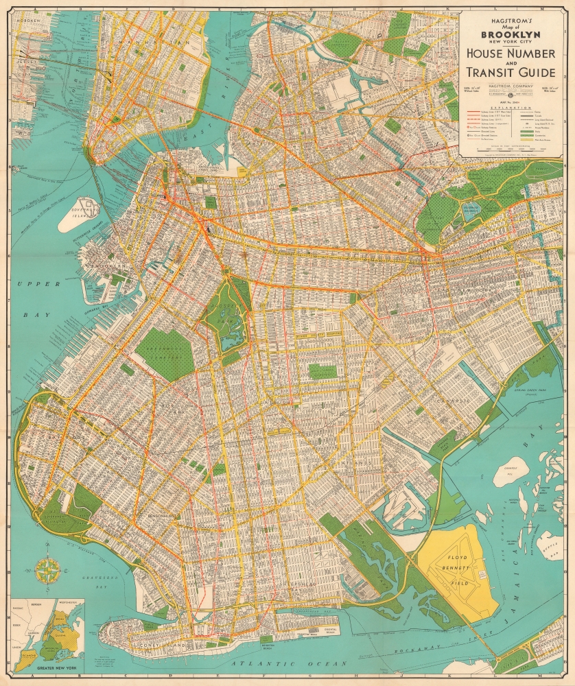
This is a 1953 Hagstrom indexed city plan or map of Brooklyn, New York City, and the immediate vicinity.
Parks are colored green, along with cemeteries, which are identified by small crosses. Prospect Park and the Botanic Gardens are depicted in some detail, with both the Central Library and the Brooklyn Museum labeled. Ebbets Field appears just east of Prospect Park; it was the home of the Brooklyn Dodgers, who, led by Jackie Robinson, were a perennial competitor for the National League pennant. An inset map at bottom-left displays Brooklyn in relation to other boroughs, Long Island, and other nearby areas.
Along the East River in Manhattan are a series of large public housing projects, including Stuyvesant Town, Peter Cooper Village, the Gov. Alfred E. Smith Houses, and the Lillian Wald Houses. Although some predated World War II (1939 - 1945), most were built during or soon after the war, some with the intention of housing hard-up veterans. Brooklyn had similar housing projects, including the Williamsburg Houses, Red Hook Houses (the largest housing development in Brooklyn), and Kingsborough Houses, all noted here.
The borough's landscape was also changing, driven by large-scale projects championed by the 'Power Broker' Robert Moses (1888 - 1981), including a complete redevelopment of Coney Island and a commitment to highways over mass transportation. The existing Brooklyn-Queens Connecting Highway was elaborated in the following years, including the highly distinctive and unusual cantilevered section covered with a pedestrian promenade in Brooklyn Heights, opened in 1954. Eventually, it would form the crux of Interstate-278, connected to New Jersey via the Verrazano Bridge, opened in 1964. Conversely, parts of the borough's economic and transportation infrastructure that had sustained it in earlier decades, such as the various subway lines, docks, warehouses, and military facilities, would begin falling into disuse and disrepair in the following years.
A Closer Look
Every street in Brooklyn is labeled, as are the streets in Manhattan up to East 25th Street and part of Queens. City blocks are numbered throughout, indicating the numerical address system used in most of New York City, especially the outer boroughs. Bridges, tunnels, ferry lines, piers, and other forms of transportation infrastructure are noted, including the Hudson Tubes now employed by the PATH trains from New Jersey. Subway lines are illustrated in red, with different symbols used to differentiate between the IRT West Side, the IRT East Side, the BMT, and the IND. Surface streetcar lines are also marked by thin red lines, while elevated subway lines are traced with solid black lines. The Long Island Railroad, running along Atlantic Ave. in Brooklyn, is also noted.Parks are colored green, along with cemeteries, which are identified by small crosses. Prospect Park and the Botanic Gardens are depicted in some detail, with both the Central Library and the Brooklyn Museum labeled. Ebbets Field appears just east of Prospect Park; it was the home of the Brooklyn Dodgers, who, led by Jackie Robinson, were a perennial competitor for the National League pennant. An inset map at bottom-left displays Brooklyn in relation to other boroughs, Long Island, and other nearby areas.
Along the East River in Manhattan are a series of large public housing projects, including Stuyvesant Town, Peter Cooper Village, the Gov. Alfred E. Smith Houses, and the Lillian Wald Houses. Although some predated World War II (1939 - 1945), most were built during or soon after the war, some with the intention of housing hard-up veterans. Brooklyn had similar housing projects, including the Williamsburg Houses, Red Hook Houses (the largest housing development in Brooklyn), and Kingsborough Houses, all noted here.
Early Postwar Brooklyn
Around the time this map was produced, Brooklyn had become completely filled in by urban development, with even neighborhoods distant from Manhattan like Sheepshead Bay and Canarsie being largely turned over to housing. On the surface, Brooklyn's population changed little as the borough had effectively maxed out the area available for housing, even considering the dense urban housing projects mentioned above. But in fact, the composition of the population changed significantly, driven by larger trends like the postwar baby boom and the Great Migration of African-Americans from the South. Then as now, the borough was defined by ethnic enclave neighborhoods, including a large Jewish population, both secular and observant, some strictly so, like the Hasidic communities of Crown Heights, Williamsburg, and Borough Park.The borough's landscape was also changing, driven by large-scale projects championed by the 'Power Broker' Robert Moses (1888 - 1981), including a complete redevelopment of Coney Island and a commitment to highways over mass transportation. The existing Brooklyn-Queens Connecting Highway was elaborated in the following years, including the highly distinctive and unusual cantilevered section covered with a pedestrian promenade in Brooklyn Heights, opened in 1954. Eventually, it would form the crux of Interstate-278, connected to New Jersey via the Verrazano Bridge, opened in 1964. Conversely, parts of the borough's economic and transportation infrastructure that had sustained it in earlier decades, such as the various subway lines, docks, warehouses, and military facilities, would begin falling into disuse and disrepair in the following years.
Publication History and Census
This map was created and published by the Hagstrom Company in 1953 (dated on the cover). The company published multiple editions of a similar map of Brooklyn between the early 1920s and the late 1970s, not all of which are dated (including a c. 1940 edition previously sold by us Brooklyn-hagstrom-1940). Among institutional collections listed in the OCLC, the Bibliothèque nationale de France holds a c. 1950 edition, while Cornell University holds a c. 1955 edition. The Brooklyn Public Library also holds a c. 1950 example as part of its Map Collection.Cartographer
Andrew Gunnar Hagstrom (1890 - September 24, 1977) was a map publisher based in Maspeth, Queens. Hagstrom was a Swedish immigrant who came to new York in 1909 where took work milking cows at a farm near Coney Island, Brooklyn. He then worked in the meat packing industry while taking a degree in commercial art at the New York Mechanics Institute. Afterwords he founded a drafting business in Manhattan, creating a map to illustrate his drafting skill help customers locate his shop. His map proved popular and he expanded operations, founding the Hagstrom Map Company (1916 - 1968) and issuing additional maps of various parts of New York City and the surrounding regions. By 1949, Hagstrom had issued more than 150 maps, guides, and atlases, most of which focused on New York. Hagstrom pioneered a cartographic style that exaggerated street size to increase clarity and create additional room for large print readable labeling. Even the New York Subway system hired Hagstrom to produce its map, which was in use from the 1940s to 1958. Hagstrom died in 1977, at the age of 81. Hagstrom was knighted by the King of Sweden. His company flourished until 1968 when it was acquired by Macmillan. The brand has since passed through multiple corporate portfolios and is currently the property by Kappa Publishing Group. More by this mapmaker...
Condition
Very good. A few minor verso stabilizations on old fold lines and were formerly attached to binder. A couple small spots of soiling.