This item has been sold, but you can get on the Waitlist to be notified if another example becomes available, or purchase a digital scan.
1864 McCloskey Historical Map of Brooklyn, New York City, in 1766
Brooklyn1766-mccloskey-1864-2$175.00

Title
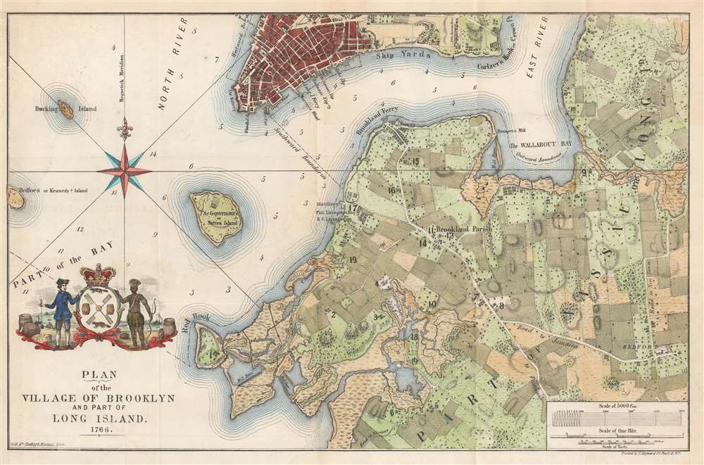
Plan of the Village of Brooklyn and part of Long Island 1766.
1864 (dated) 11 x 17 in (27.94 x 43.18 cm) 1 : 2200
1864 (dated) 11 x 17 in (27.94 x 43.18 cm) 1 : 2200
Description
This is an unusual and appealing 1864 map of Brooklyn, New York, as it appeared in 1766, towards the end of the colonial period. The map depicts parts of modern-day Brooklyn from Red Hook to Bedford and from Williamsburg to Flatbush. The region is divided into land parcels which represent early land holdings. Various buildings are noted, some numerically, but the map offers no key to more specifically identifying them.
The Ratzer or Ratzen Plan of New York City
Cartographically, this map is a reduction of the lower portion of the famous 1766 Ratzer (or Ratzen) plan of New York City. The Ratzer Plan is one of the most important, beautiful, and iconic colonial era maps of New York City. It was surveyed by Bernard Ratzer in 1767. Augustyn and Cohen in Manhattan in Maps comment thatThe Ratzer Plan evokes a halcyon period in the history of Manhattan, at least in regard to its physical reality. The city at the time was a small but vibrant place with a population of about twenty-five thousand, for whom the countryside was a short carriage ride away. Also readily at hand were the recreational delights as well as economic advantages of the sea.
Publication History and Census
This map was drawn by A. Brown of 47 Nassau Street, New York, for inclusion in Henry McCloskey's 1864 Manual of the City and Corporation of Brooklyn. An example of this map is cataloged in OCLC and is part of the institutional collection at Princeton University. An example is also part of the collections at the University of Wisconsin Milwaukee and the Brooklyn Historical Society.Cartographer
Henry McCloskey (fl. c. 1863 - 1867) was a journalist working in Brooklyn in the mid 19th century. He was the first regular reporter employed by the Brooklyn Daily Eagle and consequently the first true Brooklyn reporter. When the editor Arnold resigned, McCloskey stepped up to the position became Editor-in-chief. An ardent southern sympathizer and fierce advocate of states' rights, McCloskey had no shame in using the Eagle to express his radical political views. In 1861, following the outbreak of the Civil War, McCloskey published a series of aggressive anti-war editorials. Shortly thereafter, the Eagle, along with several other news papers including the New York News, were accused of disloyalty to the Union and denied access to the U.S. Mail system. The charges were dropped when McCloskey resigned shortly afterwards. McCloskey's true interest was government and in 1863 he was voted city clerk for Brooklyn. He retained this position from 1863 to 1867. Both his predecessor and successor seem to have been William Bishop. One of the duties of the city clerk was to publish an annual report detailing the government, progress, urban planning and development of the city. The resulting Manual bearing the McCloskey name was published during his four years of tenure as City Clerk. The first Brooklyn Manual was published in 1855 following the consolidation of the city. The Manual was published under various names and in various forms until 1888. More by this mapmaker...
Source
McCloskey, H., Manual of the City and Corporation of Brooklyn, 1864, (Brooklyn) 1864.
Condition
Very good. Exhibits light wear along original fold lines. Verso repairs to fold separations. Closed one-half (.5) inch margin tear professionally repaired on verso.
References
Haskell, D., Manhattan Maps A Co-operative List, 319-346 (the Ratzer Plan). University of Milwaukee Rare 862.5 B-1766 1864. OCLC 58758662.