This item has been sold, but you can get on the Waitlist to be notified if another example becomes available, or purchase a digital scan.
1917 Rand McNally Map of Brooklyn, New York
Brooklyn2-randmcnally-1917$225.00

Title
Rand McNally Map of Brooklyn.
1917 (dated) 31 x 29.5 in (78.74 x 74.93 cm) 1: 24000
1917 (dated) 31 x 29.5 in (78.74 x 74.93 cm) 1: 24000
Description
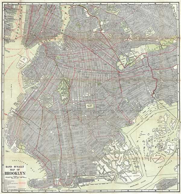
This impressive map is a large format edition of Rand McNally's 1917 map of Brooklyn, New York. Unlike most earlier maps of Brooklyn, this map covers Brooklyn much as it appears today, extending from New York Harbor to Woodhaven (Queens) and from the Newtown Creek to Coney Island. Communities like Bay Ridge, Bensonhurst, Sheepshead Bay, Canarsie, and East New York, which did not officially become part of Brooklyn until the turn of the century, are fully incorporated into this map. The map identifies all streets and parks, as well as shipping lanes, and important buildings, such as Fort Jay on Governors Island. This map was printed in 1917 by Rand McNally and Company from their New York office.
Cartographer
Rand, McNally and Co. (fl. 1856 - present) is an American publisher of maps, atlases and globes. The company was founded in 1856 when William H. Rand, a native of Quincy, Massachusetts, opened a print shop in Chicago. Rand hired the recent Irish immigrant Andrew McNally to assist in the shop giving him a wage of 9 USD per week. The duo landed several important contracts, including the Tribune's (later renamed the Chicago Tribune) printing operation. In 1872, Rand McNally produced its first map, a railroad guide, using a new cost effective printing technique known as wax process engraving. As Chicago developed as a railway hub, the Rand firm, now incorporated as Rand McNally, began producing a wide array of railroad maps and guides. Over time, the firm expanded into atlases, globes, educational material, and general literature. By embracing the wax engraving process, Rand McNally was able to dominate the map and atlas market, pushing more traditional American lithographic publishers like Colton, Johnson, and Mitchell out of business. Eventually Rand McNally opened an annex office in New York City headed by Caleb S. Hammond, whose name is today synonymous with maps and atlases, and who later started his own map company, C. S. Hammond & Co. Both firms remain in business. More by this mapmaker...
Condition
Very good. Professionally flattened and backed on archival tissue. Some light wear on original folds, especially at fold intersections. Blank on verso.