This item has been sold, but you can get on the Waitlist to be notified if another example becomes available.
1969 Richard Rosenblum Pictorial View of Brooklyn, New York
BrooklynPictorial-rosenblum-1969$250.00

Title
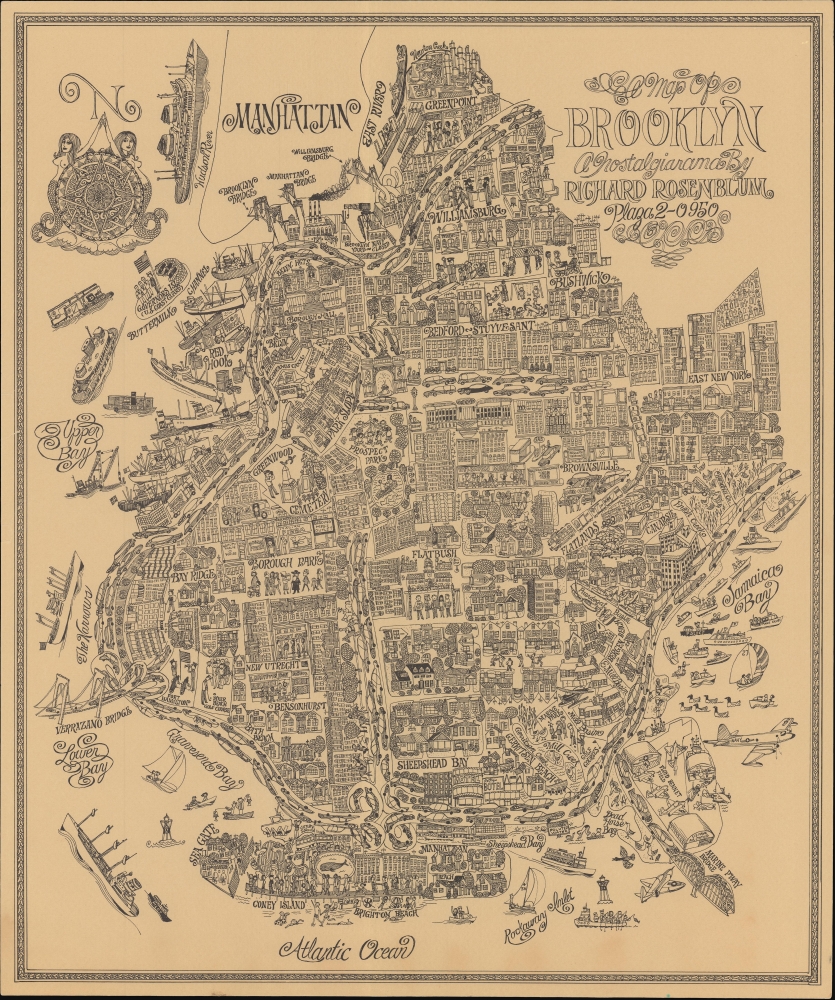
A Map of Brooklyn a Nostalgiarama.
1969 (undated) 18.5 x 15.5 in (46.99 x 39.37 cm)
1969 (undated) 18.5 x 15.5 in (46.99 x 39.37 cm)
Description
A rare, whimsical c. 1969 pictorial view of Brooklyn, New York, drawn by children's book illustrator Richard Rosenblum. It paints a rosy picture, a 'nostalgiarama' as the subtitle puts it, of Brooklyn and New York City at a time generally considered a nadir.
A Closer Look
Covering the borough of Brooklyn, Rosenblum provides a visually rich portrait of his hometown that warrants long and careful examination. Neighborhoods, bridges, parks, cemeteries, playgrounds, churches, synagogues, factories, shops, restaurants, and other features are illustrated throughout. Houses and apartment buildings dominate the neighborhoods, along with people representing diverse populations. Automobiles flow along interstates and parkways, while the Long Island Railroad, the subway, trucks, and ships and boats of various types also make an appearance. Governor's Island and the coastline of Manhattan appear at top-left, along with an elaborate compass rose complete with mermaids.Historical Context
Despite the deep troubles facing New York City at the time (see below), Rosenblum presents Brooklyn as a thriving, diverse borough full of charming, friendly neighborhoods, though, as the subtitle indicates, this may reflect an idealized past rather than the contemporary situation. For instance, Brighton Beach and Coney Island in the foreground are presented as flourishing, family-friendly beachfront neighborhoods. In reality, both neighborhoods, and Coney Island in particular, were targeted for 'redevelopment' by government officials and developers (including Robert Moses and Fred Trump), as they had fallen from their earlier heights as the preferred site for waterfront recreation. Both neighborhoods saw increased crime, decreased population, and destruction of many buildings.Historical Context
The 1960s are generally considered to have been the beginning of a downturn for New York City that lasted several decades. Deindustrialization and other economic troubles led to poverty, drug use, and crime. The city saw a population decrease for the first time in history as those with means fled to the suburbs. Pollution was rampant, and society was restive, with protests, riots, racial tensions, and strikes common, including a 1968 strike by sanitation workers. Brooklyn was particularly hurt by the closure of the U.S. Navy Yard in 1966 and the completion of the Verrazzano Narrows Bridge, which diminished the need for waterfront industries and warehouses, especially along the Gowanus Canal. Although the subtitle is somewhat cryptic, Rosenblum's view is an important reminder that not all New Yorkers regarded their city with scorn in these years, even if they longed for better times.Publication History and Census
This pictorial view was drawn by Richard Rosenblum around the year 1969. The only other known example is held by the Brooklyn Library, which provides the suggested date.Cartographer
Richard Irwin Rosenblum (1928 - 2002) was an artist, illustrator, children's book author, and educator based in Brooklyn, New York. Little is known about his early life and training, but he appears to have been a lifelong Brooklynite and is known to have attended Cooper Union. He is best known for illustrating several children's books dealing with Brooklyn and Jewish life in New York City, including Brooklyn Dodger Days (1991) and The Old Synagogue. He also illustrated children's books related to transportation, such as Wings, the Early Years of Aviation and Tugboats. Rosenblum worked as an illustrator for the New York Herald Tribune, at least ocasssionally, and also briefly in the television and film industry. He also taught courses at the New School for Social Research. More by this mapmaker...
Condition
Very good. Small border tears professionally repaired.
References
Brooklyn Library Call No. MAP_1969-01-01.