This item has been sold, but you can get on the Waitlist to be notified if another example becomes available, or purchase a digital scan.
1892 Rand McNally Map of Buffalo, New York
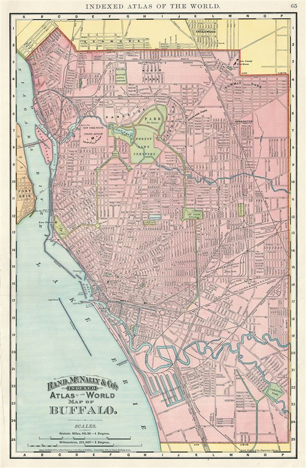
Buffalo-randmcnally-1893$45.00

Title
Buffalo.
1892 (dated) 20 x 13 in (50.8 x 33.02 cm) 1 : 32500
1892 (dated) 20 x 13 in (50.8 x 33.02 cm) 1 : 32500
Description
This is a nice example of the 1892 Rand McNally and Company map or Plan of the City of Buffalo, New York. It covers eastward from Lake Erie and the Niagara River and covers the entire city of Buffalo, including part of Fort Erie, Kenmore and Englewood. The map is highly detailed and notes rivers, parks, docks, cemeteries, reservoirs, railways, and other topographical details. Individual streets and buildings are identified, including the New York state insane asylum, court house, city hall, etc. Joseph Elicott, city planner and surveyor for the Holland Land Company, designed and laid the grid system seen in this map. This map was issued as plate no. 65 in the 1893 edition of Rand McNally and Company's Indexed Atlas of the World- possibly the finest atlas Rand McNally ever issued.
Cartographer
Rand, McNally and Co. (fl. 1856 - present) is an American publisher of maps, atlases and globes. The company was founded in 1856 when William H. Rand, a native of Quincy, Massachusetts, opened a print shop in Chicago. Rand hired the recent Irish immigrant Andrew McNally to assist in the shop giving him a wage of 9 USD per week. The duo landed several important contracts, including the Tribune's (later renamed the Chicago Tribune) printing operation. In 1872, Rand McNally produced its first map, a railroad guide, using a new cost effective printing technique known as wax process engraving. As Chicago developed as a railway hub, the Rand firm, now incorporated as Rand McNally, began producing a wide array of railroad maps and guides. Over time, the firm expanded into atlases, globes, educational material, and general literature. By embracing the wax engraving process, Rand McNally was able to dominate the map and atlas market, pushing more traditional American lithographic publishers like Colton, Johnson, and Mitchell out of business. Eventually Rand McNally opened an annex office in New York City headed by Caleb S. Hammond, whose name is today synonymous with maps and atlases, and who later started his own map company, C. S. Hammond & Co. Both firms remain in business. More by this mapmaker...
Source
Rand McNally & Co., Rand, McNally & Co's Indexed Atlas of the World, (Chicago) 1893.
Condition
Very good. Text on verso. Minor verso repair in left margin, not extending onto printed area.
References
Rumsey 3565.075 (1897 edition). Philips (atlases) 1026 (1898 edition).