This item has been sold, but you can get on the Waitlist to be notified if another example becomes available, or purchase a digital scan.
1818 Berniere and Harrison Map of the Battle of Bunker Hill
BunkerHill-berniereharrison-1818$1,125.00

Title
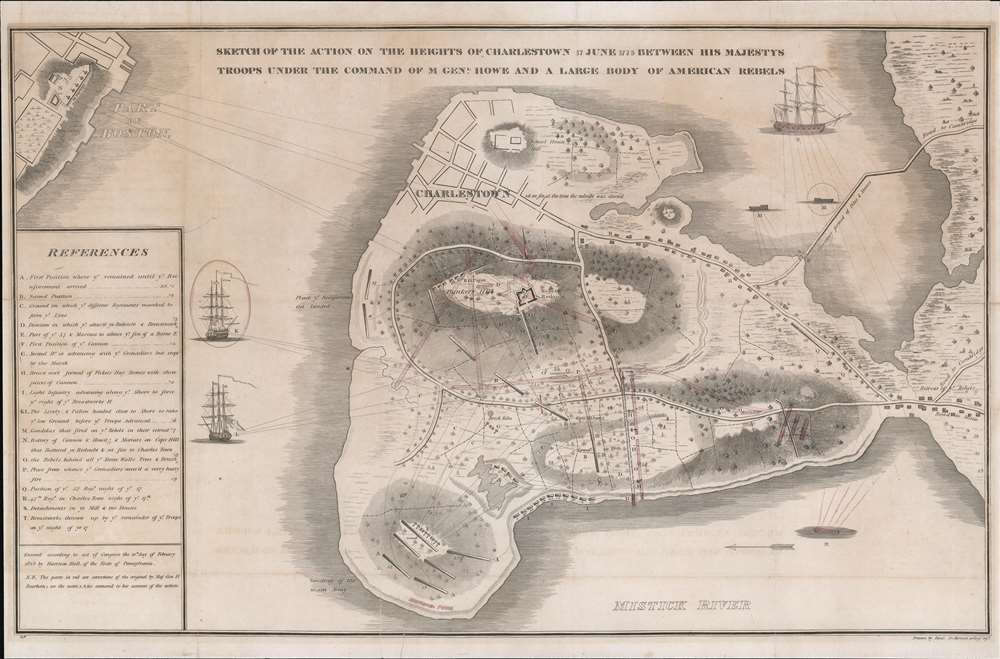
Sketch of the Action on the Heights of Charlestown 17 June 1775 Between His Majesty's Troops Under the Command of M. Genl. Howe and a Large Body of American Rebels.
1818 (dated) 13.25 x 20.25 in (33.655 x 51.435 cm) 1 : 5400
1818 (dated) 13.25 x 20.25 in (33.655 x 51.435 cm) 1 : 5400
Description
This is a rare 1818 map of the 1775 American Revolutionary War Battle of Bunker's Hill, Boston. Cartographically, the map is derived from a sketch by Henry De Berniere, a reconnaissance Ensign (spy) under British commanding General Thomas Gage. The original manuscript, from all reports, was discovered in a trunk in the early 19th century. De Berniere witnessed Bunkers Hill first-hand and prepared the map for his report to Gage. The map is distinctive for its exacting attention to detail and topography, including the layout of Charlestown, as well as its overall fine execution, illustrating all troop movements, underscoring's De Berniere's officer's education as a military engineer and draftsman. When the map was discovered in an old trunk, it was instantly recognized as the finest record of the battle available and became the model for most subsequent illustrations of the events.
Battle of Bunker Hill
Fought on June 17, 1775, the Battle of Bunker Hill was one of the first battles of the American Revolutionary War (1775 - 1783). When colonial troops discovered British plans to occupy the hills surrounding Boston, thus securing control of the Harbor, they preemptively established themselves on Bunkers Hill and Breeds Hill. Confident in their superiority, the British led two unsuccessful charges against the fortified position. Although the British finally succeeded in gaining control of the both hills and the peninsula, the victory came at a high price. British casualties were 1054 (226 killed), many of whom were officers, compared to Colonial casualties of just 450 (140 killed). The battle made clear that the war would be no easy victory for the British, while at the same time, bolstering the confidence of the comparatively inexperienced Colonial forces.The Port Folio
This map was produced for Port Folio magazine. First published in January 1801, the Port Folio was a Philadelphia-based American octavo magazine 'devoted to Useful Science, the Liberal Arts, Legitimate Criticism, and Polite Literature.' It was published as a weekly from 1801 through 1809, when it transitioned to a monthly. The magazine was acquired by Harrison Hall (1875 - 1866) in 1815. It was heavily illustrated with historical, scientific, and scenic imagery. After a 27-year run, The Port Folio finally folded in 1827.Publication History and Census
This map was drawn by Henry De Berniere in 1775. It was lost for the subsequent 40 years until rediscovered and engraved by Harrison Hall and published in February 10, 1818 in Philadelphia for the March 1818 Port Folio (Philadelphia 1801 - 1827). De Berniere's original manuscript survives, with manuscript annotations by Maj. General Dearborn, in the collections of the American Philosophical Society. The 1818 edition here should not be confused with a smaller and more simplistic version of the map engraved later in the same year by 'Kneass, Young, and Company' for publication in The Analectic Magazine. There was later 1824 issued of the smaller 'Kneass, Young, and Company' edition by John Melish. The present 1818 Harrison Hall example is the first edition and quite rare on the market. We have identified only a single previous sale record and just 7 holdings institutional collections: The Morgan Library, the New York Public Library, Yale, the Boston Athenaeum, the Library of Congress, the University of Milwaukee, and the Clements Library. A rare opportunity for the Boston or Revolutionary War collector.Cartographer
Server Error
404
Page Not Found
This page either doesn't exist, or it moved somewhere else.
That's what you can do
Source
The Port Folio, (Philadelphia: Hall) March 1818.
Condition
Very good. Remnants of old fold lines. Some toning and offsetting. Minor tear bottom center. Laid down on archival tissue.
References
OCLC 166645688. Morgan Library and Museum, PML 3742. New York Public Library, Map Div. 16-805. University of Milwaukee, 842-d .B67 B-1775 1818. Phillips (America) page 181.