This item has been sold, but you can get on the Waitlist to be notified if another example becomes available, or purchase a digital scan.
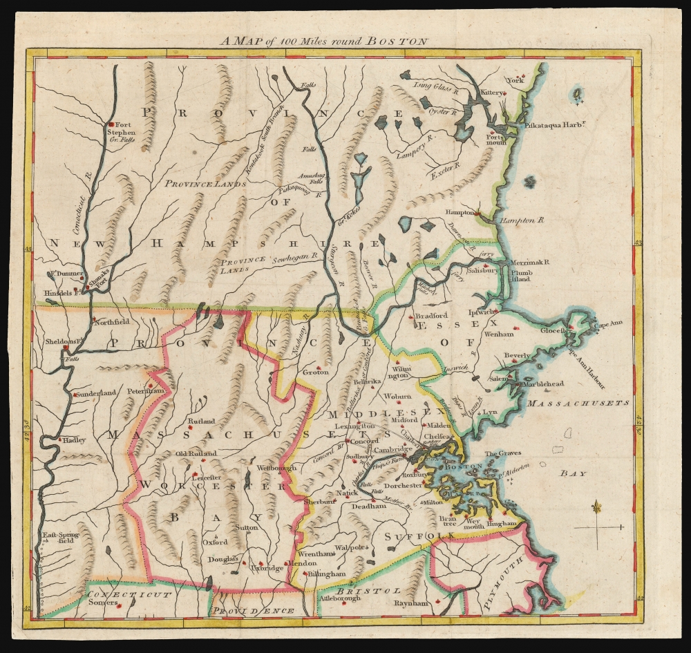
1775 Gentleman's Magazine Map of the Boston Region: First Map to note Bunker Hill
BunkerHill-gentsmag-1775$275.00

Title
A Map of 100 Miles round Boston.
1775 (undated) 9.25 x 9.75 in (23.495 x 24.765 cm) 1 : 795000
1775 (undated) 9.25 x 9.75 in (23.495 x 24.765 cm) 1 : 795000
Description
This 1775 map of the region surrounding Boston, issued in the early days of the American Revolutionary War, is the earliest printed map to name Bunkers Hill, and was printed before the results of the battle were known. This map appeared astonishingly early, in the June 1775 issue of The Gentleman's Magazine. The issue's contents page includes the following note with respect to this map:
Even so, this means the appearance of 'Bunkers Hill' on the present work is astonishingly early. American forces began to occupy Bunker Hill on June 13. Their fortifications were noted by the British on the 16th and the battle took place on the 17th. If the statement on the contents page of the June issue is correct - 'within Sight of each other, and are hourly expected to engage.' - then to beat a deadline of the first week in July a mail packet would have to have crossed the Atlantic from Boston in an amazing three weeks, half what larger ships could expect, and as fast as a mail packet could ever hope for.
The map overall was probably already complete ahead of time. The June issue of the magazine already included reports and discussion of the battles of Lexington and Concord, and the map - with its notation of Phipps' Farm - was clearly aimed at supporting them. Updating it to allude to the battle of Bunker Hill required the addition of only two words. Nevertheless their appearance here - for a battle whose outcome was simultaneously unknown and yet a fait accompli is a remarkable and unique instance on a map.
It is possible that a version of the map lacking the Bunkers Hill notation might have appeared in the June issue, to be replaced by an amended version in the annual publication of the Magazine. However, we have neither seen an example of this map without the Bunkers Hill note, nor even seen reference to one. We are left to conclude that the present example is the only state of the work, and was printed in July of 1775 to be included in the June 1775 monthly edition of the Magazine.
with an accurate Map of the Country One Hundred Miles round Boston, in order to shew the Situation and March of the Troops, as well Provincials as Regulars, which are now within Sight of each other, and are hourly expected to engage.(emphasis ours)So although the map appeared in print just following the battle, it was printed before the outcome, or even the first shot, of the battle was actually reported in England.
A Closer Look
The region covered extends from Massachusetts Bay to the Connecticut River in the west; it spans from northern Connecticut up into New Hampshire and part of what is now Maine, including Kittery and York. Overall, its geography is drawn from Jefferys' A Map of the Most Inhabited Part of New England, which was the best detailed map of the region heading into the Revolution. The map includes not only Concord and Lexington, but also Phipps' Farm - shown in italics - which was the point at which the British regulars landed in April of 1775 en route to those towns. Phipps' Farm, of course, made no appearance on the Jefferys. Also in italics, more surprisingly, is Bunkers Hill. The scale of the map does not permit the hill to be precisely located with Charles Town, but is as close as can be in the context of this work. No earlier plan of Boston and its vicinity of which we are aware includes this place name.Context and Timing
Each issue of The Gentleman's Magazine was a retrospective work, chronicling the events of that month along with relevant events of prior months. Consequently, they were published after, not during, the month to which they were dedicated; generally, the first week of the following month or thereabouts. Thus, it would be expected that the June issue would appear in July.Even so, this means the appearance of 'Bunkers Hill' on the present work is astonishingly early. American forces began to occupy Bunker Hill on June 13. Their fortifications were noted by the British on the 16th and the battle took place on the 17th. If the statement on the contents page of the June issue is correct - 'within Sight of each other, and are hourly expected to engage.' - then to beat a deadline of the first week in July a mail packet would have to have crossed the Atlantic from Boston in an amazing three weeks, half what larger ships could expect, and as fast as a mail packet could ever hope for.
The map overall was probably already complete ahead of time. The June issue of the magazine already included reports and discussion of the battles of Lexington and Concord, and the map - with its notation of Phipps' Farm - was clearly aimed at supporting them. Updating it to allude to the battle of Bunker Hill required the addition of only two words. Nevertheless their appearance here - for a battle whose outcome was simultaneously unknown and yet a fait accompli is a remarkable and unique instance on a map.
It is possible that a version of the map lacking the Bunkers Hill notation might have appeared in the June issue, to be replaced by an amended version in the annual publication of the Magazine. However, we have neither seen an example of this map without the Bunkers Hill note, nor even seen reference to one. We are left to conclude that the present example is the only state of the work, and was printed in July of 1775 to be included in the June 1775 monthly edition of the Magazine.
Publication History and Census
This map appeared in the June issue of the 1775 (volume 45) of The Gentleman's Magazine. It should not be mistaken for the Dublin-published, reduced format map of the same title noted in McCorkle. We see only five separate examples in institutional collections, but the map does appear on the market with some regularity and despite its significance is an affordable piece of American Revolutionary history.Cartographer
The Gentleman's Magazine (fl. c. 1731 - 1922) was an English periodical founded by visionary Edward Cave. Considered the world's first monthly general interest magazine, GM was also known as Trader's Monthly Intelligencer. Cave's innovation was to create a monthly digest of news and commentary on any topic the educated public might be interested in, from commodity prices to Latin poetry. It carried original content from a stable of regular contributors, as well as extensive quotes and extracts from other periodicals and books. Cave, who edited The Gentleman's Magazine under the pen name "Sylvanus Urban", was the first to use the term "magazine" (meaning "storehouse") for a periodical. The iconic illustration of St John's Gate on the front of each issue (occasionally updated over the years) depicted Cave's home, in effect, the magazine's "office". Among the important firsts of the The Gentleman's Magazine are the first use of the term "magazine" for a periodical and the first regular employment of lexicographer Samuel Johnson. More by this mapmaker...
Source
The Gentleman's Magazine, (London) v. 45, June 1775.
Condition
Very good. Margins close but complete.
References
Jolly, D. C., Maps in British Periodicals, GENT-234. Sellers, John R. and Van Ee, Patricia, Maps and Charts of North America, no. 891. Boston Public Library, Leventhal, G3720 1775 .M3.