This item has been sold, but you can get on the Waitlist to be notified if another example becomes available, or purchase a digital scan.
1584 Ortelius Map of Burgundy, France (Wine Regions)
Burgundiae-ortelius-1584$325.00

Title
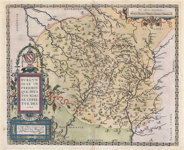
Burgundiae Inferioris Quae Ducatus Nomine Censetur, Des.
1584 (dated) 15 x 18 in (38.1 x 45.72 cm) 1 : 200000
1584 (dated) 15 x 18 in (38.1 x 45.72 cm) 1 : 200000
Description
A stunning first edition first state example of the 1584 first edition of Ortelius' classic map of Burgundy, France. Although Ortelius references this region as 'Burgindiae Inferioris' or Lower Burgundy, it specifically covers those areas which are today most commonly associated with the production of Burgundy Wine - arguably the finest French wine. The Burgundy wine regions included on this map include four of the five primary divisions: Chablis, Cote de Nuits, Cote de Beaune, and Cote Chalonnaise. Maconnais, the fifth, is just a little further to the south along the Saone River. It also includes the cities of Avalon, Auttun, Chalons, Beaulne, Verdun, and Chastillon, among many others.
Ortelius printed approximately 100 copies of this map before making minor changes for a second printing. Over the course of this map's entire run, approximately 5050 were printed in for various versions of the Theatrum, though only one state exists. It is impossible to know how many have survived the subsequent centuries.
Ortelius printed approximately 100 copies of this map before making minor changes for a second printing. Over the course of this map's entire run, approximately 5050 were printed in for various versions of the Theatrum, though only one state exists. It is impossible to know how many have survived the subsequent centuries.
Cartographer
Abraham Ortelius (April 14, 1527 - June 28, 1598) also known as Ortels, was a cartographer, geographer, and cosmographer of Brabant, active in Antwerp. He was the creator of the first modern atlas, Theatrum Orbis Terrarum and is a seminal figure in the history of cartography. Along with Gerard Mercator and Gemma Frisius, he was a founder of the Netherlandish school of cartography. His connections with Spain - culminating in his 1575 appointment as Royal Cartographer to King Phillip II of Spain - gave him unmatched access to Spanish geographical knowledge during a crucial period of the Age of Discovery. Ortelius was born in 1527 in Antwerp. In 1547 he entered the Antwerp Guild of Saint Luke as an illuminator of maps. He began trading in books, prints, and maps, traveling regularly to the Frankfurt book and print fair, where in 1554 he met Mercator. He accompanied Mercator on journeys throughout France in 1560 and it was at this time, under Mercator's influence, that he appears to have chosen his career as a scientific geographer. His first published geographic work appeared in 1564, an eight-sheet cordiform world map. A handful of other maps preceded the 1570 publication of the first edition of the Theatrum Orbis Terrarum, which would prove to be his life work. Appearing with but 53 maps in its first edition, Ortelius' work expanded with new maps added regularly. By 1592, it had 134 maps. Many of Ortelius' maps remained the standard for nearly a century. He traveled extensively, but his genius was as a compiler, locating the best informed maps on which to base his own. His contacts throughout Europe and extending even (via the Portuguese) to the Far East were formidable. Moreover, many of his maps were based on his own scholarship, particularly his historical works. His theories of geography were particularly ahead of his time with respect to the notion of continental drift, the possibility of which he mused on as early as 1596, and which would be proven correct centuries later.
In a sense his greatest achievement was his successful navigation of the religious and political violence endemic to his city throughout his adult life: The Dutch Revolt, or Eighty Years' War (1568 - 1648), fully embroiled Antwerp. Although outwardly and officially recognized as Catholic (Arias Montanus vouched for Ortelius' Catholic orthodoxy prior to his appointment as Royal Geographer), Ortelius was able to separate himself from the religious furor which characterized the war in the low countries. Ortelius showed a glimpse of himself in a letter to a friend, regarding humanist Justus Lipsius: 'I do not know whether he is an adherent of the Pope or a Calvinist, but if he has ears to hear, he will neither be one nor the other, for sins are committed on both sides'. Ortelius' own explorations of Biblical history in his maps, and the Christogram contained in his own motto, suggest him to be a religious man, but his abjuration of political religious authorities mark him as an individualist. His tombstone at St Michael's Præmonstratensian Abbey in Antwerp bears the inscription, Quietis cultor sine lite, uxore, prole. ('served quietly, without accusation, wife, and offspring.') More by this mapmaker...
Source
Ortelius, A., Theatrum Orbis Terrarum, (Amsterdam) 1584.
Condition
Very good. Original pressmark visible. Latin text on verso. Old tape on verso, at margins, due to previous framing. Minor repaired centerfold split limited to lower margin.
References
Van den Broecke, Ort 54 (Koeman/Meurer: 96, Karrow: 1/142, van der Krogt AN: 4870:31A).