
This item below is out of stock, but another example (left) is available. To view the available item, click "Details."
Details
1882 Eldridge Nautical Chart or Map of Buzzard Bay, Massachusetts
1882 (dated) $1,950.00
1877 Eldridge Nautical Chart or Map of Buzzard Bay, Massachusetts
BuzzardsBay-eldridge-1877$650.00


Title
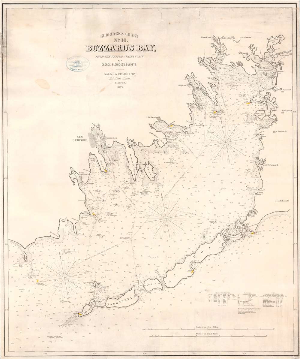
Eldridge's Chart No. 10. Buzzard's Bay, from the United States Coast and George Eldridge's Surveys.
1877 (dated) 30.5 x 36.5 in (77.47 x 92.71 cm) 1 : 55000
1877 (dated) 30.5 x 36.5 in (77.47 x 92.71 cm) 1 : 55000
Description
This is a scarce separately issued 1877 George Eldridge nautical chart or maritime map of Buzzard's Bay, Massachusetts. This elegantly produced chart on thick stock depicts from the west coast of Cape Cod and includes New Bedford, Falmouth, Sippican, Wareham, Woods Hole, and Mattapoisett, among other towns. Eldridge provides excellent maritime detail throughout with numerous soundings (in feet) and notations for undersea ledges, shoals, and other dangers. Cartographically this chart is based on the work of the U.S. Coast Survey (U.S.C.S.) as well as Eldridge's own private surveys.
Michael Rupp - The Original Seller
A stamp on the front of the chart identifies the original seller, Michael Rupp and Company. Rupp was a New York City based manufacturer of chronometers (nautical clocks) and chartseller. His offices were at 39 South Street in what is today the South Street Seaport historic district. The verso bears two stamps, one identifying the chart and a second offering a catalog of Eldridge charts numbering 1 through 13, this being no 10.Publication History and Census
Eldridge originally published this chart in 1874 in partnership with Samuel Thaxter Cushing. It proved popular through numerous editions until about 1895. The present example, 1877, is therefore an unusually early edition. Three examples of this map are cataloged in OCLC and represent editions published in 1885 and 1896. An example dating from 1876 is part of the collection at the Leventhal Map Center at the Boston Public Library.CartographerS
George Eldridge (November 27, 1821 - August 23, 1900) and his son George Washington Eldridge (1845 - 1914) were American makers of nautical charts and Pilot Books active in the late 19th century. George Eldridge was a Cape Cod fisherman known locally as an excellent ship's pilot. While recuperating from an injury in 1851, Eldridge drew his first nautical chart. The chart proved popular, and its success led Eldridge to pursue a career in hydrography - the science of mapping the sea with a special focus on navigation. Eldridge produced numerous subsequent maps and is credited with issuing some of the earliest accurate nautical charts of the American Atlantic coast. In time George Eldridge passed his thriving business on to his son, George Washington Eldridge, who continued to produce beautiful and practical maritime charts until 1924.Though most of Eldridge's charts were loosely based on U.S. Coast Survey work, they proved popular with navigators. The Eldridges possessed a talent, shared by both father and son, for distilling the often convoluted Coast Survey maps into practical nautical charts for the working mariner. From 1875, in addition to large format independently issued nautical charts, Eldridge also issued annual editions of Eldridge's Tide and Pilot Book and The Book of Harbor Charts. The Eldridge offices were located at 103 State St. Boston, Massachusetts. After the deaths of George and George Washington Eldridge, the firm passed into the hands of the latter's widow Sydna, and son-in-law, Wilfrid O. Wight. Wight's son and subsequent generations have continued to publish the Eldridge Tide and Pilot Book down to the present. More by this mapmaker...
Samuel Thaxter and Son (fl. 1792 - 1916). Samuel Thaxter (1769 - 1842) is the founder of a Boston dynasty of manufacturers of mathematical instruments and nautical charts. He founded the firm in 1792 and is first referenced in the 1796 Boston Directory. Around 1822 he incorporated his son, Joseph H. Thaxter (1801 - 1835), into the business renaming it 'Samuel Thaxter and Son'. The firm would retain this name for the remainder of its existence. This successful business was subsequently passed to Joseph H. Thaxter's son, Samuel Thaxter Cushing (1821 - 1882), in 1843. It was Thaxter Cushing who developed the firm's publishing arm, partnering with the Boston nautical chart maker George Eldridge. They are best known for 13 large format blueback charts focusing on the east cost of the United States published in the second half of the 19th century. They also published numerous smaller maps and pilot books. After Thaxter Cushing died the firm was taken over by his widow, Abby C. Cushing, who managed it until 1905. It was subsequently managed by Herbert Risteen Starratt and continued to be registered in the Boston Directory until about 1916. Learn More...
Condition
Very good condition. Professionally flattened and backed with fresh linen. Upper border repaired. Minor soiling.
References
Boston Public Library, Leventhal Collection, G3762.B8P5 1876. OCLC: 57014527 (1885).