1935 Survey of Egypt City Plan of Cairo, Egypt
Cairo-surveyofegypt-1935$450.00


Title
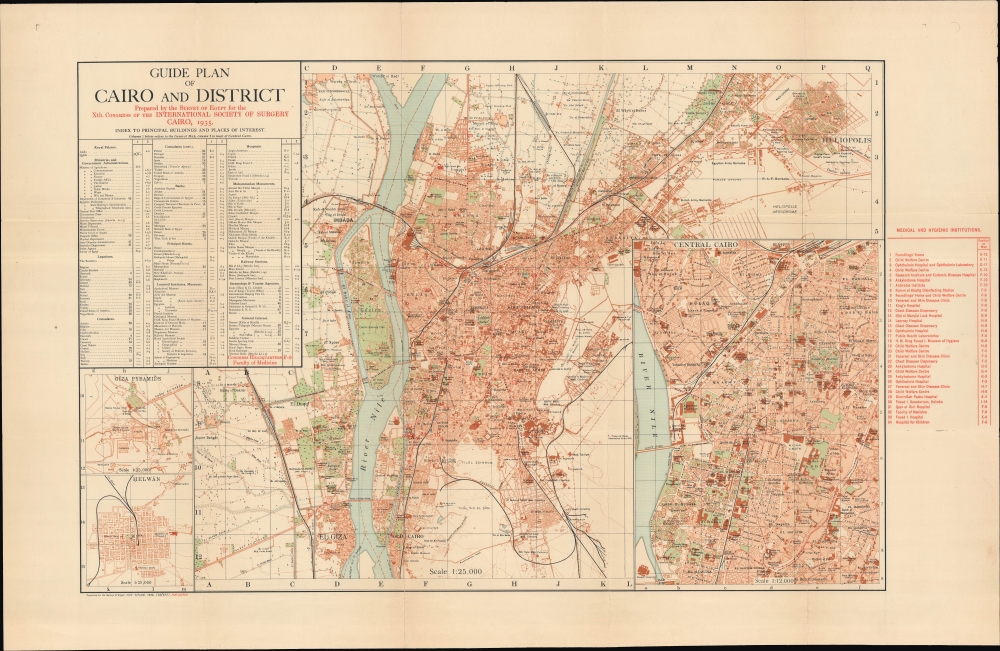
Guide Plan of Cairo and District Prepared by the Survey of Egypt for the Xth. Congress of the International Society of Surgery.
1935 (dated) 19 x 32.25 in (48.26 x 81.915 cm) 1 : 25000
1935 (dated) 19 x 32.25 in (48.26 x 81.915 cm) 1 : 25000
Description
A scarce 1935 Survey of Egypt city map of Cairo under the British Protectorate, here produced for an international conference of surgeons. It displays the city undergoing a tremendous revitalization when new infrastructure, planned communities, and public institutions remade the cityscape.
Other evidence of public investment is readily apparent, with a variety of government ministries, hospitals, Egyptian University (now Cairo University), primary, secondary, and technical schools, sanitation works, museums, and more. With European capital and British guidance underlying many of these projects, Cairo as seen here, largely resembles colonial capitals in other parts of the British Empire, especially with the large British Army and Royal Air Force Barracks on the outskirts of the city towards top-right, adjacent to the Egyptian Army Barracks and the Egyptian monarchy's Qubbah Palace.
A Closer Look
Cairo is displayed with its dense historic core on the east bank of the Nile, along with newer developments in Giza, on the west bank of the Nile, and in the northern suburbs. Neighborhoods, major roads, and important buildings and landmarks are labeled throughout. The map is overlaid by an alphanumeric grid corresponding to indexes at left and right. The index at left refers to principal buildings and places of interest, while that at right corresponds to numbers on the map representing medical facilities and research institutions that would be of particular interest to the conference attendees. A large inset of Central Cairo appears at right, while smaller insets of the Giza Pyramids and Helwan, a suburb to the south of the city, appear at bottom-left.Constructing Modern Cairo
From the period of strong British influence in Egypt, beginning in 1882, until the time of this map's publication, the population of Cairo exploded from some 350,000 to well over 1 million. The Egyptian government invested heavily in infrastructure in the late 19th and early 20th century, constructing railways, bridges, and roads throughout the kingdom, which facilitated the growth of Cairo. Although most of the migrants were Egyptians who lived packed in overcrowded, narrow streets, housing developments for upscale residents financed by European capital flourished in this era. Zamalek (the northern half of Gezira Island), Heliopolis (discussed below), at top-right, and Garden City, on the east bank of the Nile, were built or rebuilt as luxurious, planned neighborhoods catering to foreigners and Egyptian elites.Other evidence of public investment is readily apparent, with a variety of government ministries, hospitals, Egyptian University (now Cairo University), primary, secondary, and technical schools, sanitation works, museums, and more. With European capital and British guidance underlying many of these projects, Cairo as seen here, largely resembles colonial capitals in other parts of the British Empire, especially with the large British Army and Royal Air Force Barracks on the outskirts of the city towards top-right, adjacent to the Egyptian Army Barracks and the Egyptian monarchy's Qubbah Palace.
Heliopolis - 'City of the Sun'
Heliopolis is one of the most distinctive neighborhoods anywhere in the world, populated mainly by wealthy Egyptians, designed by European architects and urban planners, and mashing together Egyptian, Moorish, Persian, and European styles. The development was the brainchild of Baron Empain (Édouard Louis Joseph), a Belgian railway entrepreneur and amateur Egyptologist who owned the Cairo Electric Railways and Heliopolis Oases Company behind the planned neighborhood (named after a nearby ancient site). The residence of Baron Empain is perhaps the most distinctive building in Heliopolis, called 'the Hindu Palace' for its resemblance to a Hindu temple.Publication History and Census
This map was prepared by the Survey of Egypt in 1935 for the Xth Congress of the International Society of Surgery. It is based on an original 1932 Survey of Egypt map, which was then updated in 1933 and then updated again to the present 1935 edition. The red overprinting references the Survey of Egypt map used as a base, with the overprint being changed depending on the audience. Nevertheless, in any edition, this remains a rare map, with the OCLC lacking any examples of the present edition with or without overprint. The American University in Cairo holds a 1932 edition of the base map without overprint, while the University of Wisconsin Milwaukee's American Geographical Society Library holds a 1940 edition of the base map.Cartographer
Survey of Egypt (c. 1898 - 1952) was the official surveying body of the Egyptian government from the turn of the 20th century until the founding of the Republic of Egypt. As Egypt was a British Protectorate for most of this period, the survey closely resembled government survey operations in other British colonies and protectorates. However, unlike many other surveys, the Survey of Egypt did not continue under its colonial name in the postcolonial period. More by this mapmaker...
Condition
Very good. Light wear along original folds. Even toning.
References
American University in Cairo G8304.C2 .E3 1932. University of Wisconsin Milwaukee American Geographical Society Library Maps 316-d .C34 A-1940.