
This item below is out of stock, but another example (left) is available. To view the available item, click "Details."
Details
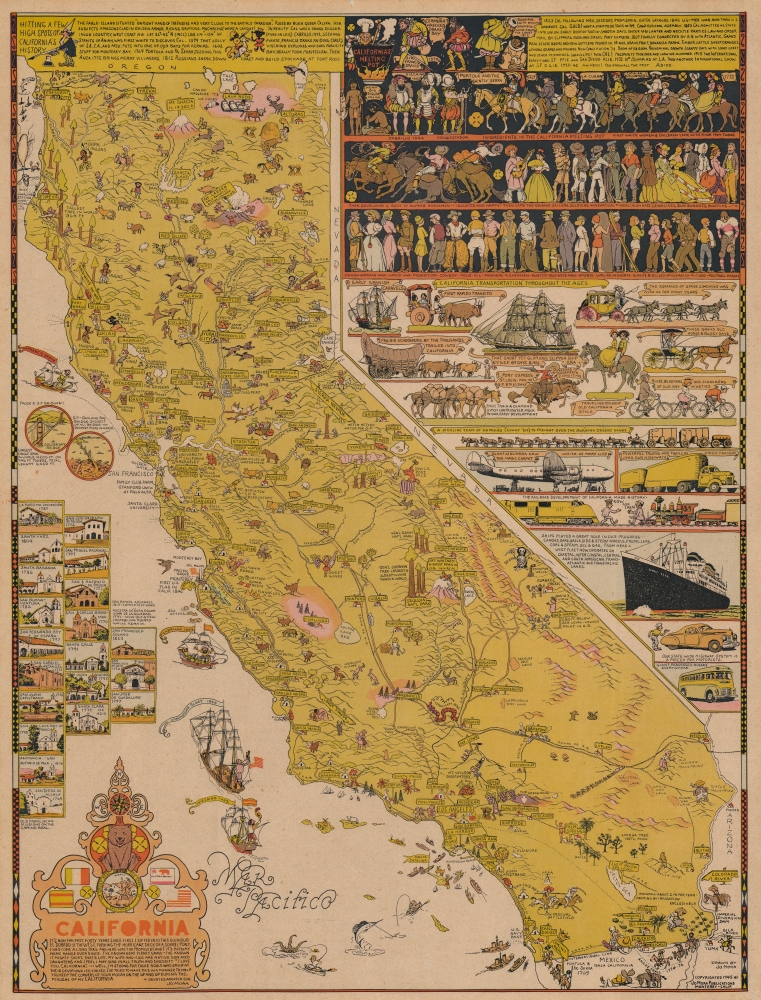
1945 Jo Mora Pictorial Map of California
$1,800.00
1945 Jo Mora Pictorial Map of California
California-jomora-1945$850.00

Title
California.
1945 (dated) 24.5 x 18.5 in (62.23 x 46.99 cm) 1 : 1730000
1945 (dated) 24.5 x 18.5 in (62.23 x 46.99 cm) 1 : 1730000
Description
An intricate, beautiful, and playful 1945 pictorial map of California drawn and published by one of the state's greatest artists of the age, Jo Mora. It provides a whimsical and somewhat sanitized history of the state from the pre-colonial period to the date of publication.
Historical references fill the map, from the text and illustrations of 'California's melting pot' at top to the illustrations of historic Franciscan missions at left and the Camino Real and Anza's Trail through to Mexico at bottom. Contemporary allusions are also present in abundance, such as major cities, airfields, national parks, oil fields, railroads, and irrigation projects. Among these are the Salton Sea, Tulare Lake Bed, replacing the lake which was reduced by agricultural diversion of its source waters, and the L.A. Aqueduct, which had largely dried out Owens Lake by the time of publication. The murals at top-right even combine past and present, with such weighty topics as the Mexican-American War alongside 'football heroes' and 'girlies in shorts.' The title cartouche at bottom-left provides a personalized tribute to the state by 'devoted adopted son' Mora.
A Closer Look
As the map covers the long span of California's history, from the Native American period to the time Mora composed the work, Mora ingeniously employs artistic styles from multiple eras. The dominating method is the pictorial approach popular in the 1930s - 1940s, of which Mora was a master. But more established, realistic motifs appear throughout, while the illustrations at top-right resemble colonial-era murals and the ships, sea creatures, and elaborate text in the Pacific Ocean recall engraved maps of the late 16th and 17th centuries. Typical of pictorial maps of the era, Native Americans ('Injuns') are portrayed in a manner found highly offensive today, though Mora does clearly represent their displeasure with the activities of White settlers. Aside from 'Canby Massacre '73' near Tule Lake in the far north of the state, little evidence is presented of the tremendous violence which accompanied the incorporation of California into the United States of America.Historical references fill the map, from the text and illustrations of 'California's melting pot' at top to the illustrations of historic Franciscan missions at left and the Camino Real and Anza's Trail through to Mexico at bottom. Contemporary allusions are also present in abundance, such as major cities, airfields, national parks, oil fields, railroads, and irrigation projects. Among these are the Salton Sea, Tulare Lake Bed, replacing the lake which was reduced by agricultural diversion of its source waters, and the L.A. Aqueduct, which had largely dried out Owens Lake by the time of publication. The murals at top-right even combine past and present, with such weighty topics as the Mexican-American War alongside 'football heroes' and 'girlies in shorts.' The title cartouche at bottom-left provides a personalized tribute to the state by 'devoted adopted son' Mora.
Publication History and Census
This map was published by Jo Mora in 1945 in Monterey. It is similar to but distinct from his earlier 1927 pictorial map of California (subtitled 'This whimsical Carte of Topographic and Historic intention…). Physical examples of the present map are cataloged among the holdings of ten institutions in the United States, though the intermingling of digital and physical examples in the OCLC makes a precise census difficult.Cartographer
Joseph 'Jo' Jancito Mora (October 22, 1876 – October 10, 1947) was an Uruguayan born artist active in California during the first half of the 20th century. Mora immigrated to California as a young man. He studied art in Boston and, after graduating, worked there briefly before relocating to California. In cartographic circles Mora is known for pioneering the 20th century pictorial map. In a series he referred to as his 'cartes,' published between in 1926 and 1942, Mora developed a pictorial style that combined cartography with colorful cartoonish image of local figures, folklore, history, and natural wonders. His earliest maps were commissioned by the Hotel Del Monte and included California's Playground and The Seventeen Mile Drive. As he matured as a cartographer, his work became increasingly dense, often packed with tiny figures, each expressive of some aspect of regional life. Mora, often called the 'Renaissance man of the West' also worked as an illustrator, muralist, sculptor, photographer, and writer. His masterpiece is considered to be the Father Serra Cenotaph, a bronze and marble sculpture at the Memorial Chapel in El Carmelo Mission, Carmel, California. His map work included Monterey Penninsula (1927), and Seventeen Mile Drive (1927), California (1927), Grand Canyon (1931), Yosemite (1931), Yellowstone (1936), Carmel-By-The-Sea (1942), California (1945) (large and small versions), Map of Los Angeles (1942), among others. More by this mapmaker...
Condition
Good. Pronounced but even toning. One small repaired hole in top margin. Else near fine.
References
Rumsey 6380.000. OCLC 953572603.