1910 Matthews Northrup and Southern Pacific Climate Map of California
California-matthewsnorthrup-1910$400.00

Title
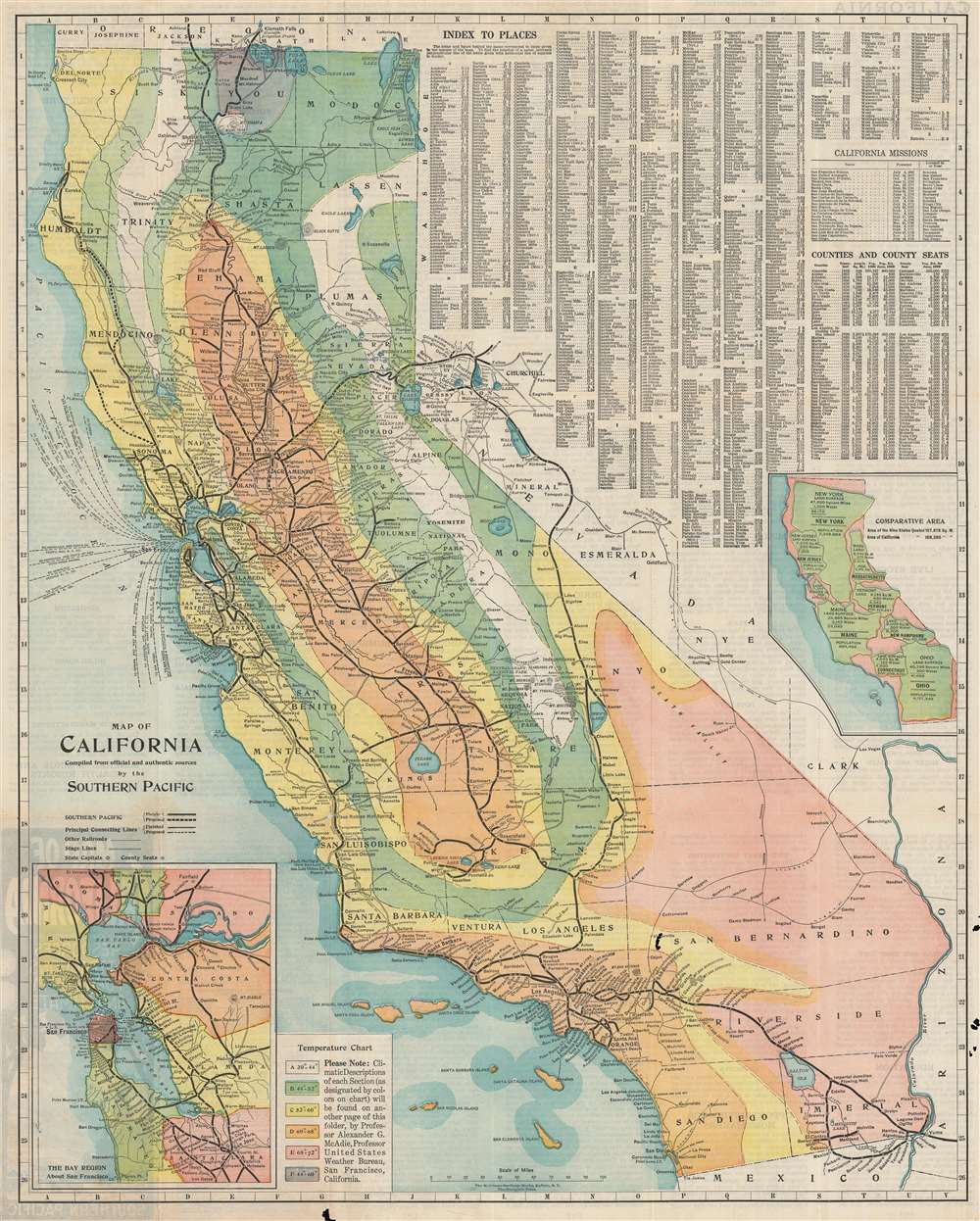
Map of California. Compiled from officiala nd authentic sources by the Southern Pacific.
1910 (undated) 26.25 x 21 in (66.675 x 53.34 cm) 1 : 1700000
1910 (undated) 26.25 x 21 in (66.675 x 53.34 cm) 1 : 1700000
Description
This is a 1910 Matthews Northrup and Southern Pacific climate map of California. The map depicts the region from the Pacific Ocean to Nevada and from Oregon to Arizona and Mexico. Six different colors are used to highlight different average temperature zones within the state, allowing the viewer to form some idea about the climate in any given part of the state. A chart providing the temperature range associated with each color is situated in the lower left corner, next to an inset map of the San Francisco Bay Area. Myriad cities and towns are labeled throughout, but the most detail is included along the thick black lines which represent the route of the Southern Pacific Railroad. The thinner black lines are connecting rail lines. The upper right quadrant is dominated by an index of place names which provides the grid location for innumerable cities and towns in California. A second index provides the names of the counties and the county seats. A second inset map situated along the right border compares other states in the U.S. with California, both in terms of square miles and population.
Publication History and Census
This map was created by Southern Pacific and published by Matthews Northrup in 1910. We are only aware of one institutional example, part of the collection at the Huntington Library.Cartographer
Matthews-Northrup Works (fl. c. 1895 - 1930) were a Buffalo, New York based, in their own words, "writing, designing, engraving, printing, [and] binding" firm. The firm was founded by James Newson Matthews (November 21, 1828 - December 20, 1888) as the J. N. Matthews Company. William Phelps Northrup (April 2, 1850 - February 2, 1929) later joined the company as an apprentice and then partner, at which point the firm was reincorporated as the Matthews-Northrup Works. The Matthews-Northrup Works rose to prominence as publishers and printers of railroad maps, with dozens to their credit. When James died, his shares were inhered by George Edward Matthews (1855 - 1910), who ran the business until his death in 1910. Also in 1910, they famously redesigned the cover of National Geographic Magazine. Despite some six previous cover changes in just 21 years, the Matthews-Northrup layout proved so popular that it was used for nearly 50 years. The firm can also take credit for the Winchell typeface, designed in 1903 under E. E. Winchell's tenure as art director. Curiously, the partners of Matthews-Northrup maintained an unusual affectation in which only the officers of the company could wear beards or mustaches. In this same spirit, the firm also had its own private social club, the Fellowcraft Club, where the all-male employees could relax, play pool, drink and dine. Matthews-Northrup maintained offices on Washington Street, Buffalo, where they were based, as well as Madison Square, New York City, Garden Tower, Boston, and the Citizens Building in Cleveland. More by this mapmaker...
Condition
Good. Closed margin tears professionally repaired on verso. Verso repairs to fold separations. Exhibits loss at some fold intersections and along margins. Text on verso.