This item has been sold, but you can get on the Waitlist to be notified if another example becomes available, or purchase a digital scan.
1881 Mitchell Map of California with Inset of San Francisco and S.F. Bay
California-mitchell-1881$100.00

Title
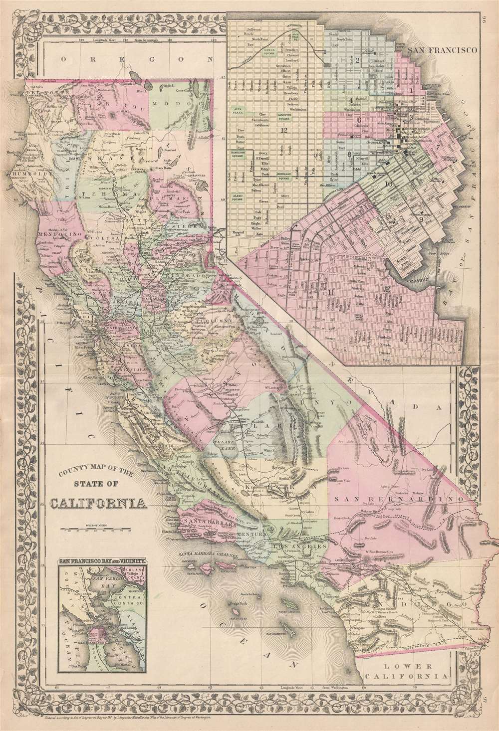
County Map of the State of California.
1881 (dated) 22 x 15 in (55.88 x 38.1 cm) 1 : 2350000
1881 (dated) 22 x 15 in (55.88 x 38.1 cm) 1 : 2350000
Description
This is an 1881 S.A. Mitchell, Jr. map of California. The map depicts the state from the Pacific Ocean to Nevada and from Oregon to Baja California. Highly detailed, myriad cities and towns are labeled throughout the state. Counties are illustrated, labeled, and shaded different colors to allow for easy differentiation. Railroads are indicated by solid black lines, including the Southern Pacific and Central Pacific. Rivers, lakes, and mountains are also noted. An inset map of the city of San Francisco is situated in the upper right corner. Itself a highly detailed map, streets throughout the city are illustrated and labeled, and city wards are numbered and shaded different colors to differentiate between them, just as the counties are on the larger state map. Several buildings within San Francisco are identified, including the U.S. Mint, the opera house, Union Hall, Lincoln Grammar School, and several markets and hotels. An inset map in the lower left corner takes a wider view and depicts the San Francisco Bay Area from Marin County, San Pablo Bay, and Valejo to San Mateo and Point San Matheo.
This map was prepared by S. A. Mitchell Jr. for inclusion in the 1881 edition of Mitchell's New General Atlas.
This map was prepared by S. A. Mitchell Jr. for inclusion in the 1881 edition of Mitchell's New General Atlas.
Cartographer
Samuel Augustus Mitchell (March 20, 1792 - December 20, 1868) began his map publishing career in the early 1830s. Mitchell was born in Bristol, Connecticut. He relocated to Philadelphia in 1821. Having worked as a school teacher and a geographical writer, Mitchell was frustrated with the low quality and inaccuracy of school texts of the period. His first maps were an attempt to rectify this problem. In the next 20 years Mitchell would become the most prominent American map publisher of the mid-19th century. Mitchell worked with prominent engravers J. H. Young, H. S. Tanner, and H. N. Burroughs before attaining the full copyright on his maps in 1847. In 1849 Mitchell either partnered with or sold his plates to Thomas, Cowperthwait and Company who continued to publish the Mitchell's Universal Atlas. By about 1856 most of the Mitchell plates and copyrights were acquired by Charles Desilver who continued to publish the maps, many with modified borders and color schemes, until Mitchell's son, Samuel Augustus Mitchell Junior, entered the picture. In 1859, S.A. Mitchell Jr. purchased most of the plates back from Desilver and introduced his own floral motif border. From 1860 on, he published his own editions of the New General Atlas. The younger Mitchell became as prominent as his father, publishing maps and atlases until 1887, when most of the copyrights were again sold and the Mitchell firm closed its doors for the final time. More by this mapmaker...
Source
Mitchell's New General Atlas, containing maps of the various countries of the World, plans of cities, etc., (1881 edition).
Condition
Very good. Verso repair to centerfold separation. Blank on verso.
References
Rumsey 0592.051 (1884 edition).