This item has been sold, but you can get on the Waitlist to be notified if another example becomes available, or purchase a digital scan.
1786 La Perouse Map of San Francisco, Monterey Bay, California and Oregon
California-perouse-1786$250.00

Title
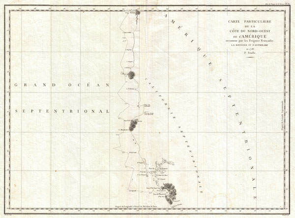
Carte Particuliere de la Cote du Nord-Ouest de l Amerique reconnue par les Fregates Francaises la Boussole et l Astrolabe en 1786. 3e. Feuille.
1786 (dated) 20 x 27 in (50.8 x 68.58 cm)
1786 (dated) 20 x 27 in (50.8 x 68.58 cm)
Description
This is a fine example of La Perouse's important 1787 mapping of the California and Oregon coastlines from Port de Monterey (Monterey Bay) northwards past the Port de St. Francois (San Francsico Bay) and Cape Mendocino to Cap Rond (Tillamook Head, Oregon). Though minimalist this map exhibits one of the most important early surveys of San Francisco Bay. La Perouse spent roughly 10 days surveying San Francisco Bay making numerous improvements over Jose de Canizares' 1776 Plano del Puerto de Sn. Francisco. Skirting the coast, La Perouse also identifies a number of important landmarks including Cape Mendocino, Port de La Trinite, Cap Blanc (Cape Blanco), and others. The route of the La Perouse expedition is noted as it skirts the coast. In its day the importance of this chart went largely unknown for, though the survey work and original engraving date to 1786, the atlas of La Perouse's discoveries was not officially published until 1798, by which time other more advances mappings of the region had reached the mainstream. Nonetheless, this map is a vital addition to any serious collection focusing on the cartographic development of America's western coast.
Cartographer
Jean François de Galaup, Comte de La Pérouse (August 23, 1741 - 1788) was a French naval officer, navigator, and explorer active in the later part of the 18th century. Born into a noble family of Albi, France, La Perouse entered the navel college of Brest at just 15. At seventeen La Perouse made his first naval voyage, a supply expedition to the fort of Louisbourg in New France. He later participated in a number of naval battles, mostly against the English, and eventually rose to the rank of Commodore. In 1782 he captured the English forts Prince of Wales and York, making a name for himself back in France. Following the British defeat at the end of the American Revolutionary War, La Perouse was appointed by Louis XVI to lead an expedition of discovery circumnavigating the globe. The goal of the expedition was to complete and correct the maps of the Pacific drawn by Captain Cook. La Perouse's two frigates, the Astrolabe and the Boussole rounded Cape Horn and entered the Pacific in 1785. Crisscrossing the Pacific from Macau and Japan to Alaska, Vancouver, and the Hawaiian Islands Perouse made numerous discoveries and adding considerably to the cartographic corpus, particularly along the coast of British Columbia and around Japan. In Australia La Perouse sent his last letter back to France containing all of his maps and research. Tragically, on the return voyage La Perouse ran into a violent storm which left both of his frigates shipwrecked on the Polynesian island of Vanikoro, part of the Santa Cruz Group. Some of the survivors of the shipwrecks seem to have managed to live on the island for years afterwards. As late as 1790 the English Captain Edward Edwards saw smoke signals coming from Vanikoro but foolishly declined to investigate. Expeditions in 2005 and in 2008 identified the remains of both ships and retuned numerous artifacts from the ill-fated expedition to France. The importance of La Perouse's discoveries was, unfortunately, not seriously appreciated until many years later because, when the La Perouse maps were finally published in 1797, newer more accurate maps of the region were already in circulation. Nonetheless, La Perouse remains of the titans of Pacific exploration and he work paved the path forward for all future expeditions to the region. More by this mapmaker...
Source
Galaup, J. F. (Comte de La Perouse), Atlas du Voyage de la Perouse, (Paris) 1797.
Condition
Very good. Original centerfold. A nice clean example.