This item has been sold, but you can get on the Waitlist to be notified if another example becomes available, or purchase a digital scan.
1893 Government Map of California and Fillmore Streets, San Francisco
CaliforniaFillmore-supervisors-1893$50.00

Title
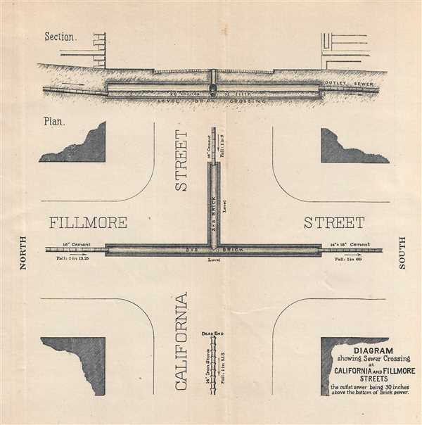
Diagram showing Sewer Crossing at California and Fillmore Streets.
1893 (undated) 7 x 8 in (17.78 x 20.32 cm)
1893 (undated) 7 x 8 in (17.78 x 20.32 cm)
Description
This is an 1893 San Francisco Board of Supervisors map of the intersection of Fillmore and California Streets in San Francisco, California. The map depicts the intersection from the west, with north on the left side to illustrate the sewer crossing underneath the intersection. In detailing the sewer crossing, the board of supervisors appears to be criticizing the mixed construction of both brick and cement sewers in the santiation system. The brick sewers are square, while the cement sewers are circular pipes, creating a mismatching system. A profile view of the intersecting systems is situated above the diagram of the intersection, which illustrates their argument. The outlet sewer was built 30 inches above the bottom of the square brick sewer, which allows '26 inches of filth' to sit in the brick crossing without the possibility of reaching the outlet sewer.
This map was published by order of the San Francisco Board of Supervisors in the 'San Francisco Municipal Reports, 1892-93' and printed by James H. Barry.
This map was published by order of the San Francisco Board of Supervisors in the 'San Francisco Municipal Reports, 1892-93' and printed by James H. Barry.
Source
San Francisco Board of Supervisors, San Francisco Municipal Reports, 1892-93 (San Francisco) 1893.
Condition
Very good. Light wear along original fold lines. Blank on verso.
References
OCLC 815430541.