1849 Colton Map of the American West, w/ California Gold Regions
CaliforniaGold-colton-1849$950.00

Title
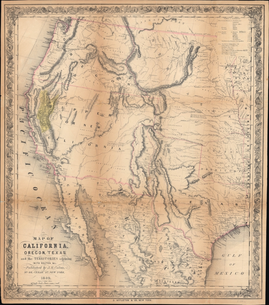
Map of California, Oregon, Texas, and the Territories Adjoining with Routes etc.
1849 (dated) 21 x 18.25 in (53.34 x 46.355 cm) 1 : 6500000
1849 (dated) 21 x 18.25 in (53.34 x 46.355 cm) 1 : 6500000
Description
This is Joseph Hutchins Colton's 1849 map of the American West, highlighting the California gold regions. A fascinating work rewarding close study, it captures a moment of evolving geographic knowledge and cartographic production of the American West in the wake of the Mexican-American War and the California Gold Rush.
Much of the territory of Upper California remained unknown or only barely known to Americans, here often left blank or only noting the existence of various Native American groups. A table of distances at top-right explains the distances involved in several potential routes from New York to California - the most common being that through Panama, followed by the less common routes of sailing to Veracruz or another Mexican port on the Gulf of Mexico, crossing Mexico by land to Acapulco or Tehuantepec, and then sailing to San Francisco, or finally the very hazardous option of crossing the continent overland.
The map is most notable for its early and prominent presentation of the gold regions of California, shaded yellow here. Some placenames would shortly be supplanted: Sacramento for New Helvetia and Sutter Fort, Lake Tahoe for Mountain Lake, Mount Lassen for Mt. St. Joseph, the Truckee River for Salmon Trout River, and, beyond California, Salt Lake City for 'Mormon Fort'. Similarly, ephemeral and descriptive placenames like the 'Quicksilver Mines' south of San Francisco Bay would become more common in the following years. Many Spanish names are retained, especially in Southern California, including Pueblo de Los Angelos.
A Closer Look
The map covers from the U.S.-Canadian border as far south as Zacatecas in Mexico, and from the Pacific Coast to Texas and the Great Plains. It reflects the still-uncertain geographic knowledge and evolving placenames of the vast territory recently acquired by the U.S. in the Mexican-American War (1846 - 1848). The influence of Fremont and Preuss' 1848 'Map of Oregon and Upper California' is evident here, but Colton combines information from several sources, including the Tanner-Mitchell map of Upper California. The U.S.-Mexico border here predates the Gadsden Purchase, while Texas is seen near its greatest extent, covering much of today's New Mexico and southern Colorado and reaching almost to Pikes Peak. New Mexico is presented as a narrow strip of land between the Rio Grande and the 'Sierra de los Mimbres.' The routes of American expeditions led by Kearney and Fremont, as well as the routes taken by the troops of Col. Alexander William Doniphan and Gen. John E. Wool during the Mexican-American War, are traced, as are wagon routes to Santa Fe and Oregon. Aside from waterways and mountains, the occasional settlement or fort is also recorded in the immense Western landscape.Much of the territory of Upper California remained unknown or only barely known to Americans, here often left blank or only noting the existence of various Native American groups. A table of distances at top-right explains the distances involved in several potential routes from New York to California - the most common being that through Panama, followed by the less common routes of sailing to Veracruz or another Mexican port on the Gulf of Mexico, crossing Mexico by land to Acapulco or Tehuantepec, and then sailing to San Francisco, or finally the very hazardous option of crossing the continent overland.
The map is most notable for its early and prominent presentation of the gold regions of California, shaded yellow here. Some placenames would shortly be supplanted: Sacramento for New Helvetia and Sutter Fort, Lake Tahoe for Mountain Lake, Mount Lassen for Mt. St. Joseph, the Truckee River for Salmon Trout River, and, beyond California, Salt Lake City for 'Mormon Fort'. Similarly, ephemeral and descriptive placenames like the 'Quicksilver Mines' south of San Francisco Bay would become more common in the following years. Many Spanish names are retained, especially in Southern California, including Pueblo de Los Angelos.
The California Gold Rush
The discovery of gold at John Sutter's mill by James Wilson Marshall (1810 - 1885) in January of 1848 was one of the most definitive moments in American history. Coming at the end of the Mexican-American War (1846 - 1848), the timing of the discovery could not have been more propitious. The combination of new, seemingly unlimited territory and the lure of gold led to a stampede of adventurers, prospectors, merchants, and homesteaders eager for a new life on the frontier. The Gold Rush was not limited to Americans crossing the Great Plains. European, Australian, and Chinese immigrants rushed into California hungry for their part of the great strike. This great migration transformed the United States in the span of just a few years from a former colony into an expansive transcontinental nation on the cusp of becoming a world power.Publication History and Census
This map was prepared by Colton, printed by James Ackermann, and published by D. Appleton and Company, all in New York City. It appeared in J. Quinn Thornton's book Oregon and California in 1848 and later in some editions of Edwin Bryant's What I Saw in California (with some examples listing 'Harper and Brothers' as the publisher instead of Appleton). As the map was issued as a folding map in a book, surviving examples tend to exhibit considerable wear and toning along the fold lines. The map itself is cataloged in roughly a dozen institutions, while Thornton and Bryant's books are more widespread, though these examples may not include the map.CartographerS
Joseph Hutchins Colton (July 5, 1800 - July 29, 1893), often publishing as J. H. Colton, was an important American map and atlas publisher active from 1833 to 1897. Colton's firm arose from humble beginnings when he moved to New York in 1831 and befriended the established engraver, Samuel Stiles. He worked under Stiles as the 'Co.' in Stiles and Co. from 1833 to 1836. Colton quickly recognized an emerging market in railroad maps and immigrant guides. Not a cartographer or engraver himself, Colton's initial business practice mostly involved purchasing the copyrights of other cartographers, most notably David H. Burr, and reissuing them with updated engraving and border work. His first maps, produced in 1833, were based on earlier Burr maps and depicted New York State and New York City. Between 1833 and 1855, Colton proceeded to publish a large corpus of guidebooks and railroad maps, which proved popular. In the early 1850s, Colton brought his two sons, George Woolworth Colton (1827 - 1901) and Charles B. Colton (1832 - 1916), into the map business. G. W. Colton, trained as a cartographer and engraver, was particularly inspired by the idea of creating a large and detailed world atlas to compete with established European firms for the U.S. market. In 1855, G.W. Colton issued volume one of the impressive two-volume Colton's Atlas of the World. Volume two followed a year later. Possibly because of the expense of purchasing a two-volume atlas set, the sales of the Atlas of the World did not meet Colton's expectations, and so, in 1856, the firm also issued the atlas as a single volume. The maps contained in this superb work were all original engravings, and most bear an 1855 copyright. All of the maps were surrounded by an attractive spiral motif border that would become a hallmark of Colton's atlas maps well into the 1880s. In 1857, the slightly smaller Colton's General Atlas replaced the Atlas of the World. Most early editions of the General Atlas published from 1857 to 1859 do not have the trademark Colton spiral border, which was removed to allow the maps to fit into a smaller format volume. Their customers must have missed the border because it was reinstated in 1860 and remained in all subsequent publications of the atlas. There were also darker times ahead; in 1858, Colton was commissioned at a sum of 25,000 USD by the government of Bolivia to produce and deliver 10,000 copies of a large format map of that country. Although Colton completed the contract in good faith, delivering the maps at his own expense, he was never paid by Bolivia, which was at the time in the midst of a series of national revolutions. Colton would spend the remainder of his days fighting with the Bolivian and Peruvian governments over this payment, and in the end, after a congressional intervention, he received as much as 100,000 USD in compensation. Nonetheless, at the time, it was a disastrous blow. J. H. Colton and Company is listed as one of New York's failed companies in the postal record of 1859. This led Colton into the arms of Alvin Jewett Johnson and Ross C. Browning. The 1859 edition of Colton's General Atlas lists Johnson and Browning as the 'Successor's to J. H. Colton' suggesting an outright buyout, but given that both companies continued to publish separately, the reality is likely more complex. Whatever the case may have been, this arrangement gave Johnson and Browning access to many of Colton's map plates and gave birth to Johnson's New Illustrated (Steel Plate) Family Atlas. The Johnson's Atlas was published parallel to Colton's atlases well into the 1880s. The Colton firm itself subsequently published several other atlases including an Atlas of America, the Illustrated Cabinet Atlas, the Octavo Atlas of the Union, and Colton's Quarto Atlas of the World. They also published a large corpus of wall maps, pocket maps, and guides. The last known publications of the Colton firm date to 1897 and include a map and a view, both issued in association with the Merchant's Association of New York. Alice M. Colton married August R. Ohman (May 3, 1859 - April 22, 1934) on January 5, 1897. In 1898, Ohman joined the Colton firm, which continued to publish as Colton, Ohman & Co. until 1901. More by this mapmaker...
D. Appleton (fl. 1830 - 1873) was a New York based map publisher operating in the middle part of the 19th century. His most common publications were school geography texts published under his own name or the name of his associate S. S. Cornell. He also published a series of pocket maps relating to the Civil War and a few lesser known wall maps. Learn More...
James Ackerman (1816 - March 24, 1864) was an American painter, engraver, and lithographer active in New York City in the mid-19th century. Ackerman was born in New York. He rose to prominence as a lithographer and painter - best known for his floral prints, some of which were favorably lauded by none other than Edgar Allen Poe. He was also associated with the banner and sign painting firm of Ackerman and Miller until his death. His offices were at 120 Fulton Street and later at 379 Broadway. He frequently printed for the U.S. government, including work for the U.S. Coast Survey and the General Land Office. I have found few references to what happened to Ackerman later in life, but his residence at death is identified as the Bloomingdale Insane Asylum. Ackerman is interred in Brooklyn at Greenwood Cemetery. Learn More...
Condition
Fair. Area of infill along bottom to the left of center extending 2.5 inches into printed area. Verso repairs to fold separations and at fold intersections. Closed tear extending .5 inch into upper border professionally repaired on verso.
References
OCLC 81161315, 855800671, 1328798807. Wheat, C., Mapping the Trans-Mississippi West, #593; Wheat, C., Maps of the California Gold Region, #73.