1700 De Fer Map of Insular California and Mexico
californienouveaumexique-defer-1700-2$1,400.00

Title
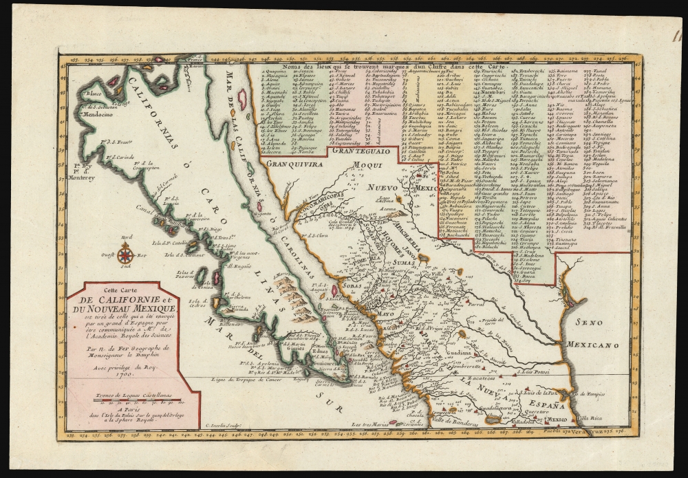
Cette Carte de Californie et du Nouveau Mexique...
1700 (dated) 9 x 13.5 in (22.86 x 34.29 cm) 1 : 13300000
1700 (dated) 9 x 13.5 in (22.86 x 34.29 cm) 1 : 13300000
Description
A landmark 1700 map showing California as an island and the first published dissemination of Fr. Eusebio Kino's groundbreaking explorations in New Mexico and California.
A Closer Look
Drawn by Nicolas de Fer, official Geographe de Monseigneur le Dauphin, this map covers from Cape Mendocino (California) to the Gulf of Mexico and the mouth of the Mississippi River (as erroneously placed, by Hennepin, in the vicinity of Galveston Bay) and from Santa Fe to Mexico City. Place names are identified textually and numerically, referencing a table of 314 locations in the upper right.The State of the Art
As the title suggests, De Fer based this map on documents sent to the Monsieur Regis at the Paris Academie Royale des Sciences by a 'Spanish Grandee.' This most likely refers to Carlos de Siguenza y Gongora, the Spanish Royal Geographer in Mexico City, who prepared a manuscript version of Kino's map in 1696 (a copy of this manuscript survives in the Jesuit Library of Rome). The original missive was most likely intended for Guillaume Delisle, a highly respected French cartographer who held the title of Geographe du Roi. However, as Geographe de Monseigneur le Dauphin, De Fer would also have had access, a fact on which he was quick to capitalize. Thus, some cartographic historians have considered this map the 'first pirated copy' of Kino's work. However, close examination reveals that, while Kino's explorations form its essence, De Fer's map stands alone as a separate piece - a synthesis of Kino's new information with the established model for the mapping of the west.California as an Island
The idea of an insular California first appeared as a work of fiction in Garci Rodriguez de Montalvo's c. 1510 romance Las Sergas de Esplandian; subsequent exploration of the region by the Spanish revealed a peninsular Baja, and this mapping stood for many years. However, beginning in 1624, maps produced by the English and the Dutch began to promote the idea that California was an island. By the middle of the century, French geographer Nicolas Sanson added his authority to the myth. California's insularity was thus established cartographic canon by the time De Fer's map was produced.Hennepin's Mississippi
The Mississippi River here enters the Gulf of Mexico at the eastern extreme of this map, significantly west of its actual mouth. Although by 1700, La Salle had successfully located the mouth of the Mississippi, De Fer's map reflects the earlier Hennepin model. This had the effect - likely deliberate - of dramatically expanding French Louisiana and showing the proximity of French territory to the rich silver mines of central Mexico - a fact that would not have been lost on either the French King or De Fer's personal patron the Dauphin.Pre-Kino Cartography
Where De Fer draws from earlier maps, he identifies these elements textually. These include major cities in Mexico, Santa Fe, Mexico City, Compostella, Culiacan, St. Luis Potosi, Sombrette, and Sinaloa, among others. Situated to the north and west of Santa Fe are Gran Teguaio and Gran Quivira, speculative Kingdoms of Gold derived from Spanish legend and conquistador reports.Publication History and Census
This map was engraved by Charles Inselin for inclusion in De Fer's L'Atlas Curieux ou le Monde. It was also published in De Fer's 1701 Cartes et Descriptions Generales et Particulieres ... d'Espagne. This map exists in two states, this being the first. The only notable difference between the two is the date change, 1700 to 1705, in the title cartouche.CartographerS
Nicholas de Fer (1646 - October 25, 1720) was a French cartographer and publisher, the son of cartographer Antoine de Fer. He apprenticed with the Paris engraver Louis Spirinx, producing his first map, of the Canal du Midi, at 23. When his father died in June of 1673 he took over the family engraving business and established himself on Quai de L'Horloge, Paris, as an engraver, cartographer, and map publisher. De Fer was a prolific cartographer with over 600 maps and atlases to his credit. De Fer's work, though replete with geographical errors, earned a large following because of its considerable decorative appeal. In the late 17th century, De Fer's fame culminated in his appointment as Geographe de le Dauphin, a position that offered him unprecedented access to the most up to date cartographic information. This was a partner position to another simultaneously held by the more scientific geographer Guillaume De L'Isle, Premier Geograph de Roi. Despite very different cartographic approaches, De L'Isle and De Fer seem to have stepped carefully around one another and were rarely publicly at odds. Upon his death of old age in 1720, Nicolas was succeeded by two of his sons-in-law, who also happened to be brothers, Guillaume Danet (who had married his daughter Marguerite-Geneviève De Fer), and Jacques-François Bénard (Besnard) Danet (husband of Marie-Anne De Fer), and their heirs, who continued to publish under the De Fer imprint until about 1760. It is of note that part of the De Fer legacy also passed to the engraver Remi Rircher, who married De Fer's third daughter, but Richer had little interest in the business and sold his share to the Danet brothers in 1721. More by this mapmaker...
Charles Inselin (fl. c. 1700 - 1730) was a prominent French engraver active in Paris during the late 17th and early 18th centuries. Inselin engraved for prominent cartographers ranging from Nicholas Sanson to Eusebio Kino and Nicholas De Fer. He was also a minor publisher of maps and engravings on his own account. Little else is known of his life. Learn More...
Source
Fer, Nicholas de, L'Atlas Curieux ou le Monde, (Paris) 1700.
Condition
Very good. Marginal reinstatement and mended tear at bottom, no loss.
References
OCLC 28249974. McLaughlin, G., The Mapping of California as an Island: An Illustrated Checklist, #134.