This item has been sold, but you can get on the Waitlist to be notified if another example becomes available, or purchase a digital scan.
1852 Grassl Map of Texas and California w/ California Gold Region and early Texas
CalifornienTexas-grassl-1852-3$325.00

Title
Vereinigte Staaten von Nord-America: Californien, Texas und die Territorien New Mexico u. Utah.
1852 (dated) 9 x 11 in (22.86 x 27.94 cm) 1 : 9504000
1852 (dated) 9 x 11 in (22.86 x 27.94 cm) 1 : 9504000
Description
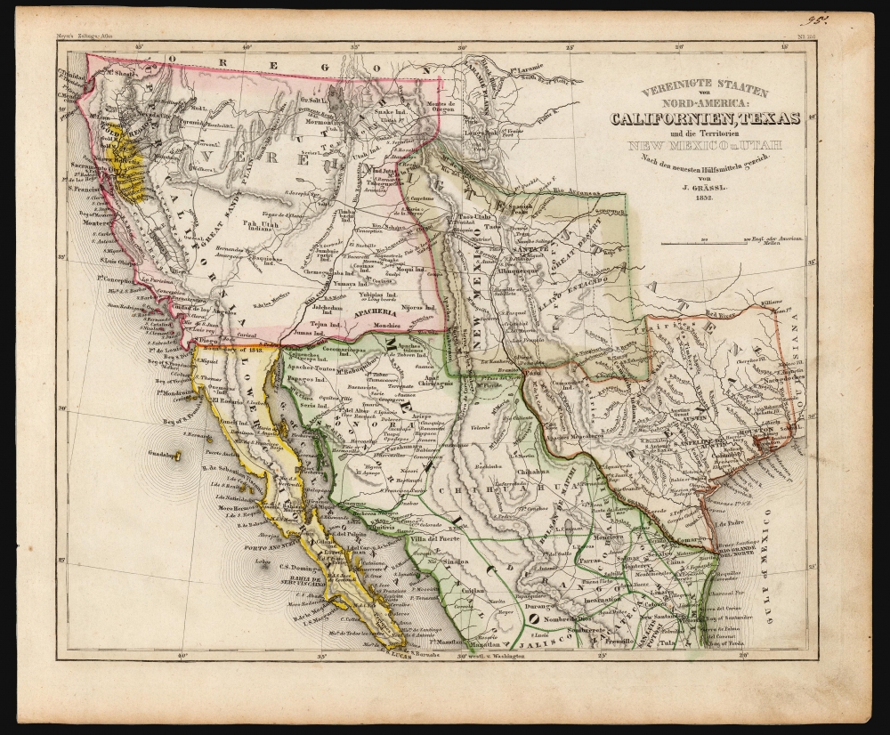
An uncommon and under-appreciated 1852 map of the American southwest and northern Mexico by Joseph Grassl and Joseph Meyer. It is most notable for its anachronistic and unusual presentation of the borders of New Mexico and Texas, and other cartographic oddities.
New Mexico's petition for statehood appeared before the U.S. Congress during a period of extraordinary contention and rivalry. First, much of the territory claimed by the first New Mexico Constitution was also claimed by Texas - in fact, the original Texas border (terminating just east of the Sierra de Mimbres) is marked on this map, but not colorized. The second issue, one of slavery, made the creation of a New Mexico state a national issue with broad ramifications - especially as it intended to enter the Union as a free state. The Compromise of 1850 forced Texas to give up (or, more accurately, sell) its claims along the Rio Grande as well as its northern extension, thereby placing it below the Missouri Compromise Line and entering the Union as a slave state. New Mexico, meanwhile, was entered as a territory without congressional voting rights and thus committed as neither a free nor slave state. The Compromise also established the western border of the New Mexico Territory roughly along today's California-Arizona border; however, the results of the Compromise are not shown here.
One can only wonder at the cartographer's intentions in rendering New Mexico according to the early constitutional boundaries rejected by Congress over two years earlier. While it is conceivable that Grassl was merely copying from outdated material, such as the 1828 Tanner map of Mexico, we think it unlikely, as he would have been aware of events in United States, and using outdated sources is inconsistent with his other, generally meticulous work. It is more likely that Grassl was carto-advocating for an anti-slavery position and playing to his generally abolitionist German audience by showing support for the rejected New Mexico Constitution. In the mid-19th century, there was a great deal of European interest in the western parts of the United States as a land of opportunity and new beginnings - especially in Germany from which vast numbers emigrated to the United States, in particular to Texas and the greater southwest.
A Closer Look
The map covers the greater southwest from the 42nd parallel south, including modern-day California, Utah, Nevada, Arizona, New Mexico, Texas, Colorado, and northern Mexico. Rivers, lakes, mountains, and other geographic features are noted, as are Native American tribes, cities, major roads, and railways. States and territories are divided by hand-colored borders, and the California Gold Region is appropriately shaded bright yellow.Unconventional Cartography
Grassl presents an early configuration of this region rarely seen on maps - this is the only map post-dating the Mexican-American War (1846 - 1848) we are aware of to depict a pre-Compromise of 1850 configuration of the Territory of New Mexico, which takes center stage. The borders here are based on an early bid for New Mexico statehood as a Free State filed with the U.S. Congress early in 1850. The bid followed the first New Mexico Constitution, approved by the State Assembly in the same year, which roughly conformed to the borders traditionally given to the former Mexican Intendencia of Santa Fe, which extended eastward to about 100 degrees, northwards as far as the Arkansas River, and westward to just beyond the Sierra de Mimbres, a southern extension of the Rocky Mountains.New Mexico's petition for statehood appeared before the U.S. Congress during a period of extraordinary contention and rivalry. First, much of the territory claimed by the first New Mexico Constitution was also claimed by Texas - in fact, the original Texas border (terminating just east of the Sierra de Mimbres) is marked on this map, but not colorized. The second issue, one of slavery, made the creation of a New Mexico state a national issue with broad ramifications - especially as it intended to enter the Union as a free state. The Compromise of 1850 forced Texas to give up (or, more accurately, sell) its claims along the Rio Grande as well as its northern extension, thereby placing it below the Missouri Compromise Line and entering the Union as a slave state. New Mexico, meanwhile, was entered as a territory without congressional voting rights and thus committed as neither a free nor slave state. The Compromise also established the western border of the New Mexico Territory roughly along today's California-Arizona border; however, the results of the Compromise are not shown here.
One can only wonder at the cartographer's intentions in rendering New Mexico according to the early constitutional boundaries rejected by Congress over two years earlier. While it is conceivable that Grassl was merely copying from outdated material, such as the 1828 Tanner map of Mexico, we think it unlikely, as he would have been aware of events in United States, and using outdated sources is inconsistent with his other, generally meticulous work. It is more likely that Grassl was carto-advocating for an anti-slavery position and playing to his generally abolitionist German audience by showing support for the rejected New Mexico Constitution. In the mid-19th century, there was a great deal of European interest in the western parts of the United States as a land of opportunity and new beginnings - especially in Germany from which vast numbers emigrated to the United States, in particular to Texas and the greater southwest.
Californien
Also of interest is Grassl's presentation of the California gold region. Though by 1852, most American maps no longer highlighted the gold region, Grassl is once again catering to his primarily Germanic audience by presenting the American West as a land of wealth and opportunity. He identifies 'Nueva Helvetica' in this region. Nueva Helvetia, or New Switzerland, was a Mexican-era settlement established near Sacramento by Swiss pioneer John Sutter. It was here that James Marshall, one of Sutter's most trusted employees, made the historic gold discovery at Sutter's Mill.Publication History and Census
This map was prepared by Joseph Grassl (also rendered as Graessl or Grässl), about whom little is known, in 1852 for issue in Joseph Meyer's Neuster Zeitungs Atlas. The map is independently cataloged by Southern Methodist University, the Houston Public Library, the Huntington Library, the University of California Berkeley, the University of New Mexico, the University of Texas-Arlington, and Texas Tech University, as well as five institutions in Germany.Cartographer
Joseph Meyer (May 9, 1796 - June 27, 1856) was a German industrialist, merchant, and publisher, active in Germany in the early to mid 19th century. He is best known for publishing the encyclopedia Meyers Conversation-Lexicon. Born in Gotha, Germany, Meyer was educated as a merchant in Frankfurt am Main. He moved to London in 1816, but returned to Germany in 1820 after his stock speculations and business adventures fell through. Once back in Germany, he began by investing in the textile trade (1820 - 24). Meyer began creating business plans concerning how to start railways soon after the first steam-hauled railway began operation in December 1835. He founded the Deutsche Eisenbahnschienen-Compangie auf Actien (German Railway Rail joint stock company) in 1845. Meyer also found great success as a publisher, utilizing the system of serial subscriptions to publications, a new idea for the time. He founded a company, Bibliographisches Institut in Gotha in 1825, which published several versions of the Bible, works of classical literature, atlases, the world in pictures on steel engravings, and an encyclopedia. He moved the Institut from Gotha to Hildburghausen in 1828. He published several atlases, including Meyer's Groẞer Hand-Atlas (1843 - 1860). In 1848, he supported the Springtime of the Peoples Revolutions that took place throughout Germany and much of Europe. When the revolutions failed in 1849, Meyer was briefly imprisoned for his support of revolutionary activities. The revolutions also began to take a toll on Meyer's business interests, and when he died, in 1856, the Bibliographisches Institut was struggling financially. His son, Herrmann Julius Meyer, took over the firm, spearheading a rapid recovery. This, and other businesses prospered under Herrmann Julius (April 4, 1826 - March 12, 1909) and when he died in 1909, he led the richest family in Saxony, with more total wealth than the King of Saxony More by this mapmaker...
Source
Meyer, J., Neuster Zeitungs-Atlas Fuer Alte und Neue Erdkunde, (Heidelberg: Meyer) 1852.
Meyer's Zeitung Atlas, formally titled Neuster Zeitungs-Atlas Fuer Alte und Neue Erdkunde was a popular German hand-atlas published in Heidelberg by Joseph Meyer between, roughly, 1848 and 1859. The atlas is well engraved in the German style with exceptionally dense detail and minimal decoration. Meyer's Atlas, and its constituent maps, are typically very difficult to date as later editions often contain earlier maps and earlier editions later paste-in updates. That said, the atlas' frequent updates and publication run during a turbulent decade provide a noteworthy cartographic record of the period.
Condition
Very good. Even toning, else excellent with original wash and outline color.
References
OCLC 44437918. Wheat, C. I., The Maps of the California Gold Region, 1848-1857, a Biblio-Cartography of an Important Decade, 217.