1948 Lee Pictorial Map of Cambridge, England
Cambridge-lee-1948$550.00

Title
Cambridge.
1948 (undated) 18 x 23 in (45.72 x 58.42 cm)
1948 (undated) 18 x 23 in (45.72 x 58.42 cm)
Description
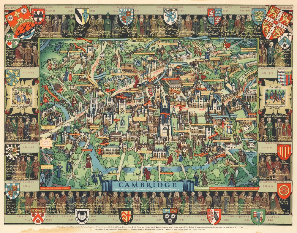
This is a marvelous c. 1948 Kerry Lee pictorial map of Cambridge, England. Charmingly illustrating the world-famous university town, yellow panels mark the city's colleges, including Christ's College, King's College, St. John's College, Trinity College, and Queen's College. Banners highlight other important locations, including chapels, theaters, markets, gates, and The Pepysian Library. Famous personalities walk the streets of Cambridge, including Isaac Newton, William Wordsworth, Lord Keynes, Francis Bacon, Geoffrey Chaucer, and King Henry VIII and Anne Boleyn. Coats of Arms for the city's colleges adorn the border and state when each college was founded. 'Portraits' of famous alumni populate the rest of the border.
Publication History and Census
This map was drawn by Kerry Lee (who appears on the lower right with his dog Jim) and was published by Lee's company, Pictorial Maps Ltd., 'for the Travel Association of Great Britain and N. Ireland (Tourist Division of the British Tourist and Holidays Board)'. It was printed in Great Britain by Chromoworks Ltd. There are at least two editions. One published for the U.K. market, and another, as here, published for the Travel Association of Great Britain and N. Ireland to encourage tourism in the U.K.Cartographer
Kerry Ernest Lee (December 4, 1902 - February, 1988) was a British commercial illustrator, artist, and publisher of pictorial maps active in the middle part of the 20th century. Lee was the founder of the London based Pictorial Maps Ltd. He was born in West Ham, Essex, England. Lee's earliest pictorial map work dates to about 1940, when he produced a pictorial map of Scandinavia During World War II, Lee was one of several artist who created dramatic military-educational cut-away images of German aircraft and war maps for the Air Intelligence branch of MI6, A.I.2. After the war, in 1946, he founded Pictorial Maps Ltd. to publish a series of historical and pictorial maps of popular English cities, among them Oxford, Cambridge, London, Stratford-upon-Avon, Birmingham, and Liverpool. He included comic self-portraits illustrating he and his dog Jim in many of the maps. The images proved popular and many were reprinted for sale in the United States by the Travel Association. The firm also employed other artists, including Denis M. Jones. Lee died in Dacorum, Hertfordshire, England. More by this mapmaker...
Condition
Good. Scuffing to copyright statement along bottom border else printed image untouched. Soiling to margins.