1897 Garcia Cubas Map of Campeche
Campeche-garciacubas-1897$500.00
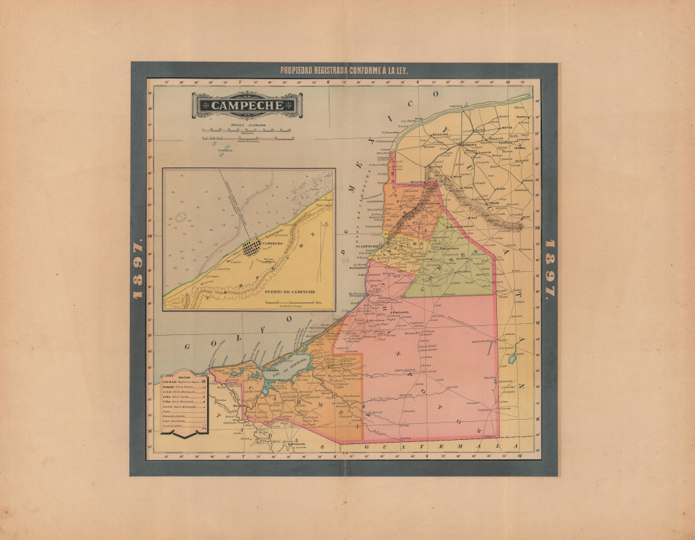

Title
Campeche.
1897 (dated) 15.75 x 16.25 in (40.005 x 41.275 cm) 1 : 1200000
1897 (dated) 15.75 x 16.25 in (40.005 x 41.275 cm) 1 : 1200000
Description
An appealing map of Campeche state, Mexico, published in 1897 in the Atlas Geográfico de los Estados Unidos Mexicanos.
At left, a large inset map and nautical chart of the state's eponymous capital city and main port is included. Due to its well-preserved city walls and architecture, as well as its importance to the history of Caribbean piracy, the historic core of Campeche was declared a UNESCO World Heritage Site in 1999.
The region's economy in the late 19th century was driven by exports, especially products of the distinctive local plant Haematoxylum campechianum, which was used widely for creating dyes in the European textile industry.
A Closer Look
Campeche is one of Mexico's easternmost states, on the Yucatán Peninsula. Characteristic of maps in the Atlas Geográfico, towns and cities, haciendas, ranchos, historical and (Mayan) archaeological sites ('abandoned places'), roads (including a projected road to Bacalar), waterways, mountains, and administrative divisions are indicated. As with the atlas as a whole, longitude is measured from a Prime Meridian at Mexico City.At left, a large inset map and nautical chart of the state's eponymous capital city and main port is included. Due to its well-preserved city walls and architecture, as well as its importance to the history of Caribbean piracy, the historic core of Campeche was declared a UNESCO World Heritage Site in 1999.
Contesting Campeche
Campeche state is a relatively recent creation, having been a part of Yucatán state until the latter attempted to form an independent republic in the 1820s. As a result of the decades-long struggle of the federal government to crush separatism, the state of Campeche was created in 1862. On top of this was a political rivalry between liberal Campeche city and more conservative Mérida (at top-right), as well as tensions between the indigenous population and Spanish-descended settlers, which led to several conflicts and revolts throughout the 19th century.The region's economy in the late 19th century was driven by exports, especially products of the distinctive local plant Haematoxylum campechianum, which was used widely for creating dyes in the European textile industry.
Publication History and Census
This map was published in Mexico City in 1897 by Vega y Cie. It is based on the 1887 work of Antonio García Cubas, and was updated with additional border work for the 1897 issue of the Atlas Geográfico de los Estados Unidos Mexicanos. The atlas is represented in several institutional collections but is extremely scarce on the market. The individual maps, likewise, are scarce to the market.Cartographer
Antonio Garcia y Cubas (July 24, 1832 - February 9, 1912) was a Mexican cartographer, writer, engineer, and geographer active in Mexico City in the second half of the 19th and the early 20th centuries. He is considered Mexico's first great geographer. Garcia y Cubas was born in Mexico City. He was orphaned at birth and was raised by is aunt. When he turned 18, he enrolled in the Dirección General de Industria, a government sponsored technical school. There he studied engineering and geography, which he further pursued at the Colegio de San Gregorio, Colegio de Ingenieros. He graduated with honors in geography and from 1856, became a member of the Sociedad Mexicana de Geografía y Estadística. His geographical work earned him the Order of Guadalupe, a Mexican second empire honorific, directly from the Emperor Maximillian. He published several atlases, including his important Atlas Geográfico, Estadístico e Histórico de la República Mexicana, and multiple decorative chromolithograph Atlas Pintoresco e Históricos covering Mexico, Cuba, Spain, and elsewhere. Today his work is scarce and highly desirable. More by this mapmaker...
Source
García Cubas, Antonio, Atlas Geográfico de los Estados Unidos Mexicanos, (Mexico City: Vega) 1897.
Atlas Geográfico de los Estados Unidos Mexicanos is a grand-format folio atlas of Mexico. It is based largely upon the Atlas Geográfico y Estadístico de los Estados Unidos Mexicanos published in 1887 by Antonio García Cubas and Debray. The present atlas incorporates the same maps, but adds a dramatic silver and gold border, which obscures the 1886 García Cubas imprint. It was issued during Porfirio Díaz's third term as president of Mexico - a period marked by rapid expansion of infrastructure and industry, including railroads, mines, bridges, roads, and broad scale electrification and waterworks. The atlases title page in this 1897 edition, celebrates Diaz with a large portrait and dedication. We have identified at least two editions of this atlas, both bearing the 1897 date: one by Cadena y Cie, features a red title page, another by Vega y Cie, featuring a blue title page. All 1897 editions we have identified have the silver borders, but these seem to be overprinted to cover an earlier gold border, with unidentifiable text and dating behind. We have been unable to find any examples with only the gold border. The atlases in general are showpieces of Mexican lithography in the golden age of the Porfiriato.
Condition
Very good. Centerfold separation repaired and reinforced on verso. Closed margin tear professionally repaired on verso.
References
Rumsey 5758.008 (1886 edition).