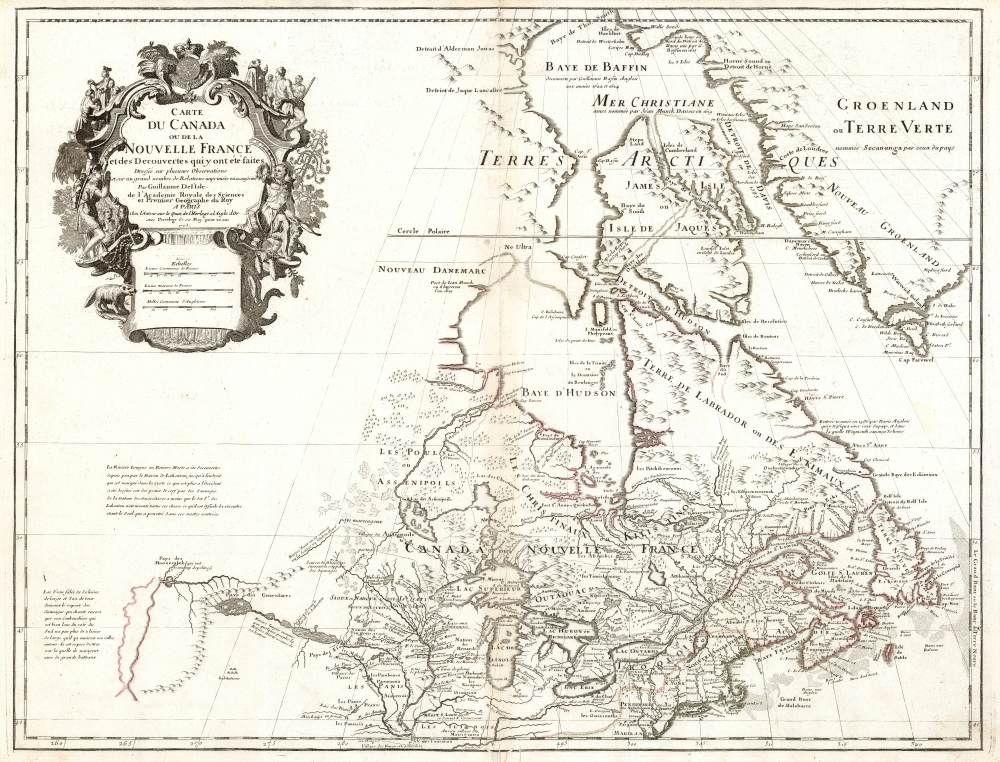
1718 De L'Isle Map of Canada, the Great Lakes, and New England
Canada-delisle-1703$1,800.00

Title
Carte du Canada ou de la Nouvelle France et des Decouverts qui y ont été faites...
1703 (dated) 19.5 x 25.5 in (49.53 x 64.77 cm) 1 : 9000000
1703 (dated) 19.5 x 25.5 in (49.53 x 64.77 cm) 1 : 9000000
Description
This is Guillaume de l'Isle's groundbreaking map of Canada - one of the most important maps of the north parts of North America. When De l'Isle first issued this map in 1703, it was the most sophisticated cartographic representation of this region yet published, referencing various elements from the most recent explorations including the Jesuit Relations, Pierre Le Moyne d'Ibervile, Pierre Le Sour, and Baron de Lahontan.
Lahontan's work has been both dismissed as fantasy and defended as erroneous speculation by various scholars. It is entirely possible that Lahontan faithfully described indigenous reports of the Great Salt Lake, or even the distant Pacific. But De l'Isle himself noted the possibility that 'Mr. Lahontan has invented all of these things, which is difficult to resolve, he being the only one to penetrate this vast country.'
A Closer Look
This map proved highly influential and was one of the best maps of this region until the explorations of the late 18th and early 19th century. This example, updated with the mapmaker's new title as Royal Geographer, was printed in Paris in about 1718. Coverage extends south to include the part of the United States north of the Chesapeake, including all five of the Great Lakes and New England, but De l'Isle's primary focus is on the French territory of Canada, including Hudson Bay, Baffin Bay and a large part of Greenland.Kershaw's Praise
According to the map historian Kenneth Andrew Kershaw, this isOne of the most outstanding maps of Canada of the 17th and early 18th centuries ... De l'Isle's careful research resulted in the first map of Canada to present the whole of the Great Lakes correctly. In addition, the position of the lakes relative to Hudson's Bay is also correct, and the Avalon Peninsula is shown much more realistically than on previous maps of Canada. Of considerable significance, the geography of the coastal regions of James and Hudson Bays, together with their major river systems, is presented by De l'Isle with a surprising degree of accuracy.
Baron Louis Armand de Lahontan
One of this map's most intriguing elements is De L'Isle's treatment of the speculative explorations of the Baron Louis Armand de Lahontan, which dominate the lower left. Lahontan (1666 - 1715) was a French military officer commanding the fort of St. Joseph, near modern-day Port Huron, Michigan. Abandoning his post to live and travel with local Chippewa tribes, Lahontan claims to have explored much of the Upper Mississippi Valley and discovered a previously unknown river, which he dubbed the 'Longue River'. This river he claims to have followed a good distance from its convergence with the Mississippi. Beyond where he personally traveled, Lahontan wrote of further lands along the river described by his American Indian guides. These include a great saline lake or sea (ghosted in here) at the base of a low mountain range. This range, he reported, could be easily crossed, and from this point, further rivers flowed westward to the mysterious lands of the Mozeemleck and, presumably, the Pacific.Lahontan's work has been both dismissed as fantasy and defended as erroneous speculation by various scholars. It is entirely possible that Lahontan faithfully described indigenous reports of the Great Salt Lake, or even the distant Pacific. But De l'Isle himself noted the possibility that 'Mr. Lahontan has invented all of these things, which is difficult to resolve, he being the only one to penetrate this vast country.'
A Beautiful and Revealing Cartouche
Despite the general trend towards simpler decorative elements in De l'Isle's work, the cartouche for this map - the work of Nicholas Guérard - is beautifully engraved. It is flanked with images of Native Americans - one woman with a papoose on her back, and a fierce warrior displaying a scalp. In a nod to the predominance of Jesuit sources for French geography in the region, the cartouche also includes vignettes of missionaries preaching to the Natives. The cartouche also features Canadian fauna, including an alarming beaver, while a goose lurks in the shadows.Publication History and Census
This map was compiled by Guillaume de l'Isle, who first published it in 1703. This is the c. 1718 5th state of that first plate, engraved and printed in Paris. In its various editions, the map is well represented in institutional collections.CartographerS
The De L'Isle family (fl. c. 1700 - c. 1760) (also written Delisle) were, in composite, a mapmaking tour de force who redefined early 18th century European cartography. Claude De L'Isle (1644 -1720), the family patriarch, was Paris based a historian and geographer under Nicholas Sanson. De L'Isle and his sons were proponents of the school of "positive geography" and were definitive figures, defining the heights of the Golden Age of French Cartography. Of his twelve sons, four, Guillaume (1675 - 1726), Simon Claude (1675 - 1726), Joseph Nicholas (1688 - 1768) and Louis (1720 - 1745), made a significant contributions to cartography. Without a doubt Guillaume was the most remarkable member of the family. It is said that Guillaume's skill as a cartographer was so prodigious that he drew his first map at just nine years of age. He was tutored by J. D. Cassini in astronomy, science, mathematics and cartography. By applying these diverse disciplines to the vast stores of information provided by 18th century navigators, Guillaume created the technique that came to be known as "scientific cartography", essentially an extension of Sanson's "positive geography". This revolutionary approach transformed the field of cartography and created a more accurate picture of the world. Among Guillaume's many firsts are the first naming of Texas, the first correct map of the Mississippi, the final rejection of the insular California fallacy, and the first identification of the correct longitudes of America. Stylistically De L'Isle also initiated important changes to the medium, eschewing the flamboyant Dutch style of the previous century in favor of a highly detailed yet still decorative approach that yielded map both beautiful and informative. Guillaume was elected to the French Academie Royale des Sciences at 27. Later, in 1718, he was also appointed "Premier Geographe du Roi", an office created especially for him. De L'Isle personally financed the publication of most of his maps, hoping to make heavy royalties on their sales. Unfortunately he met an untimely death in 1728, leaving considerable debt and an impoverished child and widow. De L'Isle's publishing firm was taken over by his assistant, Phillipe Buache who became, posthumously, his son in law. The other De L'Isle brothers, Joseph Nicholas and Louis De L'Isle, were employed in the Service of Peter the Great of Russia as astronomers and surveyors. They are responsible for cataloguing and compiling the data obtained from Russian expeditions in the Pacific and along the northwest coast of America, including the seminal explorations of Vitus Bering and Aleksei Chirikov. The De L'Isles, like their rivals the Vaugondys , must be considered speculative geographers. Speculative geography was a genre of mapmaking that evolved in Europe, particularly Paris, in the middle to late 18th century. Cartographers in this genre would fill in unknown areas on their maps with speculations based upon their vast knowledge of cartography, personal geographical theories, and often dubious primary source material gathered by explorers and navigators. This approach, which attempted to use the known to validate the unknown, naturally engendered many rivalries. The era of speculatively cartography effectively ended with the late 18th century explorations of Captain Cook, Jean Francois de Galaup de La Perouse, and George Vancouver. More by this mapmaker...
Nicolas Guérard (1648-1719) was a French engraver and etcher active in Paris at the end of the 17th century and the beginning of the 18th. Nothing is known of his background or education. He produced the cartouches for several mapmakers, including De Fer, De l'Isle and Nolin. His son Nicolas Junior (dates unknown) continued in the family trade, working as late as 1750. Learn More...
Condition
Good. Mended centerfold split; wormholes with slight loss to border at bottom. Else very good with original outline color.
References
OCLC 5569389. Rumsey 4764.097 (Kershaw #202d, c.1712). Tooley, R. V., The Mapping of America, p. 20-1, #38. Kershaw, K. A., Early Printed Maps of Canada, #202e. Karpinski, L. C., Bibliography of the Printed Maps of Michigan, 1804-1880, p. 40, 47. Schwartz, S. and Ehrenberg, R., The Mapping of America, pl. 80.