This item has been sold, but you can get on the Waitlist to be notified if another example becomes available, or purchase a digital scan.
1843 Malte-Brun Map of Canada
Canada-maltebrun-1843$75.00

Title
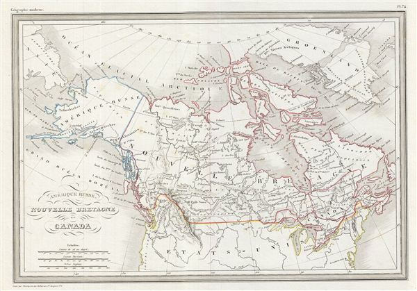
Amerique Russe, Nouvelle Bretagne et Canada.
1843 (undated) 9.5 x 13.5 in (24.13 x 34.29 cm)
1843 (undated) 9.5 x 13.5 in (24.13 x 34.29 cm)
Description
This is a fine example of Conrad Malte-Brun's 1843 map of Canada and Alaska (Russian America). It covers from the Arctic Ocean to the United States and from the Bering Sea to Newfoundland. This map identifies American claims to parts of British Columbia – a clear indicator of where French popular opinion rested regarding the Americas. These claims, by which United States territory extended northwards well into the fur-rich lands of British Columbia, eventually led to the '54-40 or Fight' dispute between the United States and Britain.
Greenland is divided into two parts, based on the belief that the ice sheet covering the country conceals two (now believed to be three) separate land masses joined by glaciers. According to the earliest written accounts, the Russians were the first europeans who reached Alaska and eventually became permanent settlers. The modern Canadian provinces and territories were under British and French control from the 16th century, until France gave up its claims in the Treaty of Paris in 1763. Canada would remain a collection of British colonies until its confederation in 1867, when the British colonies of Ontario, Quebec, New Brunswick and Nova Scotia would become Canadian provinces. Boundaries are color coded according to regions and territories. Various cities, towns, rivers, islands and other topographical details are marked, with relief shown by hachures. This map was issued as plate no. 74 in Conrad Malte-Brun's 1843 Precis de la Geographie Universelle.
Greenland is divided into two parts, based on the belief that the ice sheet covering the country conceals two (now believed to be three) separate land masses joined by glaciers. According to the earliest written accounts, the Russians were the first europeans who reached Alaska and eventually became permanent settlers. The modern Canadian provinces and territories were under British and French control from the 16th century, until France gave up its claims in the Treaty of Paris in 1763. Canada would remain a collection of British colonies until its confederation in 1867, when the British colonies of Ontario, Quebec, New Brunswick and Nova Scotia would become Canadian provinces. Boundaries are color coded according to regions and territories. Various cities, towns, rivers, islands and other topographical details are marked, with relief shown by hachures. This map was issued as plate no. 74 in Conrad Malte-Brun's 1843 Precis de la Geographie Universelle.
Cartographer
Conrad Malte-Brun (August 12, 1755 - December 14, 1826) was an important late 18th and early 19th century Danish / French cartographer and revolutionary. Conrad was born in Thisted, Denmark. His parents encouraged him to a career in the Church, but he instead enrolled in the University of Copenhagen. In the liberal hall of academia Conrad became an ardent supporter of of the French Revolution and the ideals of a free press. Despite the harsh censorship laws of crown prince Frederick VI, Malte-Brun published numerous pamphlets criticizing the Danish government. He was finally charged with defying censorship laws in 1799 and forced to flee to Sweden and ultimately France. Along with colleague Edme Mentelle, Malte-Brun published his first cartographic work, the Géographie mathématique, physique et politique de toutes les parties du monde (6 vols., published between 1803 and 1807). Conrad went on to found Les Annales des Voyages (in 1807) and Les Annales des Voyages, de la Géographie et de l'Histoire (in 1819). He also founded the Paris Société de Géographie . In time, Conrad Malte-Brun became known as one of the finest French cartographers of his time. His son Victor Adolphe Malte-Brun (1816 - July 13, 1889) followed in his footsteps, republishing many of Conrad's original 18th century maps as well as producing numerous maps of his own. The Malte-Brun firm operated well into the 1880s. More by this mapmaker...
Source
Malte-Brun, Precis de la Geographie Universelle, ou Description de Toutes les Parties du Monde sur un Plan Nouveau, d'après les Grandes Divisions Naturelles du Globe, (Paris) 1843.
Condition
Very good. Blank on verso.