This item has been sold, but you can get on the Waitlist to be notified if another example becomes available, or purchase a digital scan.
1945 Turner Pictorial Map of Postwar Canada
Canada-turner-1945$275.00

Title
Canada.
1945 (dated 1944) 20 x 26 in (50.8 x 66.04 cm) 1 : 9000000
1945 (dated 1944) 20 x 26 in (50.8 x 66.04 cm) 1 : 9000000
Description
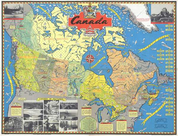
This is a 1945 Stanley Francis Turner pictorial map of postwar Canada. The map depicts the region from the Pacific Ocean to the Greenland and the Atlantic Ocean and from the Arctic Ocean and Baffin Bay to the United States. Highly detailed, numerous aspects of Canada's participation in World War II are illustrated. Various aircraft dot the skies over Canada and the Atlantic and Pacific Oceans, while a convoy bound for Britain is illustrated embarking from the east coast. Canadian WACs and other branches of the women's armed services are sketched, along with members of the 48th Highlanders, the Ski Patrol, and the Princess Louise Fusiliers. The coast defense on both the east and west coasts can be seen manning anti-aircraft guns. Air plane manufacturing plants, shipbuilders, both permanent and training military camps, and naval stations are indicated. One of the major construction projects of the era, the Alaska Highway, was completed in November 1942 and is depicted. Boxes along the right border mark some key events in Canadian involvement in World War II and banners in the bottom right corner commemorate V-E (Victory in Europe) Day and V-J (Victory over Japan) Day.
Other aspects of Canada are included here as well. Each of the provinces is labeled, along with cities and towns throughout the country, including the capitals of each of the provinces. Vignettes of farming, ranching, logging, and other industries are illustrated. Small text boxes provide some information about the provinces, and a legend along the bottom border explains the different symbols employed. Canadian wildlife also dot the map, such as caribou, polar bears, and a beaver. Eleven photographs, provided by the Canadian Pacific Railway, are included along the top and bottom borders, including one of the Chateau Frontenac and Mount Eisenhower.
This map was created by Stanley Francis Turner and published by C. C. Petersen Publishing in 1945.
CartographerS
Stanley Francis Turner (1883 – 1953) was a visual artist and painter based in Toronto, Canada. Turner was born in Aylesbury, England. He studied art in London at the South Kensington School before migrating to Canada in 1903, where he studied at Ontario College of Art under George Reid and J. W. Beatty. Turner is best known as a painter and designer capable of working in a variety of mediums. During World War II, Turner took a contract with the Globe and Mail to illustrate pictorial maps of war events. Turner may have maintained the rights to his war maps, as he also seems to have had a contract with the advertiser and publisher, C.C. Peterson, also of Toronto, to publish and distribute his maps in the United States. Turner's maps are information dense and designed to illustrate the events of the war in an easily digestible pictorial format. Turner experimented with different ways of working with the cartographic ranging from simple Mercator projections to more contemporary equal-area projections. In 1930, Turner was elected an Associate of the Royal Canadian Academy of Arts. He died in Toronto in 1953. More by this mapmaker...
C. C. Peterson (fl. c. 1940 – 1950) was an advertising and publishing company based in Toronto Canada, but with distribution and licensing in both the United States and Canada. Peterson had contracts with the artist Stanley Francis Turner to publish pictorial 'war maps' during World War II. The company supplemented its income by selling advertisements on Turner's maps. Learn More...
Condition
Very good. Wear along original fold lines. Blank on verso.
References
Rumsey 11199.000.