1854 Ensign, Bridgman, and Fanning Pocket Map of Canada
CanadaEastWest-ensign-1854$850.00

Title
Map of Canada East and West.
1854 (dated) 19.25 x 25.25 in (48.895 x 64.135 cm) 1 : 1200000
1854 (dated) 19.25 x 25.25 in (48.895 x 64.135 cm) 1 : 1200000
Description
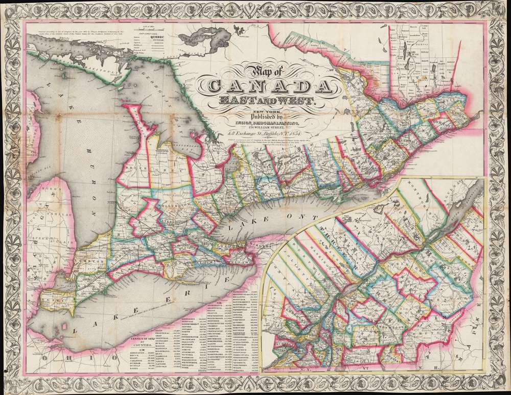
This is a striking 1854 Ensign, Bridgman, and Fanning map of Ontario and Quebec, Canada. The map captures the ephemeral period between the 1841 founding of the Province of Canada, and the 1867 Canadian Confederation.
Data from the 1852 census is included, not present in earlier editions. The close interconnection between Canada and the United States, despite their relatively recent hostilities during the War of 1812, is evident, especially at Buffalo (where Ensign had an office) and Detroit.
It is noteworthy that the map indicates the locations of Hudson Bay Company trading posts at top-left, in what is now central Ontario, illustrating the sparse white settler presence. For instance, Sudbury, the largest city in the region, was built on land leased from the Ojibwe in 1850, and the settler population remained extremely small (consisting of missionaries and traders) until the Canadian Pacific Railway provided greater access in 1880s.
A Closer Look
This map illustrates administrative divisions of Canada West (Ontario) and Canada East (Quebec) to the county level, as well as waterways (including canals), cities, towns, and railways (including proposed). The more densely populated Canada West composes the main map while Canada East occupies an inset at bottom-right.Data from the 1852 census is included, not present in earlier editions. The close interconnection between Canada and the United States, despite their relatively recent hostilities during the War of 1812, is evident, especially at Buffalo (where Ensign had an office) and Detroit.
It is noteworthy that the map indicates the locations of Hudson Bay Company trading posts at top-left, in what is now central Ontario, illustrating the sparse white settler presence. For instance, Sudbury, the largest city in the region, was built on land leased from the Ojibwe in 1850, and the settler population remained extremely small (consisting of missionaries and traders) until the Canadian Pacific Railway provided greater access in 1880s.
Canada's Evolution from Colonies to Confederation
This map was made after the 1841 union of Upper and Lower Canada to form the Province of Canada. New Brunswick and Nova Scotia were not added until 1867, with other territories added subsequently, explaining their absence here. Canada had recently seen uprisings (1837) pushing for greater political reforms and autonomy for the Quebequois. The union of the two Canadas and the institution of 'responsible government' was meant to address these concerns, but discontent remained among supporters of the uprisings and Tories opposed to them. Tories burned down the Canadian Parliament in 1849 to protest what they saw as an overly generous amnesty to former rebels. Additionally, migration from the British Isles increased rapidly throughout the 1830s-40s due to land clearances and famines in Scotland and Ireland, which quickly had a political impact. In the mid-1860s, the Province of Canada confederated with New Brunswick and Nova Scotia, and greater autonomy was granted to the newly-created entity, the first Dominion of the British Empire.Publication History and Census
This map was made by Edward Ensign with his partners Bridgman and Fanning and was printed by David McLellan in 1854. It is based on an earlier edition published in 1848 by Ensign and Thayer. An intermediate edition was published in 1853, explaining the copyright at top-left, and additional editions may have been published in the intervening years (late 1840s - early 1850s). All editions are quite rare, with the OCLC indicating six institutions holding any edition of the map. The current edition has no known history on the market.CartographerS
Edward Hooker Ensign (August 18, 1818 - July 10, 1871) was an American map and print publisher based in New York during the middle part of the 19th century. Edward was born in West Hartland, Connecticut. Little is known of Ensign's training but he may have inherited his business from his father, Timothy Ensign (1795 - 1859), who was a map publisher active in New York. Ensign seems to have had a flair for partnerships and variously published with Humphrey Phelps (1799 - 1875), Horace Thayer, Thomas C. Fanning (1805 - 1873) and Erastus C. Bridgman (1817 - 1870), among others. His various imprints include 'Phelps and Ensign' (1841-1844), 'T. and E. H. Ensign' (1844-1848), 'Ensign and Thayer' (1849), 'Ensign, Thayer, and Company' (1850-1851), 'Horace Thayer and Company' (1852), and 'Ensign, Bridgman and Fanning' (1854-1863). It appears that father and son worked together for some time as well, publishing as either 'T. and E. H. Ensign' or 'Ensigns'. At least some of these companies maintained offices in both Buffalo and New York City. More by this mapmaker...
David McLellan (September 20, 1825 - July 26, 1867) was a Scottish-American lithographer and printer active in New York City in the middle part of the 19th century. McLellan was born Pollockshaws, Renfrewshire, Scotland. He lived in Glasgow for about 20 years, where he mastered printing and lithography under his father James McLellan (1798 - 18??). In 1847, he immigrated to New York City with his brother, James McLellan. David initially printed under his own name, 'David McLellan (1851 - 1854), the with in partnership with his brother, James, as 'D and J. Mclellan' (1855 - 1860). Aging under his own name during the Civil War from 1862 -1863. Then as 'David McLeland and Brothers' (1864 - 1866). He joined the mostly Scottish 79th 'Highlander' Regiment, with whom he participated with the rank of 'Major' in the American Civil War (1862 - 1865). During his long career as a New York lithographer, McLellan worked with many prominent publishers, including J. H. Colton, Edward Valois, James Ackerman, the U.S. Coast Surrey. After his death in 1867 he was interred in Greenwood Cemetery. The McLellan printing business continued after his death under the imprint of John McLellan (1867 - 1868) and J. (John) and R. (Robert) McLellan (1869). No further McLellan work is known after 1869. Learn More...
Condition
Good. Foxing along fold lines. Some loss at fold intersections.
References
Rumsey 2959.002. OCLC 900262537.