This item has been sold, but you can get on the Waitlist to be notified if another example becomes available, or purchase a digital scan.
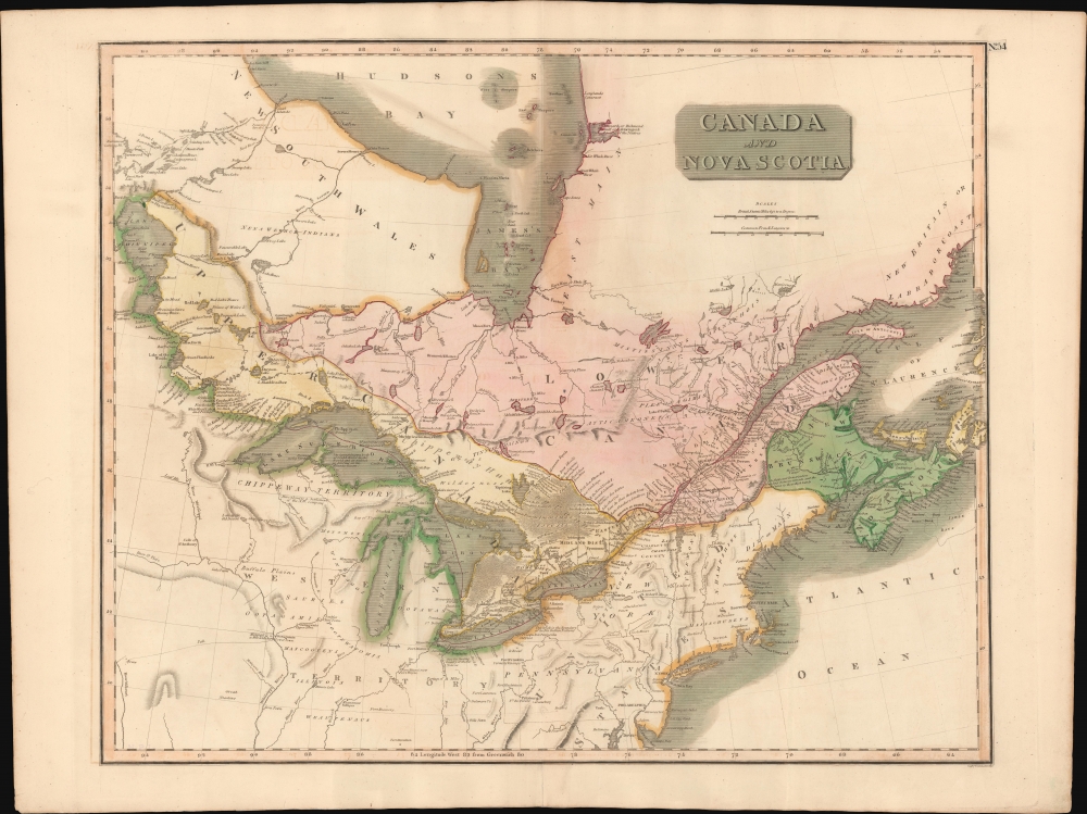
1814 Thomson Map of the Great Lakes and Canada
CanadaGreatLakes-thomson-1814$225.00

Title
Canada and Nova Scotia.
1814 (dated) 20 x 25 in (50.8 x 63.5 cm) 1 : 4800000
1814 (dated) 20 x 25 in (50.8 x 63.5 cm) 1 : 4800000
Description
This is John Thomson's 1814 map of Canada and the Great Lakes. Although intended to focus on Ontario and Quebec, this is also Thomson's best and largest scale map of all five Great Lakes.
A Closer Look
Coverage extends from Lake Winnipeg to Cape Breton Island and from the Hudson Bay to the Chesapeake Bay. The m ap is focused on the British provinces of Upper and Lower Canada (Ontario and Quebec), as well as the network of rivers and lakes connecting the Gulf of St. Lawrence, to the Great Lakes, and these to the Lake of the Woods, Lake Winnipeg, and Hudson Bay. It fascinatingly notes American Indian villages as well trading posts throughout - underscoring the significance of the fur trade to this region.Publication History and Census
This is the 1814 first edition of Thomson's map from the 1817 first edition of the New General Atlas. Subsequent editions were published through 1826. The map was engraved in Edinburgh by W. Dassauville.CartographerS
John Thomson (1777 - c. 1841) was a Scottish cartographer, publisher, and bookbinder active in Edinburgh during the early part of the 19th century. Thomson apprenticed under Edinburgh bookbinder Robert Alison. After his apprenticeship, he briefly went into business with Abraham Thomson. Later, the two parted ways, John Thomson segueing into maps and Abraham Thomson taking over the bookbinding portion of the business. Thomson is generally one of the leading publishers in the Edinburgh school of cartography, which flourished from roughly 1800 to 1830. Thomson and his contemporaries (Pinkerton and Cary) redefined European cartography by abandoning typical 18th-century decorative elements such as elaborate title cartouches and fantastic beasts in favor of detail and accuracy. Thomson's principle works include Thomson's New General Atlas, published from 1814 to 1821, the New Classical and Historical Atlas of 1829, and his 1830 Atlas of Scotland. The Atlas of Scotland, a work of groundbreaking detail and dedication, would eventually bankrupt the Thomson firm in 1830, at which time their plates were sequestered by the court. The firm partially recovered in the subsequent year, allowing Thomson to reclaim his printing plates in 1831, but filed again for bankruptcy in 1835, at which time most of his printing plates were sold to A. K. Johnston and Company. There is some suggestion that he continued to work as a bookbinder until 1841. Today, Thomson maps are becoming increasingly rare as they are highly admired for their impressive size, vivid hand coloration, and superb detail. More by this mapmaker...
William Dassauville (17xx - October 17, 1851) was a French-Scottish engraver active in Edinburgh in the late 18th and early 19th centuries. Dassauville was descended from French Protestant refugees who emigrated to Edinburgh in the late 17th century. He engraved for John Thomson, and others. Learn More...
Source
Thomson, J., A New General Atlas, (Edinburgh: Baldwin, Craddock, Joy) 1817.
Thomson's New General Atlas was first published in 1817 and continued to be published until about 1821. This is the first of Thomson's major cartographic works and the atlas for which is most celebrated. The New General Atlas follows in the Edinburgh School, which eschews excessive decoration in favor of a more minimalistic fact-based cartographic vision, as established by John Pinkerton, Laurie and Whittle, John Cary, and others in the previous decades. The maps are notable for their massive scale, heavy stock, elegant color work, and easy-to-read typefaces. Although the atlas stopped being published after 1821, Thomson continued to offer 'supplementary' maps that could be tipped into the atlas as late as 1830, when he declared bankruptcy. The maps in the Thomson Atlas were engraved by Thomas Clerk, William Dassauville, Nathaniel Rogers Hewitt, James Kirkwood, Robert Kirkwood, John Menzies, George Menzies, Edward Mitchell, John Moffatt, Samuel John Neele, Robert Scott, and James Wyld.
Condition
Very good. Some offsetting. Wear on original centerfold. Wide margins.
References
Rumsey 1007.058. Newberry Library: Ayer +135 T4 1817 no. 54.